Give us feedback!


 See all

Our philosophy is simple. We want to encourage you to dream. BIG! Then we help you plan your trip, get the most out of it while you're traveling and help you share your experience with friends.
Join Now It's FREE
Dream Packages
Duration: 5 hours
Price: $106.33
Price: $106.33
Duration: 4 hours 30 minutes
Price: $176.03
Price: $176.03
Duration: 4 hours
Price: $120.43
Price: $120.43
Duration: 8 hours
Price: $208.72
Price: $208.72
Dreams Still To Do
Checked-Off Dreams
Dreams Still To Do
Checked-Off Dreams
Advertisement
Explore Adventure Sports
-
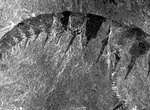
Explore Burgess Shale Fossil Beds, Yoho National Park, Canada
The Burgess Shale Formation is a fossil field in the Canadian Rockies of British Columbia, Canada. It is famous for the exceptional preservation of the soft parts of its fossils. At 508 million years (Middle Cambrian) old, it is one of the earliest fossil beds containing soft-part imprints. The rock unit is a black shale and crops out at a number of localities near th... -
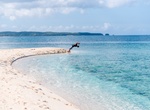
Explore Burias Pass, Luzon, Philippines
Burias Pass is the strait that separates Burias Island from the Bicol Peninsula in the Philippines. It connects the Ragay Gulf in the north with the Ticao Pass and Samar Sea in the south. It is considered a very important biodiversity area of the country. Along with the Ticao Pass, the waters of the Burias Pass are proposed to become a Marine Protected Area. The pass ... -
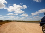
Drive Burkett Road, Western Australia
Burkett Road is a main east-west road in Exmouth Gulf near the northern edge of the Gascoyne. It links North West Coastal Highway with Minilya–Exmouth Road. -
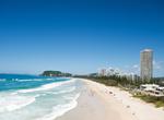
Visit Burleigh Heads, Queensland, Australia
Burleigh Heads is a beachside town in Queensland famous for its ideal surfing conditions, is the location for many pro surfing competitions and is an alternative to the more tourist ridden towns of the Gold Coast. The centre of Burleigh Heads is James Street, a village consisting of cafes, delis, hairdressers, retailers, chemists, restaurants and charity stores. The n... -
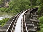
Hike Burma Railway (Death Railway) & Bridge on the River Kwai, Thailand
The Burma Railway, also known as the Death Railway, the Thailand–Burma Railway and similar names, was a 415 kilometres (258 mi) railway between Bangkok, Thailand, and Rangoon, Burma (now Yangon, Thailand , built by the Empire of Japan during World War II, to support its forces in the Burma campaign. Forced labour was used in its construction. About 180,000 Asian... -
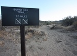
Hike Burnt Hill Trail, Joshua Tree National Park, California
Burnt Hill Trail is located off the Black Rock Canyon Trail in Joshua Tree National Park, California. Leave from the backcountry registration board and hike south on Black Rock Canyon Trail. Turn left at the Burnt Hill Trail sign. Return via Eureka Peak Trail, Fault Trail, and California Riding & Hiking Trail. Alternately, depart from site #30 via Black Rock Canyo... -
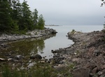
Hike Burnt Point Loop Trail, Bruce Peninsula, Ontario, Canada
The Burnt Point loop was built by volunteers of the Peninsula Bruce Trail Club for the opening of the Visitor Centre in 2006. The Burnt Point Loop trail is accessible from the Visitor Center and takes about 1.5 - 2 hours to hike. The first part, about 800 meters, to the bay is wheel chair friendly. -
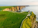
Hike Burren Way, County Clare, Ireland
The Burren Way (Irish:Slí Bhoirne) is a long-distance trail in County Clare, Ireland. It is 114 kilometres (71 miles) long, begins in Lahinch and ends in Corofin, crossing The Burren, one of the largest karst limestone landscapes in Europe. The trail, typically completed in five days, comprises sections of tarmac road, boreen, droving road, path and forestry tr... -
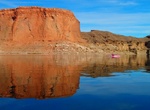
Fish Burro Bay, Lake Mead, Nevada
Burro Bay is located on the Nevada side of Lake Mead, east of Temple Bar. The bay is good for largemouth bass most of the year and striped bass year-round. Boats and gear can be rented or purchased from Las Vegas Boat Harbor or Callville Bay Marina. TIPS: To fish within the states of Nevada or Arizona, you must carry with you a valid fishing license. Tap here fo... -
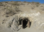
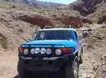
Off-road to Burro Schmidt Tunnel, California
The historic Burro Schmidt Tunnel is located in the El Paso Mountains of the northern Mojave Desert, in eastern Kern County, Southern California. It is a 0.5 miles (0.80 km) mining tunnel dug with hand tools and dynamite over a 38-year period by William "Burro" H. Schmidt (1871–1954) in the El Paso Mountains of eastern California. The tunnel is below the summit ... -
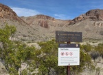
Hike Burro Spring Trail, Big Bend National Park, Texas
Burro Spring does not always have water. There are several interesting displays of geology in the form of walls and boulders. -
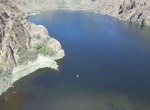
Off-road to Burro Wash, Colorado River, Nevada
The end of the trail at Burro Wash is a great place for picnicking, relaxing and even taking a quick dip! Just make sure you’re equipped to reach it. The road to Burro Wash requires a 4x4 vehicle and will take you down some rocky descents, sandy washes and over a few minor (but fun) rock obstacles. Don’t forget your chairs, shade and lunch! Access: Burro... -
Off-road Burro Wash 4x4 Trail, Colorado River, Nevada
Burro Wash 4x4 Trail is an out-and-back trail that starts just south of Boulder City and ends at the Colorado River, so be sure to pack a picnic, swim gear and some shade. The trail will have some minor washed-out areas, slightly off-camber spots and minor rocky obstacles, but is considered moderate and fun. You can expect to initially follow a dirt and rock trail alo... -
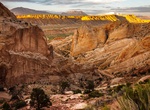
Drive Burr Trail Road in Capitol Reef National Park
The Burr Trail road in Capitol Reef National Park, Utah was originally a cattle trail blazed by stockman John Atlantic Burr, extends from the town of Boulder on Utah Hwy 12 to the Notom-Bullfrog Road, and continues to the Bullfrog Marina and Glen Canyon National Recreation Area. Views of the Henry Mountains, the colorfully contorted Waterpocket Fold, red Circle C... -
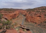
Drive Burr Trail Road in Staircase-Escalante National Monument
The Burr Trail is an excellent back country road that links Boulder on UT 12 with the Notom-Bullfrog Road near the south end of Capitol Reef National Park. A majority of the road is in Grand Staircase-Escalante National Monument. The road within the National Monument is 30 miles to the Capitol Reef boundary and now is paved.
Price: $99.36