Give us feedback!


 See all

Our philosophy is simple. We want to encourage you to dream. BIG! Then we help you plan your trip, get the most out of it while you're traveling and help you share your experience with friends.
Join Now It's FREE
Dream Packages
Duration: 8 hours
Price: $208.72
Price: $208.72
Duration: 3 hours
Price: $173.83
Price: $173.83
Duration: 6 days
Price: $606.00
Price: $606.00
Duration: 5 hours
Price: $106.33
Price: $106.33
Dreams Still To Do
Checked-Off Dreams
Dreams Still To Do
Checked-Off Dreams
Advertisement
Explore Adventure Sports
-
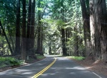
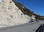
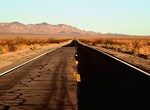
Drive California State Route 128
State Route 128 (SR 128) is a state highway in the U.S. state of California, connecting the Mendocino coast to the Central Valley through the state's Wine Country. Route 128 begins at Route 1 near the mouth of the Navarro River at the Pacific Ocean. The highway travels upriver through the coast redwood forests of Navarro River Redwoods State Park and through the viney... -
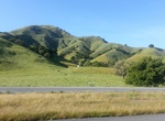
Drive California State Route 152
State Route 152 (SR 152) is a state highway that runs near the latitudinal middle of the U.S. state of California from Watsonville to Route 99 southeast of Merced. Its western portion (which is also known as Pacheco Pass Road and Pacheco Pass Highway) provides the best access to and from Interstate 5 toward southern California for motorists in or near San Jose. This r... -
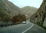
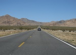
Drive California State Route 178 (Bakersfield to Trona), California
State Route 178 (SR 178) is a state highway in the U.S. state of California that exists in two constructed segments. The gap in between segments is connected by various local roads and State Route 190 through Death Valley National Park. The western segment runs from State Route 99 in Bakersfield and over the Walker Pass in the Sierra Nevada to the turnoff for the Tron... -
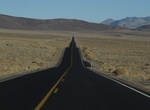
Drive California State Route 178 (Death Valley to Nevada), California
State Route 178 (SR 178) is a state highway in the U.S. state of California that exists in two constructed segments. The gap in between segments is connected by various local roads and State Route 190 through Death Valley National Park. The western segment runs from State Route 99 in Bakersfield and over the Walker Pass in the Sierra Nevada to the turnoff for the Tron... -
Drive California State Route 18 (CR 18), California
California State Route 18 (SR 18) is a state highway in the U.S. state of California. It serves as a primary route into the San Bernardino Mountains, both from the Riverside–San Bernardino metropolitan area from the south and the Mojave Desert from the north. SR 18 runs from State Route 210 in San Bernardino to State Route 138 in Llano. It has two discontinuitie... -
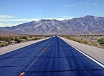
Drive California State Route 190, California
State Route 190 (SR 190) is a state highway in the U.S. state of California that is split into two parts by the Sierra Nevada. The western portion begins at Tipton at a junction with State Route 99 and heads east towards Porterville before ending at Quaking Aspen in the Sequoia National Forest. The eastern portion begins at US 395 at Olancha, heads east through Death ... -
Drive California State Route 247 (Old Woman Springs Road), California
California State Route 247 (SR 247) is a state highway in the U.S. state of California. The road passes through the Mojave Desert in San Bernardino County, connecting SR 62 in Yucca Valley to Interstate 15 (I-15) in Barstow. SR 247 runs along Old Woman Springs Road between Yucca Valley to Lucerne Valley, and Barstow Road between Lucerne Valley and Barstow. SR 247 was ... -
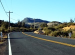
Drive California State Route 38
State Route 38 (SR 38) is a mostly rural and scenic road in the U.S. state of California. Despite the orientation of its alignment, SR 38 is assigned in a west–east direction. This route is part of the California Freeway and Expressway System and is eligible for the State Scenic Highway System. However, it is only a scenic highway between a point east of the Sou... -
Drive California State Route 49
State Route 49 (SR 49) is a north–south state highway in the U.S. state of California that passes through many historic mining communities of the 1849 California gold rush. Highway 49 is numbered after the "49ers", the waves of immigrants who swept into the area looking for gold, and it is known as the Golden Chain Highway. This roadway begins at Oakhurst, Mader... -
Drive California State Route 62 (29 Palms Hwy), California
State Route 62 (SR 62) is a state highway in the U.S. state of California that cuts across the Little San Bernardino Mountains in Riverside and San Bernardino counties. Its western terminus is at Interstate 10 in unincorporated Riverside County outside the borders of Whitewater and Palm Springs. Its eastern terminus is at the Arizona state line just east of Parker, Ar... -
Drive California State Route 79 (SR79), San Diego County, California
State Route 79 (SR 79) is a state highway in the U.S. state of California. The route begins at Interstate 8 (I-8) in San Diego County, continuing north through the town of Cuyamaca into Julian. After passing through Warner Springs, the route crosses into Riverside County, providing access to the cities of Temecula and Murrieta. SR 79 ends at I-10 in Beaumont. SR 79 be... -
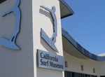
Visit California Surf Museum, Oceanside, California
The California Surf Museum is a museum located at 312 Pier View Way in Oceanside, California, dedicated to archiving and displaying surfboards, surf art, memorabilia, surfing equipment, photographs, magazines, videos, and more. The California Surf Museum's permanent time line of surfboards includes wooden boards from the early 1900s to today's modern boards. The ... -
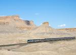
Ride California Zephyr, Chicago-Emeryville
The California Zephyr is a 2,438 mi (3,924 km) long passenger train route operated by Amtrak in the midwestern and western United States. It runs from Chicago, Illinois, in the east to Emeryville, California, in the west, passing through the states of Illinois, Iowa, Nebraska, Colorado, Utah, Nevada, and California. This route is the longest and one of the most scenic... -
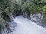
Hike Callery Gorge Walk, New Zealand
The Callery Gorge Walk in Westland Tai Poutini National Park begins in the Franz Josef Waiau township, at the end of Cowan Street. This 10.4 km up and back trail climbs to a high terrace before descending to the Callery River. The track narrows through the rainforest, and follows alongside an old gold mining water race. The water race and some rusty relics are among t... -
Hike Call of the Canyon Trail (West Fork Oak Creek), Red Rock-Secret Mountain Wilderness, Arizona
Call of the Canyon Trail is located in Oak Creek Canyon north of Sedona, Arizona. The trail follows West Fork Oak Creek. It's shaded most of the hike, and frequently crosses the creek so you can stop and refresh. The 3.2 mile hike takes 2-3 hours round trip. Call Of The Canyon Picnic Site is a picturesque day use site in Oak Creek Canyon is at the trailhead. There i...

Price: $120.43