Give us feedback!


 See all

Our philosophy is simple. We want to encourage you to dream. BIG! Then we help you plan your trip, get the most out of it while you're traveling and help you share your experience with friends.
Join Now It's FREE
Dream Packages
Duration: 3 hours
Price: $173.83
Price: $173.83
Duration: 15 hours
Price: $149.00
Price: $149.00
Duration: 7 hours
Price: $179.00
Price: $179.00
Duration: 8 hours
Price: $83.37
Price: $83.37
Dreams Still To Do
Checked-Off Dreams
Dreams Still To Do
Checked-Off Dreams
Advertisement
Explore Adventure Sports
-
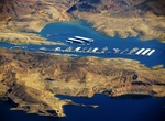
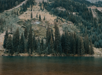
Visit Callville Bay Resort & Marina, Nevada
Boasting more than 550 miles of pristine shoreline, soaring red rock cliffs as well as countless bays and beaches, few places can beat the recreational opportunities that await you at Callville Bay Resort & Marina on Lake Mead. Conveniently located within an hour of the Las Vegas strip, Callville Bay offers the features of a relaxing getaway mixed with adventure a... -
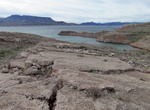
Hike Callville Summit Trail, Nevada
A short climb will reward hikers with a spectacular view. To the south sit Fortification Hill, Boulder Basin, Hemenway Valley, Boulder City and the River Mountains. Looking east, hikers can see the Callville Bay developed area, Callville Mesa and the Black Mountains. The Trailhead is located next to the Callville dump station across from the picnic area. Distance: 1... -
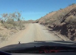
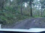
Off-road or Mountain Bike Callville Wash North Trail, Nevada
A fairly easy drive, Callville Wash North Trail gives you the thrill of driving in the wilderness without ever being more than 2 miles from the paved Northshore Road. Although in most conditions, it can probably done in a 2WD vehicle like a Jeep, 4WD is recommended for safety, as the second half of the drive gets rougher and rockier. Always check the weather report be... -
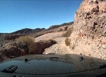
Off-road or Mountain Bike Callville Wash South Trail, Nevada
The Callville Wash South Road is a dirt road along the bed of Callville Wash, running from Northshore Road and featuring 5 miles of rugged desert landscape, including sandstone bluffs and imposing mountains. It is a fairly safe road that ends across the water from Callville Bay, but does have some sections where a 4WD is highly recommended. TIPS: Pay attention t... -
Off-road Callville Wash Trail, Lake Mead, Nevada
This is an easy off-road trail near the site of historic Fort Callville that was established as a Mormon outpost, shut down in 1869, and put underwater with the filling of Lake Mead in the 1930s. Distance: 12 miles out and back How to Get There: Calville Wash Trail is located between mile markers 13 & 14 along Northshore Drive in Lake Mead NRA TIPS: Fee ... -
Hike or Bike Calumet Trail, Indiana Dunes National Park, Indiana
The trail follows the South Shore Railroad tracks and NIPSCO power lines. There is no shade. The trail can be impassible (i.e. wet shoes) due to standing water along much of the trail that can be 4-6" deep in spots. The trail is not suitable for road bikes.The Calumet Trail connects to many trail systems. The west trailhead parking lot connects to the Porter Brickyard... -
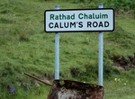
Drive Calum's Road, Isla of Raasay, Scotland
One man spent 10 years building a spectacular section of road because no one else would on the Island of Raasay, Scotland. Malcolm Macleod (Calum Macleòid) (15 November 1911 – 26 January 1988) was Local Assistant Keeper of Rona Lighthouse and the part-time postman for the north end of Raasay. -
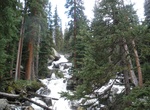
Hike to Calypso Cascades, Colorado
Calypso cascades is a multi tiered waterfall which offers multiple angles to photograph. A short trail to a broad waterfall tumbling over mossy boulders, known for wild orchids in summer. -
Fish at Cama Beach State Park, Island County, Washington
Cama Beach State Park is a Washington state park facing Saratoga Passage on the southwest shore of Camano Island in Island County, preserving the site of a renovated and modernized, 1930s-era auto court and fishing resort. Park activities include boating, crabbing, scuba diving, fishing, swimming, hiking on 15 miles of trails, wildlife viewing, and horseshoes. A mile-... -
Ride through Cambanoora Gorge, Queensland, Australia
The Cambanoora Gorge runs between the source of the Condamine River and the town of Killarney in Queensland, Australia. It is also known as the Condamine Gorge or the 14 River Crossings. The gorge begins in the historical area of The Head which is borderd by Wilsons Peak to the east and Mount Superbus to the north. Commencing at this broad grassland, the Gorge narrows... -
Snorkel Cam Bay National Park, Great Camanoe, BVI
Cam Bay National Park is 19.6 acres on Great (Gran) Camanoe island in the BVI's. It has a shallow reef that is great for Snorkelers and divers as well as bird sanctuary. It's a popular stop with sailors since it is known for calm waters. There are no moorings in the bay but it does offer a good day anchorage. -
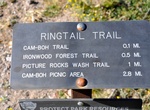
Hike & Ride Cam-Boh Trail, Saguaro National Park, Arizona
This trail runs parallel to Picture Rocks Road from Cam-Boh Picnic Area to the Ringtail Trail. As a major connection between the east and west parts of the Tucson Mountain District, the Cam-Boh Trail pro - vides several loop opportunities for both equestrians and hikers. -
Ride Camel
Humans have been riding camels since long before recorded time. Even though camels are know for being mean, spitting and smell, they offer a unique way to get from point A to B (and maybe back to A). -
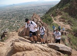
Hike Camelback Mountain, Phoenix, Arizona
Camelback Mountain is a mountain in Phoenix, Arizona, United States. The English name is derived from its shape, which resembles the hump and head of a kneeling camel. The mountain, a prominent landmark of the Phoenix metropolitan area, is located in the Camelback Mountain Echo Canyon Recreation Area between the Arcadia neighborhood of Phoenix and the town of Paradise... -
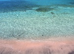
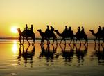
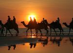
Ride Camel on Cable Beach, Western Australia
Sunset camel rides operate daily along Cable Beach in Western Autralia. The beach is 22.5 km long with beautiful white sand, washed clean daily by tides that can reach over 9 meters. The water is crystal clear turquoise, and the gentle swells hardly manage to topple over as they roll up onto the almost perfectly flat beach. The beach is named in honor of the Java-to-A...

Price: $106.33