Give us feedback!

Our philosophy is simple. We want to encourage you to dream. BIG! Then we help you plan your trip, get the most out of it while you're traveling and help you share your experience with friends.
Join Now It's FREE
Related Categories
Dreams Still To Do
Checked-Off Dreams
Dreams Still To Do
Checked-Off Dreams
Advertisement
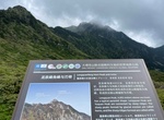
Explore UNESCO Global Geopark
-
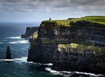
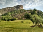
Explore Burren and Cliffs of Moher Geopark, Ireland
The Burren and Cliffs of Moher Geopark (formally The Burren and Cliffs of Moher UNESCO Global Geopark) is an internationally designated area of geological interest in County Clare, Ireland. It was the third Geopark to be designated in Ireland, and is recognised at both European and global levels. The geopark began as a mid-2000s project of Clare County Council and the... -
Explore Buzău Land UNESCO Global Geopark, Romania
In the Carpathian Bend Area in Romania, the hilly and mountainous territory of the Buzău Land UNESCO Global Geopark covers 1,036 km² and is home to some 45,000 inhabitants. Several tectonic plates collided in the region, creating a very complex fold and thrust mountain range which was later eroded by glacial action. One of the most geodynamically active areas in ... -
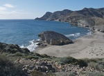
Explore Cabo de Gata-Níjar Natural Park, Spain
Cabo de Gata-Níjar Natural Park in the south-eastern corner of Spain, is Andalucia's largest coastal protected area, a wild and isolated landscape with some of Europe's most original geological features. It is the only region in Europe with a Warm Desert climate. The eponymous mountain range of theSierra del Cabo de Gatawith its highest peak El Fraile is Spain'... -
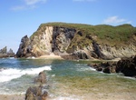
Explore Cabo Ortegal Geopark, Spain
Most of the rocks in Cabo Ortegal Geopark were brought to the surface by the collision of two continents, Laurussia and Gondwana, which would eventually join the supercontinent Pangaea about 350 million years ago. -
Explore Caçapava Geopark, Brazil
Caçapava Geopark is located in the southernmost part of Brazil. It's of great significance to the Guarani, an indigenous people in Brazil. There are several geosites within the geopark, including Serra do Segredo, Guaritas, and Minas do Camaquã. -
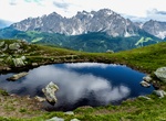
Explore Carnic Alps Geopark, Austria
The Carnic Alps are a range of the Southern Limestone Alps in Austria and northeastern Italy. They are within Austrian East Tyrol and Carinthia, and Italian Friuli (Province of Udine) and marginally in Veneto of the Friuli-Venezia Giulia region. They are named after the Roman province of Carnia, which probably has a Celtic origin. The mountains gave their name to the ... -
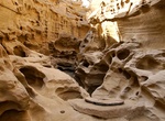
Visit Chahkooh Canyon, Qeshm Island, Iran
Geological landmark with rain-carved rock formations & human-made wells, listed as a UNESCO Geopark. -
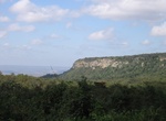
Explore Chapada do Araripe, Brazil
The Araripe UNESCO Global Geopark is located in the Araripe Basin, which is considered the largest sedimentary basin in the Brazilian Northeast inland extending into the South of Ceará State, Pernambuco´s northwest and Piaui´s east. The Araripe Plateau is its main distinction, in terms of relief. The geological heritage of the Geopark is characteriz... -
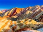
See China's Danxia Landscapes, China (UNESCO site)
China Danxia is the general name of the unique type of landscapes, Danxia landform, formed from red sandstone and characterised by steep cliffs, which are caused by endogenous forces (including uplift) and exogenous forces (including weathering and erosion). In August 2010, China Danxia was inscribed onto the World Heritage List. The view is a lof of these sites are b... -
Explore Cliffs of Fundy UNESCO Global Geopark, Nova Scotia, Canada
On the North shore of the Minas Basin in Nova Scotia, Canada, the Geopark features a varied landscape of hills, mountains, valleys, heavily forested areas, and coastal marshlands. Its broad biodiversity includes rare birds, fungi and plants. Minas Basin, an inlet in the Bay of Fundy, which is known for having the highest tides on Earth, is part of the Geopark that fea... -
Explore Coco River UNESCO Global Geopark, Nicaragua and southern Honduras
River Wangki in Miskitu or Río Coco, in Spanish, formerly known as the Río Segovia, Cape River, or Yara River, is a river located on the border of northern Nicaragua and southern Honduras. It is the longest river that runs entirely within the Central American isthmus with a total length of 841 km (523 mi). The river originates in the Somoto Canyon Nation... -
Explore Copper Coast Geopark, Ireland
The Copper Coast Geopark is a designated area comprising a stretch of the southern coast of Ireland in County Waterford, extending for some 17 km from Kilfarrasy in the east to Stradbally in the west. It was the first geopark designated in the state, and the second on the island. The coast, and the geopark, are named for the historic metal-mining industry, the legacie... -
Explore Dali-Cangshan UNESCO Global Geopark, Yunnan Province
Dali-Cangshan UNESCO Global Geopark is located in China’s Yunnan province. Dali-Cangshan UNESCO Global Geopark is located in the central section of the Bai Nationality Autonomous Prefecture, including Dali City, Yangbi County and Eryuan County. Located in western Yunnan Province at the southern end of the lofty Qinghai-Tibet Plateau, Mount Cangshan is a young m... -
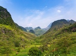
Explore Dong Van Karst Plateau Geopark, Vietnam
Dong Van Karst Plateau Geopark (Vietnamese:Cao nguyên đá Đồng Văn) is a geopark in northern Vietnam. It shares border with China in the north. It is a member of the UNESCO Global Geoparks Network and Asia Pacific Geoparks Network, officially since Oct 3, 2010. Dong Van Karst Plateau Geopark is located in Hà Giang Province, the northernmost province... -
Visit Dunhuang, China
Dunhuang is a city in northwestern Gansu Province, Western China. Dunhuang was a major stop on the ancient Silk Road and is best known for the nearby Mogao Caves. It has also been known at times as Shazhou and, in Uyghur, Dukhan. Dunhuang is situated in a oasis containing Crescent Lake and Mingsha Shan (鸣沙山, meaning "Singing-Sand Mountain"), named after the sound of t...