Give us feedback!

Our philosophy is simple. We want to encourage you to dream. BIG! Then we help you plan your trip, get the most out of it while you're traveling and help you share your experience with friends.
Join Now It's FREE
Related Categories
Dreams Still To Do
Checked-Off Dreams
Dreams Still To Do
Checked-Off Dreams
Advertisement
Explore UNESCO Global Geopark
-
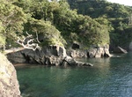
Explore Izu Peninsula Geopark, Japan
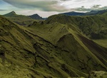
The Izu peninsula (Izu-hantō) is a large mountainous peninsula with deeply indented coasts to the west of Tokyo on the Pacific coast of the island of Honshū, Japan. Formerly the eponymous Izu Province, Izu peninsula is now a part of Shizuoka Prefecture. Tectonically, the Izu peninsula results from the Philippine Sea Plate colliding with the Okhotsk Plate at the Nankai... -
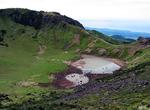
Visit Jeju Volcanic Island, South Korea (UNESCO site)
The Jeju Volcanic Island and Lava Tubes is a World Heritage Site in South Korea. Jejudo is a volcanic island, 130 kilometers from the southern coast of Korea. The largest island and smallest province in Korea, the island has a surface area of 1,846 square kilometers. A central feature of Jeju is Hallasan, the tallest mountain in South Korea and a dormant volcano, whic... -
Explore Jeonbuk West Coast Geopark, South Korea
TheJeonbuk West CoastGeoparkis located in the midwestern part of South Korea. It includes vast tidal flats dotted with volcanoes and islands. It's one of 19 coastal wetland areas in the world with a tidal range greater than 5 m (macrotidal). Some of the sites include: Simwon Mud flat Soyosan Mountain Lava dome Seonunsan Mountain Byeong Rock Jigso Fall ... -
Explore Karawanken/Karavanke UNESCO Global Geopark, Slovenia and Austria
The Karawanks or Karavankas or Karavanks (Slovene:Karavanke; German:Karawanken, German pronunciation: [kaʁaˈvaŋkŋ̍] (listen)) are a mountain range of the Southern Limestone Alps on the border between Slovenia to the south and Austria to the north. With a total length of 120 kilometres (75 mi) in an east–west direction, the Karawanks chain is one of the longest r... -
Explore Katla Geopark, Iceland
Katla Geopark is the first Geopark to be designated in Iceland, having gained membership of both the European Geoparks Network and the UNESCO-assisted Global Network of National Geoparks in 2011. Amongst others, it includes the volcanoes Katla and Eyjafjallajökull, the latter renowned for the disruption which its eruption in 2010 caused to European air travel. -
Explore Kefalonia-Ithaca UNESCO Global Geopark, Greece
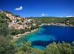
In Western Greece, the Kefalonia – Ithaca UNESCO Global Geopark is an island complex belonging to the Heptanese (from the Greek for seven, the number of principal Ionic islands). Kefalonia occupies an area of 773 km² and is home to 35,801 inhabitants and Ithaca’s 117 km² are inhabited by3,084 people. The geopark is rich in geosites of karstic ori... -
Explore Kinabalu Geopark, Sabah, Malaysia
Kinabalu Geopark is lcoated at the northern end of the island of Borneo, Malaysia. Covering an area of 4,750 km2, the geopark is home to many endemic plants and animals, including 90 orchid species that exist only on Mount Kinabalu. -
Explore Kula Volcanic Geopark, Turkey
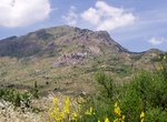
Kula Volcanic Geopark, also known as Kula Geopark is a geopark, a protected area of geological heritage, located in Kula, Manisa, western Turkey. It was recognized by UNESCO as a UNESCO Global Geopark in 2013, and is the country's only geopark. The volcanic park is located in Manisa Province in western Turkey, covering an area of nearly 300 km2 (120 sq mi) mainly in K... -
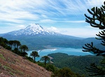
Explore Kütralkura Geopark, Chile
Kütralkura is a geopark in southern Chile's Araucanía Region. The geopark has an area of 8100 km2 and lies mostly in the Andes. It spans four communes: Curacautín, Lonquimay, Melipeuco and Vilcún. All of Conguillio National Park and Llaima, one of Chile's most active volcanoes, lie within the geopark. 2019, Kütralkura was being considere... -
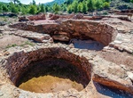
Explore Lavreotiki Geopark, Greece
Lavreotiki Geopark is located 60 km drive-distance from Athens and is known around the world for the silver that is extracted from mixed sulfide deposits. It includes approximately 1000 mining sites and the same number of wells and 22 geosites. -
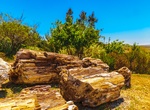
Explore Lesvos Geopark, Greece
The petrified forest of Lesbos is a petrified forest on Lesbos in Greece. It has been designated as a protected natural monument. The petrified forest of Lesbos was formed from the fossilized remains of plants, which can be found in many localities on the western part of Lesbos Island. The area enclosed by the villages of Eressos, Antissa and Sigri is very dense in fo... -
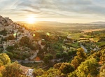
Explore Luberon, France
The Luberon is a massif in central Provence in Southern France, part of the French Prealps. It has a maximum elevation of 1,256 metres (4,121 ft) and an area of about 600 square kilometres (230 sq mi). It is composed of three mountain ranges (from west to east): Lesser Luberon (Petit Luberon), Greater Luberon (Grand Luberon) and Eastern Luberon (Luberon oriental). The... -
Explore Madonie Geopark, Sicily, Italy
The Madonie Regional Natural Park is an Italian regional park located in Sicily, between Palermo and Cefalù and covers 39,972 acres (161.76 km2; 62.46 sq mi). It includes the Madonie mountain range and some of the highest mountains in Sicily. The park has six mountains that are over 1,500 metres (4,900 ft) and many more that are over 1,000 metres (3,300 ft). Th... -
Explore Majella UNESCO Global Geopark, Abruzzo, Italy
The Maiella (or Majella) is a massif in the Central Apennines, in Abruzzo, central Italy. The mountain is located at the boundary between the provinces of Chieti, Pescara and L'Aquila. The highest peak is Monte Amaro at 2,793 m, the second-highest of the entire Apennine range. The massif is at the centre of the Maiella National Park. The Maiella is formed by a compact... -
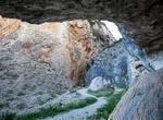
Explore Marble Arch Caves Global Geopark, Northern Ireland & Ireland
The Marble Arch Caves Global Geopark straddles the border between Northern Ireland and the Republic of Ireland. It is centred on the Marble Arch Caves and in 2001 it became one of the first geoparks to be designated in Europe. The Geopark features various sites which demonstrate the geological and wider natural heritage of the area, as well as the cultural heritage re...