Give us feedback!

Our philosophy is simple. We want to encourage you to dream. BIG! Then we help you plan your trip, get the most out of it while you're traveling and help you share your experience with friends.
Join Now It's FREE
Related Categories
Dreams Still To Do
Checked-Off Dreams
Dreams Still To Do
Checked-Off Dreams
Advertisement
Explore UNESCO Global Geopark
-
Explore Papuk Geopark, Croatia
Papuk is the largest mountain in the Slavonia region in eastern Croatia, near the city of Požega. It extends between Bilogora to the northwest, Krndija to the east, and Ravna gora and Psunj to the southwest. The highest peak is the eponymous peak at 953 m.a.s.l. The area of Papuk is designated a nature park (park prirode), a kind of protected area in Croatia. At the s... -
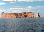
Explore Percé Geopark, Quebec, Canada
The UNESCO World Geopark of Percé (Géoparc de Percé) is located in Percé, a coastal village in the far east of the Gaspésie region, in the province of Quebec, Canada. The territory consists of 555 km2, which is 432 km2 of terrestrial area and 123 km2 of marine area. Its coastal landscape is dominated by coastal cliffs, including Bon... -
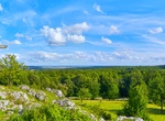
Explore Platåbergens UNESCO Global Geopark, Sweden
In West Sweden, the Platåbergens UNESCO Global Geopark covers an area of 3,690 km2and is home to 289,198 inhabitants. It presents a unique landscape of 15 flat-topped Table Mountains, platåbergen in Swedish, after which the site is named. These mountains were shaped by erosion during the last Ice Age 115,000 years ago. The area also covers the Västg&o... -
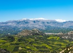
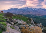
Explore Psiloritis Geopark, Crete
Psiloritis Natural Park is located in the island of Crete in southern Greece. Since 2001 the park is member of the European Geoparks Network and UNESCO Global Geoparks Network. It is a local authorities' initiative managed by the geopark's management committee under the AKOMM Psiloritis S.A.. The Natural History Museum of the University of Crete is the scientific coor... -
Explore Psiloritis Natural Park, Crete, Greece
Psiloritis Natural or Nature Park (GreekΦυσικό Πάρκο Ψηλορείτη)[i] is a UNESCO Global geopark located in the central part of the island of Crete, in southern Greece. Since 2001 the park is member of the European Geoparks Network, which is within the UNESCO Global Geoparks Netw... -
Explore Quarta Colônia Geopark, Brazil
Quarta Colônia Geopark is in the state of Rio Grande do Sul, Brazil. It protects an area of seasonal deciduous forest beside the dam of a hydroelectric power plant that started operation in 2001 on the Jacuí River. The park includes hills, cliffs and gentle or steep slopes. Altitudes range from almost 100 metres (330 ft) to over 4... -
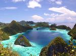
Visit Raja Ampat Geopark, Indonesia
Located off the northwest tip of Bird's Head Peninsula on the island of New Guinea, in Indonesia's West Papua province, Raja Ampat, or the Four Kings, is an archipelago comprising over 1,500 small islands, cays and shoals surrounding the four main islands of Misool, Salawati, Batanta and Waigeo, and the smaller island of Kofiau. Raja Ampat Regency is new regency which... -
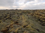
Explore Reykjanes Geopark, Iceland
Reykjanes is a small headland on the southwestern tip of Reykjanesskagi where the Mid-Atlantic ridge comes ashore in Iceland. Reykjanes Unesco Global Geopark is the second geopark in Iceland and the 66th member accepted into the European Geoparks Network in September 2015. The geopark is an area of 829 square kilometers, 0.85% of Iceland. There the Mid-Atlantic Ridge ... -
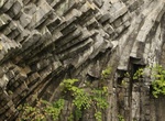
Explore Ries UNESCO Global Geopark, Germany
The Nördlinger Ries is an impact crater and large circular depression in western Bavaria and eastern Baden-Württemberg. It is located north of the Danube in the district of Donau-Ries. The city of Nördlingen is located within the depression, about 6 kilometres (3.7 mi) south-west of its centre. "Ries" is derived from Raetia, since the tribe of Raetians ... -
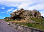
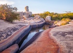
Explore Rocca di Cerere, Italy
The Rocca di Cerere UNESCO Global Geopark area is located in the central zone of Sicily Region and falls into the central southern belt of the Province of Enna. The Rocca di Cerere UNESCO Global Geopark is located on a gypsum-sulphur plateau with sandstone peaks. The UNESCO Global Geopark is characterized by its geological diversity. Geologically the area covers cent... -
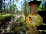
Explore Rokua Geopark, Finland
The Rokua region, also known as the Rokuanvaara region is a region known for its moraine and dunes. The region covers parts of the municipalities of Muhos, Utajärvi and Vaala in the province of Oulu in Finland. The Rokuanvaara formation was formed at the end of the Wisconsin glaciation period, when fine-grain soil was washed into the region by melting waters. In ... -
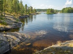
Explore Saimaa UNESCO Global Geopark, Finland, Finland & Russia
Saimaa is a lake in southeastern Finland. At approximately 4,400 square kilometres (1,700 sq mi), it is the largest lake in Finland, and the fourth largest natural freshwater lake in Europe. It was formed by glacial melting at the end of the Ice Age. Major towns on the lakeshore include Lappeenranta, Imatra, Savonlinna, Mikkeli, Varkaus, and Joensuu. The Vuoksi River ... -
Explore Salpausselkä UNESCO Global Geopark, Finland
Salpausselkä (Finnish: [ˈsɑlpɑu̯sˌselkæ]; "Bar Ridge") is an extensive ridge system left by the ice age in Southern Finland. It is a large terminal moraine formation that formed in front of the Baltic ice lake during the Younger Dryas period about 12,250–10,400 years ago. All together the formation is close to 500 km (310 mi) from end to end, and the ... -
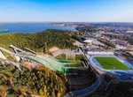
Explore San'in Kaigan Geopark, Japan
The San'in Kaigan Geopark is a geopark in Japan. The area was declared a Japanese Geopark in 2008, and a UNESCO Global Geopark in 2010. The underlying themes of the geopark are "geological features, the natural environment, people's lives, and the formation of the Sea of Japan". This geologically diverse area contains records of the process from when Japan was part of... -
Explore Seridó UNESCO Global Geopark, Brazil
The Seridó UNESCO Global Geopark covers an area of 2,800 km² in the semi-arid northeast of Brazil. It is home to more than 120,000 inhabitants, including communities like the Quilombolas, who keep alive the memory of their enslaved ancestors from Africa to preserve their culture through traditional practices, museums and cultural centres. The geopark bears...