Give us feedback!


 See all

Our philosophy is simple. We want to encourage you to dream. BIG! Then we help you plan your trip, get the most out of it while you're traveling and help you share your experience with friends.
Join Now It's FREE
Dream Packages
Duration: 13 hours 30 minutes
Price: $572.77
Price: $572.77
Duration: 3 hours 15 minutes
Price: $371.99
Price: $371.99
Duration: 12 hours
Price: $263.50
Price: $263.50
Duration: 6 days
Price: $606.00
Price: $606.00
Related Categories
- Australian National Parks & Reserves
- Canadian National Parks
- Canyoneering
- Day Hikes
- Guided Hikes
- In the Mountains
- Mountaineering
- Mountains
- New Zealand Great Walks
- New Zealand National Parks
- Parks & Reserves
- Rock Climbing
- South African National Parks
- UK National Parks
- UNESCO Parks & Preserves
- US Historical Parks (NHP)
Dreams Still To Do
Checked-Off Dreams
Dreams Still To Do
Checked-Off Dreams
Advertisement
Explore Hikes & Treks
-
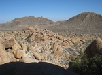
Hike Indian Hill, Anza-Borrego Desert State Park, California
Indian Hill is a 1,000 elevation gain hike located in Anza-Borrego Desert State Park. The hike through hillsides of teddy bear cholla and barrel cactus to the remains of a primitive 1912 railroad camp.From I-8, exit on S2 (Imperial Hwy.) at Ocotillo. Go northwest (left) on S2 for 8.7 miles, turning left onto Mortero Wash. 4WD or high-clearance vehicles are needed to r... -
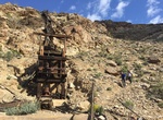
Hike to Indian Mine (Monarch Canyon Mine), Death Valley, California
This two-stamp mill is located in Monarch Canyon just below the Indian Mine (sometimes also called the Monarch Canyon Mine). First worked in the early 1900’s, this small gold mine contained ore originally assayed at $20 per ton. The one remaining iron stamp, built by Fairbanks & Morse, is imprinted with a patent date of November 29, 1904, and was used to con... -
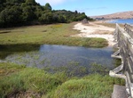
Hike Indian Nature Trail to Indian Beach, Tomales Bay State Park, California
Indian Beach is the northern beach in Tomales Bay State Park, California. The Indian Nature Trail starts at the Hearts Desire Beach restrooms. -
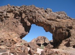
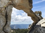
Hike to Indian Pass Arches, California
On the western edge of the Picacho Peak Wilderness is a trio of arches called the Indian Pass Arches. The trailhead is off Indian Pass Road and will take 2-3 hours. From Yuma, Arizona drive west on I-8 into California 20 miles to the Ogilby Road exit. Turn right and go north on Ogilby Rd. about 13 miles to Indian Pass Road. Turn a sharp right onto the gravel road a... -
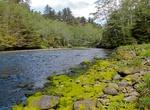
Hike Indian River Trail, Sitka, Alaska
This trail follows the Indian River winds through a densely wooded valley full of old growth conifers. The trailhead is at the end of Indian River Road (also an access point for the Sitka Cross Trail). About a mile in, the trail skirts a muskeg, and on a clear day there is a beautiful view of the Sisters Mountains. However, the main star of this trail is the forest it... -
Hike to Indian Rock, Yosemite National Park, California
Indian Rock is a unique granite arch found near the trail to North Dome. As the granite was slowly uplifted over time, cracks formed which allowed erosive forces, like ice wedging, to do their work. During winter, freezing temperatures caused the water in the tiny cracks to freeze and expand, eventually breaking pieces of rock away. Indian Rock used to be one solid bo... -
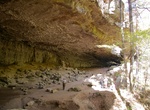
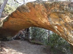
Hike Indian Rockhouse Trail, Buffalo National River, Arkansas
A hike on the Indian Rockhouse reveals geologic formations commonly found on a limestone landscape and gives hikers an opportunity to explore locations where ancient peoples sought shelter. -
Hike Indian Staircase Trail, Red River Gorge, Kentucky
Indian Staircase Trail is a 3.1 mile loop trail in Red River Gorge, Kentucky. The Staircase trail is a very special scenic area but the staircase itself is challenging for many. Be wary of bringing your pet up the staircase if they aren't used to climbing. -
Hike Inferno Cone, Craters of the Moon National Monument, Idaho
The trail to the top of Inferno Cone is steep, but rewards you with panoramic views of the Great Rift, Snake River Plain, and Pioneer Mountains. On clear days you may see the Teton Range, 100 miles to the east. Do not climb in high winds! You will be very exposed and the cinders are sometimes picked up by the wind. -
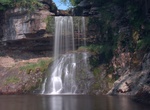
Hike Ingleton Waterfalls Trail, North Yorkshire, England
Ingleton Waterfalls Trail is a well-known circular trail beginning and ending in the village of Ingleton in the English county of North Yorkshire, now maintained by the Ingleton Scenery Company. It is claimed that the trail, some 8 kilometres (5 mi) long, and with a vertical rise of 169 m (554 feet) has some of the most spectacular waterfall and woodland scenery in th... -
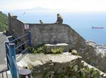
Hike Inglis Way, Gibraltar
Inglis Way is a footpath with a length of around 1,200 metres (3,900 ft) that traverses the middle section of the Upper Rock, linking various disused observation posts and emplacements. The origins of its name are uncertain; it may have been named after a person named Inglis, or it may have derived from an old Spanish name, el Camino del ingles, "the Englishman's Path... -
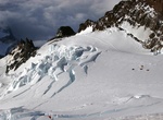
Climb Ingraham Glacier, Mount Rainier National Park
Ingraham Glacier is on the south-eastern flank of Mount Rainier, in the U.S. state of Washington. The glacier is named for the Mount Rainier enthusiast Edward Sturgis Ingraham. From the summit ice cap, Ingraham Glacier flows east between Gibraltar Rock, (12,660 ft (3,860 m)), and Disappointment Cleaver and south of Little Tahoma Peak (11,138 ft (3,395 m)), which divid... -
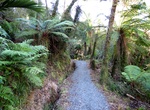
Hike Inland Pack Track, Paparoa National Park, New Zealand
Built in 1867 during the gold rush to avoid dangerous coastal travel, the Inland Pack Track gives access to some of the finest features of Paparoa National Park. There are no huts along the way, but there is sheltered camping under the Ballroom Overhang, where there is a toilet. Punakaiki River to Pororari River Time: 1 hrDistance: 3.5 km The Inland Pack Track tra... -
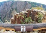
Hike Inner Canyons, Gunnison National Park, Colorado
While it’s possible to reach the river by Hiking the Inner Canyons of Gunnison National Park, it is also best to keep in mind there are no maintained or marked trails in the area. Routes are difficult to follow and only individuals in excellent physical condition should attempt these hikes. There are a number of routes to and along the river within the National ... -
Hike Inspiration Loop Trail, Santa Monica Mountains National Recreation Area, Southern California
The Inspiration Loop Trail provides a great opportunity to leave the hustle and bustle of Los Angeles and quickly escape into the Santa Monica Mountains. Thanks to the generous gift of Betty Rogers we can learn about the importance of Will Rogers and share his love of nature and mankind. In addition to touring the historic Ranch House and learning why Will is regarded...

Price: $289.36