Give us feedback!


 See all

Our philosophy is simple. We want to encourage you to dream. BIG! Then we help you plan your trip, get the most out of it while you're traveling and help you share your experience with friends.
Join Now It's FREE
Dream Packages
Duration: 10 hours
Price: $224.21
Price: $224.21
Duration: 10 hours
Price: $121.33
Price: $121.33
Duration: 2 days
Price: $398.24
Price: $398.24
Duration: 12 hours
Price: $224.21
Price: $224.21
Related Categories
- Australian National Parks & Reserves
- Canadian National Parks
- Canyoneering
- Day Hikes
- Guided Hikes
- In the Mountains
- Mountaineering
- Mountains
- New Zealand Great Walks
- New Zealand National Parks
- Parks & Reserves
- Rock Climbing
- South African National Parks
- UK National Parks
- UNESCO Parks & Preserves
- US Historical Parks (NHP)
Dreams Still To Do
Checked-Off Dreams
Dreams Still To Do
Checked-Off Dreams
Advertisement
Explore Hikes & Treks
-
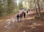
Hike Israel National Trail, Israel
The Israel National Trail is a hiking path that crosses the entire country of Israel. Its northern end is at Dan, near the Lebanese border in the far north of the country, and it extends to Eilat at the southernmost tip of Israel on the Red Sea, a length of 580-620 miles. The trail is marked with three stripes (white, blue, and orange), and takes an average of 45 days... -
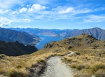
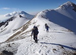
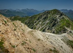
Hike or Mountain Bike Isthmus Peak Track, New Zealand
Walk or mountain bike this track to Isthmus Peak (1385 m) and cross the undulating skyline ridge. The track overlooks Lake Wānaka and Lake Hāwea, with great views of the Southern Alps/Kā Tiritiri o te Moana. Closed November to December – These tracks are annually closed for fawning between 20 November and 20 December. -
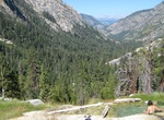
Hike to Iva Bell Hot Springs via Fish Creek Trail, California
Following the general route of an old wagon trail, the Fish Creek Trail starts near Reds Meadow Resort, shuttle stop # 10 or the Rainbow Falls trailhead shuttle stop #8. The trail passes multiple junctions with the John Muir, Devils Postpile and Rainbow Falls trails. The Fish Creek trail follows Crater Creek to the Fish Creek Valley. 11 miles down the trail is the pop... -
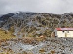
Hike to Ivory Lake Hut, New Zealand
New Zealand’s Ivory Lake Hut is a true gem. It is located next to the outlet creek of Ivory Lake at the head of the Waitaha valley. Access to Ivory lake is a challenge since the trail is not fully maintained. It's a basic six-bunk hut. A fit, experienced party needs to allow 2-3 days for the journey from the Waitaha roadend to Ivory Lake. Ivory Lake Hut is loc... -
Summit Iztaccíhuatl, Mexico
Iztaccíhuatl (alternative spellings include Ixtaccíhuatl) is the third highest mountain in Mexico, after the Pico de Orizaba (5,636 m) and Popocatépetl (5,426 m). Its name is Nahuatl for "White woman". The mountain has four peaks, the highest of which is 5,230 m (17,159 ft) above sea level. Together, the peaks are seen as depicting the head, chest... -
Hike Jacks Canyon Trail, Munds Mountain Wilderness, Arizona
Jacks Canyon Trail also meanders generally north–south, with significant east–west segments, for 6.5 miles (10.5 km) through the wilderness near Sedona and Oak Creek. It connects with the steep Munds Mountain Trail,from which the major Sedona-area rock formations and other landmarks in the region are visible. Munds Mountain Wildernessis an 18,150-acre (7,3... -
Hike to Jack's Walk to Morne Bruce, Roseau, Dominica
Jack's Walk begins in the Dominica Botanical Gardens. The trail was constructed in the 1880s during the establishment of the Botanic Gardens. Jack's Walk is a 15-minute steep climb, leading to the top of Morne Bruce. Morne Bruce is a hillside enclave located in Roseau, Dominica. It offers a panoramic view of the city and the Caribbean Sea beyond. The site was once hom... -
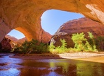
See Jacob Hamblin Arch (Lobo Arch), Coyote Gulch, Utah
Near the middle of Coyote Gulch canyon is Jacob Hamblin Arch (also known as Lobo Arch), large enough to reach under an overhang on the opposite side. It is only reachable by hiking Coyote Gulch. It is located within both the Grand Staircase-Escalante National Monument (upper sections) and the Glen Canyon National Recreation Area (lower sections). -
Climb Jacob's Ladder (Perth), Western Australia
Jacob's Ladder off Cliff Street is a popular venue for fitness enthusiasts in Perth, Western Australia. Jacob's Ladder is a set of stairs located at the end of Cliff Street, in the close proximity to Kings Park, though it is not part of the park. It has 242 steps and leads down to Mounts Bay Road. The Ladder is a popular site for Perth residents to exercise, with many... -
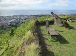
Climb Jacob's Ladder (Saint Helena), Saint Helena Island
Jacob's Ladder is a Grade I-listed staircase leading from Jamestown, Saint Helena, up the side of Ladder Hill to Ladder Hill Fort. The name is a reference to the biblical Jacob's Ladder, a ladder extending to heaven. The ladder is all that remains of a cable railway that was built there in the early 1800s. Its tracks and cars were later removed, although the stairs ha... -
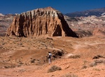
Hike Jailhouse Rock and Temple Rock Route, Capitol Reef National Park, Utah
The 4.5 miles (7.3 km) round trip Jailhouse Rock and Temple Rock Route starts at the Lower South Desert Overlook, where an old road leads to a viewpoint that overlooks Jailhouse Rock, a large promontory rising from the valley floor. To continue on to Temple Rock, follow the switchbacking track until it disappears along the valley floor. A faint single track then ... -
Hike Jakobshorn to Brämabüel, Devos, Switzerland
Hike between Jakobshorn and Brämabüel in Devos, Switzerland. -
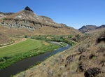
Hike James Cant Ranch River Trail, John Day Fossil Beds National Monument, Oregon
The River Trail (0.6 miles round trip) at James Cant Ranch is a packed gravel and mostly level trail leads to the John Day River from the Cant Ranch parking lot. -
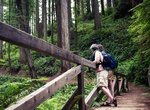
Hike James Irvine Trail, Prairie Creek Redwoods State Park, California
The quintessential redwood trail, this moderate hike travels along Godwood Creek through majestic forests to end at the world-famous Fern Canyon and Home Creek. You will easily spend 4-5 hours traveling through the enormous old-growth trees that line this historic access route to Gold Bluffs Beach mines and camps. After arriving at Fern Canyon, continue on the Coastal... -
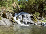
Hike James K. Carr Trail to Whiskeytown Falls, California
The steep, strenuous, and scenic James K. Carr Trail uses mostly former logging roads to get the the tallest waterfall in the park, Whiskeytown Falls, a three-tiered cascade of 220 feet. The trail starts out heading downhill. After crossing over the west fork of Crystal Creek on a small footbridge, the trail begins to climb, sometimes very steeply. Just 0.2 miles befo...

Price: $572.77