Give us feedback!


 See all

Our philosophy is simple. We want to encourage you to dream. BIG! Then we help you plan your trip, get the most out of it while you're traveling and help you share your experience with friends.
Join Now It's FREE
Dream Packages
Duration: 10 hours
Price: $121.33
Price: $121.33
Duration: 12 hours
Price: $160.26
Price: $160.26
Duration: 6 to 10 hours
Price: $86.83
Price: $86.83
Duration: 4 hours
Price: $129.99
Price: $129.99
Related Categories
- Australian National Parks & Reserves
- Canadian National Parks
- Canyoneering
- Day Hikes
- Guided Hikes
- In the Mountains
- Mountaineering
- Mountains
- New Zealand Great Walks
- New Zealand National Parks
- Parks & Reserves
- Rock Climbing
- South African National Parks
- UK National Parks
- UNESCO Parks & Preserves
- US Historical Parks (NHP)
Dreams Still To Do
Checked-Off Dreams
Dreams Still To Do
Checked-Off Dreams
Advertisement
Explore Hikes & Treks
-
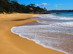
Visit Jibbon Beach Loop Track, Royal National Park, Sydney, Australia
The Jibbon Beach Loop Track is an easy walking trail from the Bundeena ferry wharf to Jibbon Head, Port Hacking Point and Shelley Beach. Jibbon Beach offers shady trees, this secluded beach features swimming, sunbathing, picnicking & sunset views. -
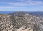
Summit Job’s Peak, Job’s Sister & Freel Peak, Lake Tahoe, California
Jobs Peak (10,600 feet), Job's Sister (10,700 feet) and Freel Peak (10,900 feet) are some of the highest peak in the Lake Tahoe area and is located in South Lake Tahoe. The summit offers spectacular view of Lake Tahoe and its surrounding mountains. -
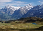
Hike Joch Pass, Switzerland
The Joch Pass (German:Jochpass) is a mountain pass of the Uri Alps, located between the Bernese Oberland and Central Switzerland, at the foot of the Titlis. The pass crosses the col between the peaks of Graustock and Jochstock, at an elevation of 2,207 m (7,241 ft) and at the border between the cantons of Bern and Nidwalden. The pass is traversed by a mule track, now ... -
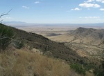
Hike Joe's Canyon Trail, Coronado National Memorial, Arizona
From the trailhead near the picnic area turnoff, 500 ft/150 m from west of the visitor center, the trail climbs about 1000 ft/300 m in the first mile with scenic views of Montezuma Canyon and the San Pedro River Valley. After reaching the saddle at the top of Smuggler's Ridge, the trail continues westward with southerly views deep into the grasslands of Sonora, Mexico... -
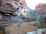
Hike Joffre Falls Trail, Karijini National Park, Western Australia
On the western side of the park is Joffre Gorge, a spectacular curved waterfall forming a natural amphitheatre. Especially impressive after rain, water cascades down the step-like cliff face to a dark pool and then, as the gorge narrows, the rushing, white waters tumble over smooth black rock. Follow the marked route into the bottom of the gorge to the first pool down... -
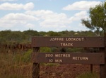
Hike Joffre Gorge, Karijini National Park, Western Australia
There is a short track from the carpark to the lookout overlooking the falls, which are usually dry, and the plunge pool at their base. A hike into the gorge is 3 kilometres, 3-hour return walk. Follow the marked route into the bottom of the gorge to the first pool downstream of the waterfall. The gorge has some nice waterfalls, deep pools and breath-taking views. Acc... -
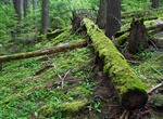
Hike John Muir Trail, California
The John Muir Trail (JMT) is a long-distance trail in the Sierra Nevada mountain range of California, running 211 miles (340 km) between the northern terminus at Happy Isles in Yosemite Valley and the southern terminus located on the summit of Mount Whitney. For almost all of its length, the trail is in the High Sierra backcountry and wilderness areas. For about 160 m... -
Hike John Muir Way, Lothian, Scotland
The John Muir Way is a 215-kilometre (130 mi) continuous long distance route in southern Scotland, running from Helensburgh, Argyll and Bute in the west to Dunbar, East Lothian in the east. It is named in honour of the Scottish conservationist John Muir, who was born in Dunbar in 1838 and became a founder of the United States National Park Service. The John Muir Way o... -
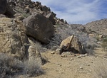
Hike to Johns Camp & Gold Hill Mine, Joshua Tree National Park, California
Johns Camp existed because of five claims collectively known as the Gold Hill Mine, located a little farther up the wash from the camp. The mine operated during the late 1920s and early 1930, and was owned by C.H. Wiser, Anvil B. Johns and J.A. Johns. I'm guessing the camp was named after one of the Johns. There's no trail to Johns Camp, but there is a fading dirt ro... -
Hike John's Canyon, Utah
Access to the lower end of John’s Canyon is via Utah Highway 261 from the turn off to Goosenecks State Park. One can drive the dirt road along the north rim of the San Juan River, up to a drill pad near the mouth of John’s Canyon. The upper part of John’s Canyon can be entered from a dirt road off Highway 261, via a side canyon just south of the dril... -
Hike John's Lake Trail, Glacier National Park, Montana
Johns Lake Loop is a 1.9 mile loop trail near Lake McDonald in Glacier National Park. -
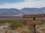
Off-road & Hike Johnson Canyon Road to Hungry Bill's Ranch, Death Valley National Park, California
Johnson Canyon is a fun side trail off West Side Road in Death Valley National Park. High-clearance is recommended for the first 6 miles which is pretty flat, but the last 4 miles require 4WD as it goes up the canyon. Last 0.1 mile of road is over-grown and very wet. Johnson Canyon Rd ends at a steep 2-mile hike leads to Hungry Bill's Ranch, with its rock-walled terra... -
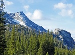
Summit Johnson Peak, Tuolumne Meadows, California
Johnson Peak is the highest mountain, in Tuolumne Meadows, Yosemite National Park. Johnson Peak is made of eroded granite. At 85 Ma, the Johnson Granite Porphyry is the youngest granite rock in the Yosemite National Park, though the entire peak formed beneath the Earth's crust. It broached the surface much later, via subduction. Despite it being a fairly easy hike, Jo... -
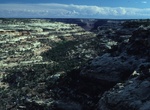
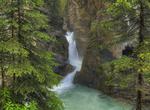
Hike Johnston Canyon & Waterfalls, Banff National Park, Canada
Johnston Creek is a tributary of the Bow River in Canada's Rocky Mountains located in Banff National Park. As Johnston Creek approaches the Bow River, it flows through a large canyon formed by erosion over thousands of years. The creek has cut through the limestone rock to form sheer canyon walls, as well as waterfalls, tunnels, and pools. This popular tourist attract... -
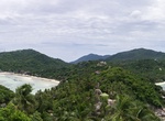
Hike to John Suwan Viewpoint, Ko Tao, Thailand
In order to reach the viewpoint you have to hike for 15-20 minutes in mediocre path. There are some rocks to climb but mostly there'll be ropes for extra support. You'll have to fight the sun and humidity too but once you're at the top you'll forget it all. The view is the best on the island!
Price: $154.81