Give us feedback!


 See all

Our philosophy is simple. We want to encourage you to dream. BIG! Then we help you plan your trip, get the most out of it while you're traveling and help you share your experience with friends.
Join Now It's FREE
Dream Packages
Duration: 10 hours
Price: $224.21
Price: $224.21
Duration: 30 minutes
Price: $263.77
Price: $263.77
Duration: 12 hours
Price: $263.50
Price: $263.50
Duration: 6 to 10 hours
Price: $86.83
Price: $86.83
Related Categories
- Australian National Parks & Reserves
- Canadian National Parks
- Canyoneering
- Day Hikes
- Guided Hikes
- In the Mountains
- Mountaineering
- Mountains
- New Zealand Great Walks
- New Zealand National Parks
- Parks & Reserves
- Rock Climbing
- South African National Parks
- UK National Parks
- UNESCO Parks & Preserves
- US Historical Parks (NHP)
Dreams Still To Do
Checked-Off Dreams
Dreams Still To Do
Checked-Off Dreams
Advertisement
Explore Hikes & Treks
-
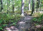
Hike Laurel Highlands Trail, Pennsylvania
Laurel Highlands Hiking Trail is 70 miles (110 km) long, begins at Ohiopyle State Park and ends at Conemaugh Gorge near Johnstown. The trail goes through state forests, state parks, state game lands, and some privately owned lands. Laurel Highlands Hiking Trail is open year round. The trail is marked with yellow blazes. Connector trails are marked with blue blazes. Th... -
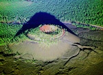
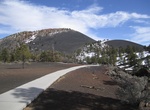
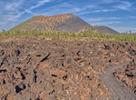
Summit Lava Butte, Newberry National Volcanic Monument, Oregon
Lava Butte is a cinder cone in central Oregon, United States, just west of U.S. Route 97 between the towns of Bend, Oregon, and Sunriver, Oregon. It is part of a system of small cinder cones on the northwest flank of Newberry Volcano, a massive shield volcano which rises to the southeast. The cinder cone is capped by a crater which extends about 60 feet (20 m) deep be... -
Hike Lava Cast Forest, Newberry National Volcanic Monument, Oregon
Lava Cast Forest is a visitor destination within the Newberry National Volcanic Monument near Bend, Oregon, of the United States. It is a geologic feature containing a 6,000 year old lava flow that created lava molds of ancient trees. It's located about 25 total miles south of Bend and is accessible via a 9-mile (14 km) gravel road from U.S. Highway 97. The site inclu... -
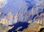
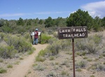
Hike Lava Falls Trail, Grand Canyon National Park, Arizona
The Lava Falls Trail is a strenuous 2 mi (3 km) hiking trail with 2,540 ft (770 m) elevation change on the North Rim of the Grand Canyon National Park. Take the rough road to Toroweap Overlook but turn right (West) a little of 2 miles from the overlook. It descends from the north rim of the Grand Canyon just west of the extinct volcano known as Vulcan's Throne to the ... -
Hike Lava Falls Trail, New Mexico
The Lava Falls Trail forms a one-mile loop with a short spur trail leading into a natural amphitheater of lava. This trail is marked by cairns, or rock piles that serve as trail markers. Although the trail is relatively short, its surface is very jagged and uneven. Hiking here with pets is not recommended. Picnic tables and the pit toilet are wheelchair accessible. P... -
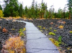
Hike Lava Flow Trail, Sunset Crater Volcano National Monument, Arizona
Explore the Bonito Lava Flow and numerous volcanic features while walking at the base of Sunset Crater Volcano. The upper 0.25 mi (0.5 km) loop has a concrete surface. -
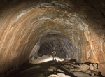
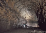
Explore Lava River Cave, Arizona
Lava River Cave is a lava tube cave in northern Arizona's Coconino National Forest. At approximately 0.75-mile (1.21 km) long, it is the longest cave of this kind known in Arizona. The cave was discovered by some lumbermen in 1915. The cave has also historically been referred to as "Government Cave" due to its location on the eastern edge of Government Prairie and sou... -
Hike Lava River Cave, Newberry National Volcanic Monument, Oregon
The Lava River Cave near Bend, Oregon, is part of the Newberry National Volcanic Monument, which is managed by the United States Forest Service. The cave is an excellent example of a lava tube. At 5,211 feet (1,588 m) in length, the northwest section of the cave is the longest continuous lava tube in Oregon. While the cave’s discovery in 1889 was officially cred... -
Hike Lava’s Edge Trail, Sunset Crater Volcano National Monument, Arizona
Walk under ponderosa pines, over loose cinders and rough basalt along the jagged edge of the Bonito Lava Flow. Note: Pets are only allowed on the U.S. Forest Service section of this trail, 2 mi (3.2 km) round-trip. Ask rangers at the visitor center for details. -
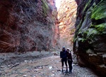
Hike La Verkin Creek Trail to Bear Trap Canyon, Zion National Park, Utah
The trail begins at Lee Pass and passes by the open finger canyons of the near-by cliffs as it travels along Timber Creek. After coming around the corner and within view of La Verkin Creek, the trail descends the slope down to the creek bottom on a hard packed trail. Once on the creek bed, the trail heads up stream offering amazing views of the surrounding cliffs. The... -
Hike La Verkin Creek Trail to the Kolob Arch, Zion National Park, Utah
The LaVerkin Creek Trail to the Kolob Arch allows hikers outstanding opportunities for solitude in a primitive area of Zion Wilderness. The trail begins at Lee Pass with stunning views of the Kolob Canyons as it crosses Timber Creek and continues to descend toward LaVerkin Creek. After seven miles a spur trail leads hikers to a viewpoint where they can see the Ko... -
Hike Lawson Peak Trail, San Diego, California
Lawson Peak Trail is a 4.3 mile out and back trail located near Jamul, California. It has a cave and a great place to hike and rock climb. The first two miles were on a gradual ascent on an old unkempt jeep-type road. The remain part of the trail is through boulders, brush, & rocks. -
Hike to La Zaplaz, Piatra Craiului Mountains, Romania
This is one of the most difficult hikes in Romania. La Zaplaz (The Fence) is a collapsed cave. Only a few short sections of the cave ceiling still exist. And they form a spectacular series of four natural bridges. -
Hike Leaf Hill Trail, John Day Fossil Beds National Monument, Oregon
The Leaf Hill Trail is 0.25 mile / 0.4 km roundtrip. Leaf Hill has been extensively excavated and studied by paleontologists. Interpretive signs along the trail explain more of its history. -
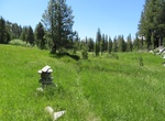
Hike Leavitt Meadows Trail, Mono County, California
Hike an easy-grade trail through this lush and sunny Eastern Sierra meadow. The Leavitt Meadows Trail leads up to several pine-surrounded lakes in about 6 miles (one way). Lane Lake is the most common day-hike destination (about 4 hours round trip). The area also encompasses Poore Lake, Roosevelt Lake and Secret Lake. The trailhead is located a half mile east on Highw...


Price: $341.00