Give us feedback!


 See all

Our philosophy is simple. We want to encourage you to dream. BIG! Then we help you plan your trip, get the most out of it while you're traveling and help you share your experience with friends.
Join Now It's FREE
Dream Packages
Duration: 12 hours
Price: $160.26
Price: $160.26
Duration: 4 days
Price: $1026.70
Price: $1026.70
Duration: 14 hours
Price: $341.00
Price: $341.00
Duration: 10 hours
Price: $121.33
Price: $121.33
Related Categories
- Australian National Parks & Reserves
- Canadian National Parks
- Canyoneering
- Day Hikes
- Guided Hikes
- In the Mountains
- Mountaineering
- Mountains
- New Zealand Great Walks
- New Zealand National Parks
- Parks & Reserves
- Rock Climbing
- South African National Parks
- UK National Parks
- UNESCO Parks & Preserves
- US Historical Parks (NHP)
Dreams Still To Do
Checked-Off Dreams
Dreams Still To Do
Checked-Off Dreams
Advertisement
Explore Hikes & Treks
-
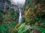
Hike to Levada das 25 Fontes & Risco, Madeira, Portugal
The Risco Waterfall ("Risco" meaning risk in English) is a group of waterfalls located in Rabaçal, Paul da Serra, in the Madeira Islands. The 25 Fontes levada name comes from the number of fountains or little waterfalls that’s possible to count once you arrive there. The Risco waterfall is 100m high, consisting of a group of different water streams comin... -
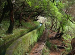
Hike along Levada Paths, Madeira
A levada (aka Levada do Rei or Kings Levada) is an irrigation channel or aqueduct specific to the Portuguese island of Madeira. The levadas originated out of the necessity of bringing large amounts of water from the west and northwest of the island to the drier southeast, which is more conducive to habitation and agriculture, such as sugar cane production. They were u... -
Hike or Bike Levee Trail, Ste. Geneviève, Missouri
Bike, walk, run, or roll on the 3.5 mile-long Levee Trail. You can get your heart pumping with the backdrop of the Mississippi River or enjoy a relaxed walk atop the levee while discovering nearby birds, plants and fish. From the Welcome Center turn right on Main Street. Follow Main Street for 0.5 miles, then turn right on to Division Street (AKA Stormy Crawford Wa... -
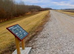
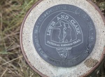
Hike Lewis and Clark National Historic Trail, Illinois to Oregon
The Lewis and Clark National Historic Trail is a route across the United States commemorating the Lewis and Clark Expedition of 1804 to 1806. It is part of the National Trails System of the United States. It extends for some 3,700 miles (6,000 km) from Wood River, Illinois, to the mouth of the Columbia River in Oregon. The trail is administered by the National Park Se... -
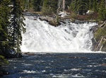
See Lewis Falls, Yellowstone National Park, Wyoming
The Lewis Falls are located on the Lewis River in Yellowstone National Park, Wyoming, United States. The falls drop approximately 30 feet (9.1 m) and are easily seen from the road, halfway between the south entrance to the park and Grant Village. The falls are on the Lewis River, just south of Lewis Lake. -
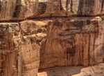
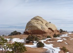
Hike to Lewis Lodge Ruins, Cedar Mesa, Utah
Lewis Lodge is a fortress perched on the edge of an 800-foot high cliff in a side canyon to Arch Canyon in Cedar Mesa are in Utah. It is one of the best Indian ruin on Cedar Mesa, Utah. ere are apporximately 44 rooms in the dwelling. The hike goes along some very exposed ledges, not good for kids or dogs. A short rope may be helpful for the hike. Note: The location ... -
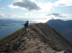
Summit Liathach (“The Grey One”), Northwest Highlands, Scotland
Liathach is a mountain in the Torridon Hills. At a height of 3,461 feet (1,055 m), it lies to the north of the A896 road, in the Northwest Highlands of Scotland, and has two peaks of Munro status: Spidean a' Choire Lèith at the east of the main ridge, and Mullach an Rathain at the western end of the mountain. The nameLiathachis pronounced [ˈʎiəhəx] in Scottish ... -
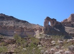
Hike Liberty Bell Arch Trail, Arizona
Want to ponder the Declaration of Independence and the ideals of freedom while you hike through the desert? We’ve got the trail for you. The Liberty Bell Arch trail has lots to see: pass an old mine, see the natural arch that looks like the Liberty Bell, and stand 700 feet above the Colorado River--all on one trail. Distance: 7 miles out and back How to Ge... -
Hike Liberty Cap Trail, Colorado National Monument, Colorado
Trail ascends steeply for 2 miles from the Grand Valley floor to Liberty Cap rock sculpture. Trail winds across gently sloping Monument Mesa through pinyon-juniper forest and sagebrush flats for the final 5.0 miles (8.0 km). There are 3 access points: from the west entrance, turn right onto Highway 340 (going east); continue 6.5 miles (10.5 km) and turn right at t... -
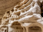
Hike Lick Wash, Grand Staircase-Escalante NM, Utah
Lick Wash is located in Grand Staircase-Escalante National Monument in southern Utah. The creek runs through a wash which in some sections narrows to become a slot canyon. Use Skutumpah Road, also known as BLM 500, to get to Lick Wash. -
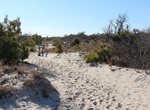
Hike Life of the Dunes Trail, Assateague Island National Seashore, Maryland
The Life of the Dunes Trail begins at the southern side of the South Beach parking lot in the Maryland district. This trail guides you through dune habitat, shrub thicket habitat, and along the remnants of Baltimore Boulevard. Baltimore Boulevard is the last physical reminder of a failed attempt of creating a resort community on Assateague. This ¾ mile walking... -
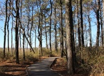
Hike Life of the Forest Trail, Assateague Island National Seashore, Maryland
The Life of the Forest Trail is a ½ mile walking trail that begins in the maritime forest with the potential of viewing reptiles, amphibians, and woodland birds. The trail then emerges out onto a boardwalk with gorgeous views of the Sinepuxent Bay and its marshes to the west, and the maritime forest to the east. The long boardwalk provides excellent birding opp... -
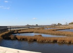
Hike Life of the Marsh Trail, Assateague Island National Seashore, Maryland
Treat yourself to extensive views to the south, west and north of the Sinepuxent Bay on this ½ mile walking Life of the Marsh Trail. This trail is comprised of a wooden boardwalk that transitions from the shrub thicket habitat in the parking lot, out to an elevated boardwalk over the marsh habitat. Herons, Egrets and Willets are just a few of the marshland bird... -
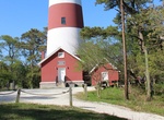
Hike Lighthouse Trail, Assateague Island National Seashore, Virginia
The unpaved ¼ mile round trip Lighthouse Trail winds through maritime forest leading up to the top of the 22 foot dune where the historic red and white striped Assateague Lighthouse and oil shed stands. The lighthouse is still in use and has a beacon call of two flashes every five seconds and can be seen miles away. While on the trail one can expect to hear son... -
Hike Light to Light Walk, Ben Boyd National Park, New South Wales, Australia
Experience the spectacular scenery of the state’s far south coast on the three-day Light to Light walk in Ben Boyd National Park. Light to Light walk hugs the coastline between historic Boyds Tower and Green Cape Lightstation. It’s one of the best walks on the far south coast of NSW.
Price: $779.00