Give us feedback!


 See all

Our philosophy is simple. We want to encourage you to dream. BIG! Then we help you plan your trip, get the most out of it while you're traveling and help you share your experience with friends.
Join Now It's FREE
Dream Packages
Duration: 2 days
Price: $398.24
Price: $398.24
Duration: 12 hours
Price: $263.50
Price: $263.50
Duration: 13 hours 30 minutes
Price: $572.77
Price: $572.77
Duration: 4 days
Price: $663.61
Price: $663.61
Related Categories
- Australian National Parks & Reserves
- Canadian National Parks
- Canyoneering
- Day Hikes
- Guided Hikes
- In the Mountains
- Mountaineering
- Mountains
- New Zealand Great Walks
- New Zealand National Parks
- Parks & Reserves
- Rock Climbing
- South African National Parks
- UK National Parks
- UNESCO Parks & Preserves
- US Historical Parks (NHP)
Dreams Still To Do
Checked-Off Dreams
Dreams Still To Do
Checked-Off Dreams
Advertisement
Explore Hikes & Treks
-
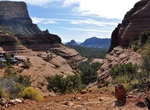
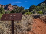
Hike Little Horse Trail to Chicken Point, Sedona, Arizona
The 3.4 mile roundtrip Little Horse Trail begins as part of theBell Rock Pathway trailhead (north). This easy to moderate trail that rolls across the Red Rock landscape through a number of dry creek washes (arroyos) and then crescendos atop Chicken Point. There are views of Cathedral Rock, Courthouse Butte, Bell Rock, Gibraltar Rock and the Munds Wilderness at the en... -
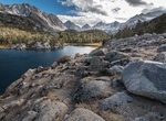
Hike Little Lakes Valley Trail to Gem Lakes, California
Little Lakes Valley Trail to Gem Lakes is a 6.9 mile out and back trail located near Bishop, California. The trailhead is at an elevation of 10000+ft, so acclimatization at high altitudes helps. It is one of the most scenic hike in the Eastern Sierra. It is a favorite for fall foliage. Dogs are allowed but must be kept on leash. -
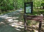
Hike Little Laurel Trail, New River, West Virginia
This strenuous trail connects Grandview with the New River 1,400 feet below. The trail follows an old road for two miles as it descends to the river, passing by the site of an old coal mine at Royal. The road descends steeply in some places with a total elevation change of around 1400 feet. This change in elevation provides an opportunity to view a great diversity of ... -
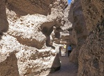
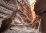
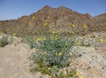
Hike Little Spooky Canyon, Arizona
If you’d like to get your spook on, this slot canyon hike is for you! Not especially scary unless you are claustrophobic, this hike is named for narrow slot canyons that were carved by rainwater and flash floods over time. Despite being located next to busy Highway 93, this dark and mysterious canyon is seldom visited. There are two separate slot canyons. Happy ... -
Summit Little Tahoma Peak, Mount Rainier National Park
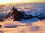
Little Tahoma Peak, also called Little Tahoma, is a satellite peak of Mount Rainier in Pierce County, Washington and in Mount Rainier National Park. It is quite noticeable from Seattle over 60 miles (97 km) away. Little Tahoma Peak is a volcanic remnant. It was once part of the larger structure of Mount Rainier but parts eroded away. The rock is quite unstable and in ... -
Hike Little Wild Horse & Bell Slot Canyons, Utah
Hiking the Little Wild Horse & Bell Canyons 8-mile loop is the most popular hike in the San Rafael Swell since the they are some of the best slot canyons in the area. They are easily explored and have narrow passages. The canyons can be hiked by themselves for a short distance or connected together to provide an easy half day loop hike. The canyons are 5 miles w... -
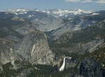
Hike Little Yosemite Valley, Yosemite National Park
Little Yosemite Valley is, as the name implies, a smaller glacial valley upstream in the Merced River drainage from the Yosemite Valley in Yosemite National Park. The Merced River meanders through the 3.5 mi (5.6 km) long flat valley, draining out over Nevada Fall and Vernal Fall before emptying into the main Yosemite Valley. It can be reached by a day hike from ... -
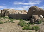
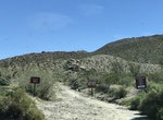
Hike to Live Oak Tank & Ivanpah Tank, Joshua Tree National Park, California
Start at Live Oak picnic area and hike down the wash to see if either Live Oak Tank or Ivanpah Tank holds any water behind them. Good chance if it has rained recently. -
Hike Living Desert Wilderness Loop, Palm Desert, California
The Living Desert Wilderness Loop hike begin inside the Living Desert Zoo and Gardens neaxt to Big Horn Sheep exhibit. Hikers traveling the loop clockwise will trek a mountain ridge, while those heading counter-clockwise traverse a rocky desert canyon. Both options lead to a pleasantly shaded picnic area. -
Off-road or Hike Lizard Canyon/Wash, Anza-Borrego Desert State Park, California
Lizard Canyon Trail is a moderate 2.8 mile out and back trail located between Julian and Borrego Springs along Route 78. Lizard Wash is usually a good bet for wildflowers just because it’s a wash. At at mile 0.8, the road forks with the main road, Lizard Canyon East Fork, continuing to the left. The rockier road, Lizard Canyon West Fork, heading right. The ... -
Hike or Mountain Bike Llama Trail, Sedona, Arizona
Although suitable for hiking, the Llama Trail is an alternate connector between the Little Horse Trail and Templeton trail for mountain bikers wishing to avoid the popular Bell Rock Pathway. The Llama Trail is marked at its intersection with the Little Horse Trail. There is a large dead pinion pine tree at the intersection. Before the Llama Trail was marked, bikers ca... -
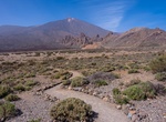
Visit Llano de Ucanca Vista Point, Tenerife Island, Canary Islands
Llano de Ucanca Vista Point offers great views on the Roques de Garcia and the Teide. There is a highing trail heading towards Roques de Garcia. -
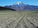
Summit Llullaillaco, Argentina & Chile
Llullaillaco is a potentially active stratovolcano at the border of Argentina (Salta Province) and Chile. It lies in the Puna de Atacama, a region of very high volcanic peaks on a high plateau within the Atacama Desert, one of the driest places in the world. It is the fourth highest volcano in the world, and it is also the seventh highest mountain of the Andes. Llulla... -
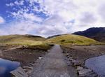
Hike Llŷn Coastal Path, Wales
The Llŷn Coastal Path is a waymarked 146 km (91 mi) long distance footpath running along the coast of the Llŷn Peninsula from Caernarfon to Porthmadog in Gwynedd, north-west Wales. A large part of the Llŷn Peninsula is designated an Area of Outstanding Natural Beauty. Devised and implemented by Gwynedd County Council and the Countryside Council for Wales, the path ope... -
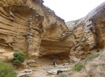
Hike Lobo Canyon, Santa Rosa Island, California
A spectacular canyon with wind- and water-sculpted sandstone cliffs, a year-round stream, riparian vegetation, and a spectacular coast at its mouth. Well worth the effort. It's 9 mile from the pier to the mouth of the canyon.
Price: $772.57