Give us feedback!


 See all

Our philosophy is simple. We want to encourage you to dream. BIG! Then we help you plan your trip, get the most out of it while you're traveling and help you share your experience with friends.
Join Now It's FREE
Dream Packages
Duration: 12 hours
Price: $154.81
Price: $154.81
Duration: 4 hours
Price: $129.99
Price: $129.99
Duration: 8 hours
Price: $214.32
Price: $214.32
Duration: 4 hours
Price: $149.99
Price: $149.99
Related Categories
- Australian National Parks & Reserves
- Canadian National Parks
- Canyoneering
- Day Hikes
- Guided Hikes
- In the Mountains
- Mountaineering
- Mountains
- New Zealand Great Walks
- New Zealand National Parks
- Parks & Reserves
- Rock Climbing
- South African National Parks
- UK National Parks
- UNESCO Parks & Preserves
- US Historical Parks (NHP)
Dreams Still To Do
Checked-Off Dreams
Dreams Still To Do
Checked-Off Dreams
Advertisement
Explore Hikes & Treks
-
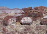
Hike Long Logs Trail, Petrified Forest National Park, Arizona
The Long Logs Trail in Petrified Forest National Park is a 1.6 mile loop that takes hiking by one of the largest concentrations of petrified wood in the park. The brilliant colors of the logs come from impurities in the quartz, such as iron, carbon, and manganese. The first half-mile of this trail is paved and suitable for mobility equipment and strollers. Strollers ... -
Visit Long Market (Długi Targ), Gdańsk, Poland
The Long Market (Długi Targ) in Gdańsk, Poland, is one of the most notable tourist attractions of the city. It is situated between the end of Long Lane (Ulica Długa) and Green Gate (Brama Zielona). Established in about 13th century, initially as a merchant road leading to the oval market place. Soon after bloody takeover of Gdańsk by Teutonic Knights, known as theGdań... -
Hike or Mountain Bike Long Pine Key Nature Trail, Everglades National Park, Florida
Connecting trails through the Pinelands run 7 miles (11 km) west from the Long Pine Key campground to Pine Glades Lake along the main park road. Many trails start around the Long Pine Key Campground, 7 miles (11 km) from the main park entrance/Ernest Coe Visitor Center. You may also park on road shoulders near the gates where trails meet paved roads. -
Hike Long Point Trail, New River, West Virginia
This trail traverses field and forest on the way to a rock outcrop (Long Point) with panoramic views of the gorge and New River Gorge Bridge. Most of this trail lazily descends through the forest, but it does include one steep section just before you arrive at the point. Impressive views of the New River Gorge, Wolf Creek drainage, and New River Gorge Bridge are avail... -
Summit Longs Peak, Rocky Mountain National Park, Colorado
Longs Peak is one of the 54 mountains with summits over 14,000 feet in Colorado. It can be prominently seen from Longmont, Colorado, as well as from the rest of the Colorado Front Range. It is named after Major Stephen Long, who explored the area in the 1820s. Longs Peak is one of the most prominent mountains in Colorado, rising up to 9,500 feet above the western edge... -
Hike Long Valley Discovery Trail, San Jacinto Mountain, California
The Long Valley Discovery Trail is located at the top of the Palm Springs Tram in the San Jacinto Mountains. This 3/4 mile (1.2 km) loop is a good introduction to the Park’s plants and animals. -
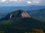
Summit Looking Glass Rock, North Carolina
Looking Glass Rock is a pluton monolith in the Appalachian Mountains of western North Carolina. The mountain is located within Pisgah National Forest about 5.5 miles (9 kilometers) northwest of Brevard and 25 miles (40 kilometers) southwest of Asheville. Named for the way its granite face reflects the sunshine, it rises from the valley floor to an elevation of almost ... -
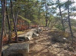
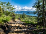
Hike Lookout Hills Trail, Gros Morne National Park, Newfoundland and Labrador
One of the best panoramic vistas in the national park awaits you at the top of this moderate trail. You’ll climb steadily through forest and then emerge from the trees onto a highland plateau. From the platform atop Partridgeberry Hill you can enjoy spectacular views of Bonne Bay, Gros Morne Mountain, the Tablelands and the Lookout Hills. A great spot for a phot... -
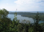
Hike to Lookout Louise, Isle Royale National Park, Michigan
From Hidden Lake to Lookout Louise is about 1.6 km (1 mi) long and 85 m (280 ft) up. -
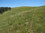
Hike Lookout Point Trail, Wind Cave National Park, South Dakota
Follow the rolling hills of the prairie then descent to Beaver Creek. This trail can be combined with parts of the Highland Creek and Centennial trails to make a 4.5-mile loop. The trail begins on the east side of Hwy 87, ½ mile north of its junction with Hwy 385. -
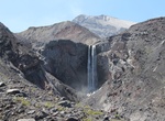
Hike Loowit Trail, Mount St. Helens, Washington
Loowit Trail #216 begins at the Ape Canyon Trail #234 junction and ends at the Windy Trail #216E junction. Wind around the east side of Mount St. Helens and enjoy views of the surrounding area. Travel over Windy Pass and then descend to the Pumice Plain. View miles of landscape transformed by the power of a volcanic eruption. This intermittently maintained trail t... -
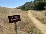
Hike or Mountain Bike Lopez Canyon Trail, San Diego, California
Lopez Canyon Trail run parallel to Penasquitos Canyon in San Diego, California. -
See Los Angeles River Cats, Los Angeles, California
In 1960's, long before graffiti became common everywhere in LA, people were painting cat faces on the storm drain covers along the L.A. River. Drain pipes in the Los Angeles River had covers that looked like cats, and were subsequently painted with cat faces. These have been painted and updated for decades along the cemented waterway’s 52-mile channel. The cats ... -
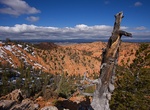
Hike or Ride Losee Canyon Trail, Red Canyon, Utah
Losee Canyon Trail #33090 travels along a wash that is bed lined on bothsides by stunning red rock formations and a mixed conifer forest. A round trip hike or bicycle ride is possible by going up Losee Canyon Trail to Cassidy Trail to Red Canyon Trailhead, then down the Red Canyon Bicycle Trail and up the Casto/Losee Road to the Losee Canyon Trailhead. This loop is a... -
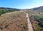
Hike or Mountain Bike Los Peñasquitos Canyon Preserve, San Diego, California
Los Peñasquitos Canyon Preserve is an urban park in San Diego, California. Stretching approximately 7 miles (11 km), the park encompasses some 4,000 acres (16 km2) of both Peñasquitos and Lopez canyons, and is one of the largest urban parks in the United States. There are trails on the south and north side of the creek along with severla crossing points ...


Price: $398.24