Give us feedback!


 See all

Our philosophy is simple. We want to encourage you to dream. BIG! Then we help you plan your trip, get the most out of it while you're traveling and help you share your experience with friends.
Join Now It's FREE
Dream Packages
Duration: 14 hours
Price: $341.00
Price: $341.00
Duration: 4 days
Price: $1026.70
Price: $1026.70
Duration: 4 hours
Price: $129.99
Price: $129.99
Duration: 4 days
Price: $772.57
Price: $772.57
Related Categories
- Australian National Parks & Reserves
- Canadian National Parks
- Canyoneering
- Day Hikes
- Guided Hikes
- In the Mountains
- Mountaineering
- Mountains
- New Zealand Great Walks
- New Zealand National Parks
- Parks & Reserves
- Rock Climbing
- South African National Parks
- UK National Parks
- UNESCO Parks & Preserves
- US Historical Parks (NHP)
Dreams Still To Do
Checked-Off Dreams
Dreams Still To Do
Checked-Off Dreams
Advertisement
Explore Hikes & Treks
-
Hike Lover’s Lane Loop Trail, Olympic National Park, Washington
Lover’s Lane Loop is a 5.8 mile loop connecting Sol Duc campground, Sol Duc Falls and the Resort. -
Hike or Kayak to Lovers Leap, Pictured Rocks National Lakeshore, Michigan
Lovers Leap is located aloing the Lakeshore-North Country Trail in Pictured Rocks National Lakeshore. The rock formation on the colorful cliff-lined Lake Superior coast features a huge sandstone arch. The most photographed place in the Pictured Rocks. Fun to paddle through. -
Hike to Lover's Leap along Appalachian Trail, Hot Springs, North Carolina
At Hot Springs, North Carolina, hike the Appalachian Trail by climbing to beautiful views from Lovers Leap and exploring the wide, whitewater-filled French Broad River. -
Hike Love Valley, Göreme Historical National Park, Cappadocia, Turkey
Love Valley (Aşıklar Vadisi) is a valley in Göreme Historical National Park, Cappadocia, Turkey. It is known for its rock formations called fairy chimneys. The history of Love Valley dates back to at least Roman times. There goes a legend that there once was two dynasties living in the same village. A fight broke out between the two dynasties, which resulted in t... -
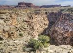
Canyoneer Lower Black Box, San Rafael Swell, Utah
The Lower Black Box is along the San Rafael River has carved a deep narrow slot canyon into the heart of the San Rafael Swell. It has 400 feet high and in places only 25 feet wide. PThe hike takes 7-7 hours and usually means in the water for 4 hours, so plan on being wet and cold. Many people use an inflated inner tube to float through the deep-water sections of the ... -
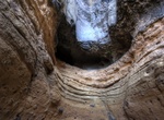
Hike Lower Burro Mesa Pour-off Trail, Big Bend National Park, Texas
This route starts at the end of a side road off Ross Maxwell Scenic Drive and follows an easy trail to the top of the 100-foot Burro Mesa Pour-off. Trail subject to flash flooding. -
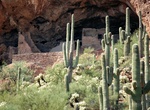
Hike to Lower Cliff Dwelling, Tonto National Monument, Arizona
The Lower Cliff Dwelling trail is open daily (closed December 25) from 8:00 a.m. to 4:00 p.m.You must start your hike before 4:00 pm.During the months of June, July and August,start your hike before 12 pm (noon).The trail is 1 mile (1.6 km) roundtrip and takes about one hour to complete. -
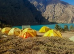
Trek Lower Dolpo Circuit, Nepal
The Lower Dolpo Circuit is a 220km trek in the Himalayas that winds through the southerly reaches of Dolpo. It is a quiet and less-crowded trek, with fewer trekkers compared to other treks in Nepal. The trek starts from Dunai Palchekhola. The trek takes about fourteen days. A mixture of tent camping and staying in tea houses as lodges (which are simple). Best Time: ... -
Hike Lower Emerald Pools Trail, Zion National Park
The Emerald Pools Trail begins at the Zion Lodge westward to Lower Emerald Pool. The trail was individually listed on the National Register of Historic Places on February 14, 1987. The trail to Lower Emerald Pool is an easy 1.2 mile (1.9 km) out and back hike. To continue on to Upper Emeral Pool is a moderate hike that is an additional 1.0 mile (1.6 km). -
Hike Lower Fish Creek Trail, Comb Wash, Utah
Great hike out to the Anasazi ruins and rock art sites. The upper reaches are best explored from the west, via Hwy 261, the lower section is accessed via the unpaved but good quality Comb Wash Road, running between Hwy 95 and US 163. Some ruins take a little scrambling to reach, and a few sections of the canyon floor have thick undergrowth. -
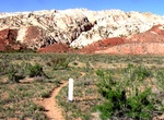
Hike Lower Hackberry Narrows, Grand Staircase-Escalante National Monument
Hackberry Canyon is a moderately difficult hike is one of the more scenic and popular canyon routes in the western half of the Grand Staircase-Escalante National Monument, Utah. Hackberry Canyon is one of the most popular of the Cottonwood Canyon Road hikes, and it is done generally one of two ways. The first is as a dayhike into the lower part of Hackberry Canyon, an... -
Hike Lower Harbor Trail, Schoodic Peninsula, Acadia National Park, Maine
Lower Harbor Trail is aneasy, 1.5 miles (2.4 km) trail in Schoodic Peninsula, Acadia National Park, Maine. Following the coastline this trail wanders through pine forests, offering the possibility of viewing sea birds. -
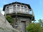
Hike Lower Mount Cammerer Trail, Great Smoky Mountains National Park, Tennessee
The Lower Mount Cammerer Trail is a hiking trail in the Great Smoky Mountains National Park of Cocke County, Tennessee. The trail ascends Mount Cammerer (elev. 4,928 ft (1,502 m); 1,502 m), leading (via a connection with the Appalachian Trail) to a small, untraditional firetower at the summit, from which panoramic views of Cocke County, the main range of the Grea... -
Hike Lower Muley Twist Canyon, Capitol Reef National Park
Lower Muley Twist Canyon in Capitol Reef National Park offers many options for side trips and off-trail exploring. The 6 mile (9.7 km) one way hike is in a deep, narrow, twisting canyon with large alcoves. Leave a vehicle at each end. From 1881 to 1884, the canyon served as a wagon route for Mormon pioneers traveling south toward San Juan County. The canyon was though... -
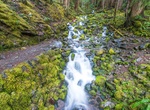
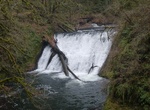
Hike to Lower North Falls, Silver Falls State Park, Oregon
Lower North Falls, is a 30 feet (9.1 m) tall waterfall located in the Silver Falls State Park at the east end of the city of Salem, in Marion County, in the U.S. state of Oregon. It is located in a privileged area on the west foothills where Mount Hood National Forest meets with the Middle Santiam Wilderness. Several prominent waterfalls are located in the Park along ...


Price: $86.83