Give us feedback!


 See all

Our philosophy is simple. We want to encourage you to dream. BIG! Then we help you plan your trip, get the most out of it while you're traveling and help you share your experience with friends.
Join Now It's FREE
Dream Packages
Duration: 4 hours
Price: $129.99
Price: $129.99
Duration: 4 hours
Price: $129.99
Price: $129.99
Duration: 12 hours
Price: $224.21
Price: $224.21
Duration: 2 days
Price: $469.00
Price: $469.00
Related Categories
- Australian National Parks & Reserves
- Canadian National Parks
- Canyoneering
- Day Hikes
- Guided Hikes
- In the Mountains
- Mountaineering
- Mountains
- New Zealand Great Walks
- New Zealand National Parks
- Parks & Reserves
- Rock Climbing
- South African National Parks
- UK National Parks
- UNESCO Parks & Preserves
- US Historical Parks (NHP)
Dreams Still To Do
Checked-Off Dreams
Dreams Still To Do
Checked-Off Dreams
Advertisement
Explore Hikes & Treks
-
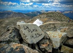
Summit La Plata Peak, Sawatch Range, Colorado
La Plata Peak is the fifth-highest summit of the Rocky Mountains of North America and the U.S. state of Colorado. The prominent 14,343-foot (4,372 m) fourteener is located in the Collegiate Peaks Wilderness of San Isabel National Forest, 22.7 miles (36.5 km) northwest by west (bearing 308°) of the Town of Buena Vista in Chaffee County, Colorado, United States. "La... -
Hike La Quinta Cove to Lake Cahuilla, La Quinta, California
The La Quinta Cove to Lake Cahuilla is hike is 6 miles out and back and takes about 2-2.5 hours. You can continue to Boo Hoff Trail and make the full loop back at a total of 12.7 miles. Go in the morning, before it gets too hot, and bring plenty of water and sun protection. From Hwy 111 take Washington (South) 3 miles to Avenue 52 (Turn Right) Take Avenue 52 a 1/2 mil... -
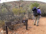
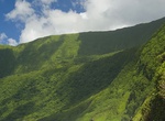
Trek Larapinta Trail, Australia
The Larapinta Trail is an extended walking track in the Northern Territory, Australia. Its total length covers 223 kilometres (139 mi) from East to West, with one end at Alice Springs and the other at Mount Sonder, one of the territory's highest mountains. It follows the West MacDonnell Ranges, sometimes along the ridge line, other times on the plain below, in the Wes... -
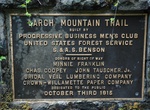
Hike Larch Mountain Trail, Oregon
The Larch Mountain Trail #441 begins near the Columbia River at the Multnomah Falls Lodge and roughly follows Multnomah Creek, passing severalwaterfalls including the well-known Multnomah Falls, Weisendanger Falls, and Ecola Falls. The trail ends at the Larch Mountain parking lot, at a picnic area. -
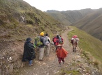
Hike Lares and Royal Inca Trail, Cusco, Peru
Avoid the crowds on and head off the beaten track on the Lares Trek—a great alternative to the Inca Trail. The Lares trek is a two or three day high altitude hike in Cusco, Peru, starting near the village Lares, approximately 40 miles north of Cusco and 35 miles east of Machu Picchu. The Lares Valley lies in the east of the Urupampa mountain range, traversing pa... -
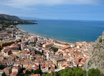
Hike La Rocca di Cefalù, Cefalù, Sicily, Italy
Hike to Castello Di Cefalù to see views of Cefalù, Sicily, Italy, -
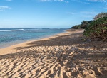
Hike to Larsen's Beach (Ka'aka'aniu Beach), Kauai, Hawaii
Larsen's Beach (aka Ka'aka'aniu Beach) is a remote and narrow 2 mile long beach on the north shore of Kauai, Hawaii. There is a offshore reef that is good for snorkeling. Since the beach is so remote, you may see some nude sunbathers. The current and reef make the beach not that safe to swim. Be very careful swimming and snorkeling. Access to the beach is along K... -
Summit La Soufrière, Saint Vincent
La Soufrière (“The Sulfurer”) or Soufrière Saint Vincent is an active volcano on the island of Saint Vincent in the Windward Islands of the Caribbean. At 1,234 m (4,049 ft), La Soufrière is the highest peak on Saint Vincent as well as the highest point in the island country of Saint Vincent and the Grenadines. The hike is a strenuous c... -
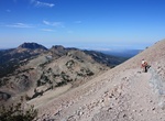
Summit Lassen Peak, Lassen Volcanic National Park, California
Lassen Peak, also known as Mount Lassen, is the southernmost active volcano in the Cascade Range. It is part of the Cascade Volcanic Arc which is an arc that stretches from southwestern British Columbia to northern California. Located in the Shasta Cascade region of Northern California, Lassen rises 2,000 ft (600 m) above the surrounding terrain and has a volume of 0.... -
Hike Las Vegas Wetlands Trail, Nevada
To hear the sound of running water or check out the birds and other wildlife that hang out near the wash, head to the Las Vegas Wetlands Trail. It might not be much to look at, and the water isn’t safe for swimming (being that it’s urban runoff), but for those of you searching for birding or river sounds close to Las Vegas, this is your spot. Distance:... -
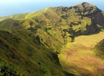
Summit Lata Mountain, Ta’u, American Samoa
Lata Mountain is the highest point of American Samoa, on the island of Ta'u. The trail from Saua around Si’u Point leads to the southern coastline of where rocky coast and sea cliffs stairstep to the 3,000 foot summit. -
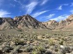
Hike or Ride Late Night Trail, Red Rock Canyon National Conservation Area, Nevada
Mule trains, loaded with trade goods, crossed this mountain pass in the mid-1800s on their long journey between Los Angeles, California and Santa Fe, New Mexico. Though the going was rugged, the area’s streams and springs provided essential water sources to traders and livestock making the route passable. Today, visitors can experience a little bit of what this ... -
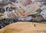
Hike Laugavegur (Laugavegurinn) Trail, Landmannalaugar, Iceland
The Laugavegur (or Laugavegurinn) is a famous trekking route in South-West Iceland from the hot springs area of Landmannalaugar to the glacial valley of Thórsmörk (Þórsmörk). It is noted for the wide variety of landscapes that are experienced in just 55 km (34 mi). The route is typically completed over 2–4 days with potential stops ... -
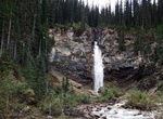
Hike to Laughing Falls, Yoho National Park, Canada
Take a 8.8 km (3 hours) forested trail to Laughing Falls at the confluence of the Yoho and Little Yoho Rivers. This trail leads to the Laughing Falls backcountry campround and is an access point for popular multiday backpacking routes. Take the Iceline Trail from Takakkaw Falls parking lot, 17 km east of Field via the Trans-Canada Highway and Yoho Valley Road. NOTE:... -
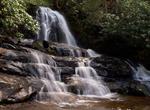
Hike Laurel Falls Trail, Great Smoky Mountains National Park, Tennessee
NOTE: Laurel Falls Trail is closed as of Jan. 6, 2025 for 18 months of rehabilitation work. The Laurel Falls Trail is located in the Great Smoky Mountains National Park, Tennessee. The trail ascends Cove Mountain (elev. 4,077 ft (1,243 m); 1,372 m), leading past Laurel Falls, one of the most popular waterfalls in the national park, en route to the summit of Cove Mount...


Price: $214.32