Give us feedback!


 See all

Our philosophy is simple. We want to encourage you to dream. BIG! Then we help you plan your trip, get the most out of it while you're traveling and help you share your experience with friends.
Join Now It's FREE
Dream Packages
Duration: 10 hours
Price: $199.57
Price: $199.57
Duration: 4 days
Price: $772.57
Price: $772.57
Duration: 4 days
Price: $1457.59
Price: $1457.59
Duration: 6 days
Price: $606.00
Price: $606.00
Related Categories
- Australian National Parks & Reserves
- Canadian National Parks
- Canyoneering
- Day Hikes
- Guided Hikes
- In the Mountains
- Mountaineering
- Mountains
- New Zealand Great Walks
- New Zealand National Parks
- Parks & Reserves
- Rock Climbing
- South African National Parks
- UK National Parks
- UNESCO Parks & Preserves
- US Historical Parks (NHP)
Dreams Still To Do
Checked-Off Dreams
Dreams Still To Do
Checked-Off Dreams
Advertisement
Explore Hikes & Treks
-
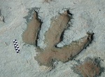
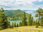
Hike Mill Canyon Dinosaur Trail, Moab, Utah
Mill Canyon Dinosaur Trail is a 1.8 mile out and back trail located near Moab, Utah. Self guided trail with informative signs. Remnants of an old copper mill can be seen on the south side of the canyon. To reach the Mill Canyon Dinosaur Trailhead, drive 15 miles north of Moab on U.S. 191, then turn left at an intersection just north of highway mile marker 141. Cross... -
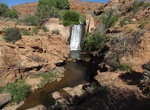
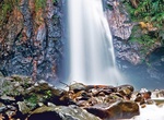
Hike Mill Creek Waterfall Trail, Moab, Utah
Mill Creek Trail is a 1.8 mile out and back trail located near Moab. It has several small waterfalls with swimming areas. -
Hike Miller Point Trail, Cathedral Gorge State Park, Nevada
Moderate canyon trail with stairs to Miller Point. -
Hike to Millomeris Waterfall, Troodos Mountains Geopark, Cyprus
It's a short hike to the highest and most beautiful waterfall of Cyprus. Millomeris (Myllomeris) Waterfalls Trail (1.2 km / 0.8 miles long each way) at an elevation of almost 1,000 m offers quite a different environment (eg plane trees, strawberry trees, violas, brambles, bracken, trout if walkers are lucky, etc). It runs in a lush valley and ends at the highest water... -
Hike to Milton (Syndicate) Falls, Dominica
The Milton (Syndicate) Falls is located on the island of Dominica in the West Indies in deep rainforest. -
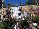
Hike to Minaret Falls, California
Minaret Falls is located on the Minaret Creek. It plunges over a granite rock buttress just before it enters the Middle Fork of the San Joaquin River. From Upper Soda Springs Campground take the bridge across the river and head south on the River Trail/Pacific Crest Trail. In less than 2 miles the trail crosses Minaret Creek at the base of the waterfall. -
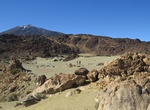
Hike Minas de San José, Tenerife Island, Canary Islands
Minas de San José is the last viewpoint along TF-21 road before starting to descend towards La Orotava. This rugged landscape is made up of lava and dark-colored rocks, a huge expanse of flat, light-colored land that looked like sand. Good place to see wildflowers in the right time of the year. -
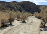
Off-road or Hike Mine Canyon, Anza-Borrego Desert State Park, California
Hike into the North Pinyon Mountains, the site of many desert mine locations. Visit a large Kumeyaay village site with hundreds of agave-roasting pits. The trail continues south from the village site, gently climbing into Mine Canyon and the Pinyon Mountains. Total elevation gain is 1,400 feet. From I-8, exit north on Hwy. 79 through Cuyamaca Rancho State Park to Jul... -
Hike Mineral Ridge Trail, Idaho
The 3.3-mile loop Mineral Ridge Trail in Idaho Panhandle National Forest offers great views of Lake Coeur d’Alene and the Coeur d’Alene mountains. -
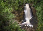
Hike to Miners Falls, Pictured Rocks National Lakeshore, Michigan
The Miners Falls parking lot is located about four miles north of H-58 off Miners Castle Road. The hike from the parking area to the waterfall is 1.2 miles round-trip. A gravel path through the northwoods leads to two overlooks. Enjoy the Miners Falls Nature Trail and views of the Miners Basin along the way. The Miners River drops about 50 feet over a sandstone outcr... -
Hike Miners Ridge Trail, Prairie Creek Redwoods State Park, California
Miners Ridge Trail follows the route used by gold miners in the mid-1800s. It follows a ridgeline that allows the heart to pump, and offers breathtaking views of coastal forest and steep ocean bluffs. 4.1 Mile trail -
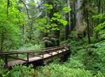
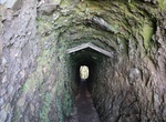
Hike Miners Tunnel Track, Westland Tai Poutini National Park, New Zealand
This 3.4-mile out-and-back track passes Gillespies Lagoon and leads to a tunnel that was built to provide an all-tide access route for miners. From the lagoon boardwalk, follow the track up the small incline until you see the tunnel. This 30-metre tunnel was blasted through the sea cliffs to give the miner’s access to their claims whatever the weather, or the ti... -
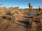
Hike Minerva Hoyt Trail, Joshua Tree National Park, California
Few park visitors give much thought to how national parks are established, but dedicated park boosters will probably mention the names of Ferdinand Hayden (Yellowstone), John Muir (Yosemite), and Enos Mills (Rocky Mountain) when asked to name people who promoted the founding of national parks. These were outdoorsmen in keeping with the rugged and heroic western landsc... -
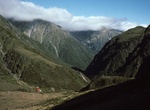
Trek Mingha - Deception Route, Arthur's Pass National Park, New Zealand
The Mingha - Deception Route in Arthur's Pass National Park is a classic traverse of the Southern Alps, crossing over Goat Pass. This trip is suitable for well-equipped people with previous backcountry tramping experience. The route can be walked from the east or west. Travel up the Deception River will require up to 30 compulsory river crossings. Both the Deception ... -
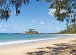
Hike from Minnie Water To Wooli, Yuraygir National Park
Along the 4-day coastal track in Yuraygir National Park through striking coastal scenery.
Price: $121.33