Give us feedback!


 See all

Our philosophy is simple. We want to encourage you to dream. BIG! Then we help you plan your trip, get the most out of it while you're traveling and help you share your experience with friends.
Join Now It's FREE
Dream Packages
Duration: 12 hours
Price: $160.26
Price: $160.26
Duration: 4 days
Price: $663.61
Price: $663.61
Duration: 4 hours
Price: $129.99
Price: $129.99
Duration: 6 days
Price: $606.00
Price: $606.00
Related Categories
- Australian National Parks & Reserves
- Canadian National Parks
- Canyoneering
- Day Hikes
- Guided Hikes
- In the Mountains
- Mountaineering
- Mountains
- New Zealand Great Walks
- New Zealand National Parks
- Parks & Reserves
- Rock Climbing
- South African National Parks
- UK National Parks
- UNESCO Parks & Preserves
- US Historical Parks (NHP)
Dreams Still To Do
Checked-Off Dreams
Dreams Still To Do
Checked-Off Dreams
Advertisement
Explore Hikes & Treks
-
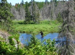
Hike Minong Ridge Trail, Isle Royale National Park
The Minong Ridge Trail runs 23 miles along the northern edge of Isle Royale National Park and usually takes 3-4 days to complete. It is considered to be a much tougher trail than the more popular Greenstone Ridge Trail and is considered the most challenging stretch of the Isle Royale’s 161-mile trail system due to the rough terrian and all the up and down hiking... -
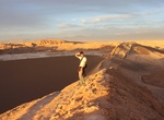
Hike to Mirador Achaches, Valle de la Luna, Chile
Hike up to Mirador Achaches for a great view of Valle de la Luna. The view of the off main road trail is peaceful and stunning but lots of tours go here. -
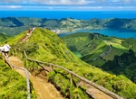
Hike to Miradouro da Boca do Inferno, São Miguel Island, Azores, Portugal
Photogenic footpath featuring trails & stunning views of a massive crater lake at Sete Cidades. -
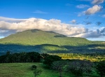
Hike Miravalles Volcano, Costa Rica
Miravalles Volcano is an andesitic stratovolcano in Costa Rica. The caldera was formed during several major explosive eruptions that produced voluminous dacitic-rhyolitic pyroclastic flows between about 1.5 and 0.6 million years ago. The only reported historical eruptive activity was a small steam explosion on the SW flank in 1946. High heat flow remains, and Miravall... -
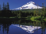
Hike to Mirror Lake (Mt Hood), Oregon
Mirror Lake is a mountain lake in Clackamas County of the U.S. state of Oregon. It is located at the foot of Tom Dick and Harry Mountain in a natural catchment formed by a toe of the mountain, 11.4 kilometres (7.1 mi) southwest of Mount Hood, and 3.1 kilometres (1.9 mi) WSW of Government Camp within Mount Hood National Forest. It is among the most popular day hikes in... -
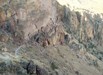
Hike Misery Ridge Trail, Smith Rock State Park, Oregon
Misery Ridge Trail goes from Crokked River bridge up to the 3,360 foot summit. The .68 mile trail to the summit takes off directly across from the bridge. You soon meet up with climbers on Picnic Lunch Wall after a series of small switchbacks. Continuing up, you pass Ship Rock and another favorite climbing destination, the Red Wall. -
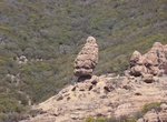
Hike Mishe Mokwa Trail to Split Rock, Westlake Village, California
Traversing riparian, coastal sage scrub, and chaparral, this trail offers wonderful views of Carlisle Canyon and Balanced Rock. Split Rock’s oak grove offers a shaded spot for picnicking. Trailhead is at Circle X Ranch. -
Trek to Misión San Pedro Mártir de Verona, Baja California
Mission San Pedro Mártir was established by the Dominican missionary José Loriente on 27 April 1794, in the Sierra San Pedro mountain range in northern Baja California, Mexico. San Pedro Mártir is one of only two California missions not accessible by automobile. A two or three day backpack hike or mule ride is required to reach the site. The usual... -
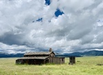
Hike Missing Cabin Trail, Valles Caldera National Preserve, New Mexico
This 0.5-mile (0.8 km) out-and-back trail climbs a small hill to an old movie set cabin nestled in a picturesque setting with excellent views of Valle Grande, South Mountain, and Hidden Valley. -
Hike to Mission, Sunrise & Gold Rose Wells, Joshua Tree National Park, California
Old Dale Road and Pinto Basin has three wells, once an important water sources for the mines and the people who traveled the area. Start the drive at the dirt Old Dale Road turn off from the paved Pinto Basin Road in Joshua Tree National Park. Mission Well stopping point is 9.7 miles down Old Dale Road. It's about 2.6 miles out and back hike to all 4 sites. Drive ab... -
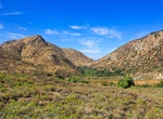
Explore Mission Trails Regional Park, San Diego, California
Mission Trails Regional Park is a 5,800-acre (23 km2) open space preserve within the city of San Diego, California, established in 1974. It is the sixth-largest municipally owned park in the United States, and the largest in California. The park consists mostly of rugged canyons and hills, with both natural and developed recreation areas, including many beautiful flow... -
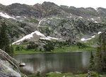
Hike Missouri Lakes Trail, Colorado
Missouri Lakes Trail is is located in the Holy Cross Wilderness in Colorado's the Rocky Mountains, south of Mount of the Holy Cross in Eagle County. The Missouri Lakes trail is 4.4 miles long. It begins at Missouri Creek Road #704 and ends at Cross Creek Trail and Fancy Pass Trail #2006: The first mile of the trail passes diversion dams and water pipelines. Just past... -
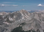
Summit Missouri Mountain, Colorado
Missouri Mountain is a high mountain summit in the Collegiate Peaks of the Sawatch Range of the Rocky Mountains of North America. The 14,074-foot (4,290 m) fourteener is located in the Collegiate Peaks Wilderness of San Isabel National Forest, 15.2 miles (24.5 km) northwest by west (bearing 302°) of the Town of Buena Vista in Chaffee County, Colorado, United State... -
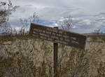
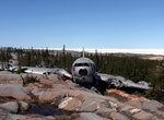
Hike to Miss Piggy C-46 crash Site, Churchill, Manitoba, Canada
Miss Piggy is a Curtiss C-46 freight plane owned by Lamb Air. On a 1979 flight, the plane had engine trouble during its approach to the runway and managed to land among the rocks without a fatality. Be careful the bears. It's amazing that the crew survived landing on these rocks! some pretty intricate artwork now adorns the plane. -
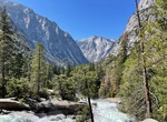
Hike Mist Falls Trail, Kings Canyon National Park, California
This sandy trail follows the glaciated South Fork Canyon through forest and chaparral, past an impressive show of rapids and cascades, to one of the largest waterfalls in Sequoia and Kings Canyon National Parks. The first part of this 8-mile round trip is relatively flat; during the last mile to the falls, the trail gains 600'. The average time for this trip is 4 to ...
Price: $121.33