Give us feedback!


 See all

Our philosophy is simple. We want to encourage you to dream. BIG! Then we help you plan your trip, get the most out of it while you're traveling and help you share your experience with friends.
Join Now It's FREE
Dream Packages
Duration: 10 hours
Price: $199.57
Price: $199.57
Duration: 4 days
Price: $772.57
Price: $772.57
Duration: 6 days
Price: $606.00
Price: $606.00
Duration: 12 hours
Price: $154.81
Price: $154.81
Related Categories
- Australian National Parks & Reserves
- Canadian National Parks
- Canyoneering
- Day Hikes
- Guided Hikes
- In the Mountains
- Mountaineering
- Mountains
- New Zealand Great Walks
- New Zealand National Parks
- Parks & Reserves
- Rock Climbing
- South African National Parks
- UK National Parks
- UNESCO Parks & Preserves
- US Historical Parks (NHP)
Dreams Still To Do
Checked-Off Dreams
Dreams Still To Do
Checked-Off Dreams
Advertisement
Explore Hikes & Treks
-
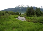
Hike Moraine Ecology Loop Trail, Mendenhall Glacier, Alaska
The Moraine Ecology Trail starts at the North side of the second parking lot at the Steep Creek trailhead. This trail explores the recently deglaciated landscape, meandering over an outwash plain and into a young forest. Offers glacier views, salmon viewing, birding, wildlife viewing, 25-100 years forest growth. -
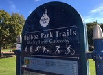
Hike Morley Field Trails, Balboa Park, San Diego, California
On the northeast side of the park is a gateway into three trails: The 2.3-mile trail follows a popular course used in high school cross-country competitions. Type: ½ grass, ½ dirt trail with some rocky areas. Difficulty level: Easy. Follow the #11 round red trail markers. View Google map. The 2.4-mile trail goes through not-often-seen natural areas of ... -
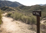
Hike Mormon Rocks Interpretive Trail, Cajon Junction, California
Beginning elevation is 3360 feet. This 1-mile loop trail was built by the Forest Service fire engine crew in 1975. It provides visitors with the chance to hike to a ridge to gain great views of the Mormon Rocks. These striking sandstone formations are riddled with small holes and caves; home of the owl, lizard, and pack rat. In the cliffs watch for White-throated Swi... -
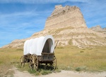
Hike along the Mormon Trail
The Mormon Trail or Mormon Pioneer Trail is the 1,300 mile (2,092 km) route that members of The Church of Jesus Christ of Latter-day Saints traveled from 1846 to 1868. Today the Mormon Trail is a part of the United States National Trails System, as the Mormon Pioneer National Historic Trail. The Mormon Trail extends from Nauvoo, Illinois, which was the principal settl... -
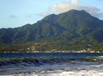
Summit Morne Diablotins, Dominica
Morne Diablotins is the highest mountain in Dominica, an island-nation in the Caribbean Lesser Antilles. It is the second highest mountain in the Lesser Antilles, after La Grande Soufrière in Guadeloupe. Morne Diablotins is located in the northern interior of the island, about 15 miles north of Dominica's capital Roseau and about 6 miles southeast of Portsmouth... -
Hike to Morong Falls, Kanangra-Boyd National Park, New South Wales, Australia
Morong Falls are a big set of falls located in Kanangra-Boyd National Park, New South Wales, Australia. -
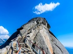
Summit Moro Rock, Sequoia National Park, California
To reach the top of this granite dome, follow a stairway that climbs 300 feet (0.09 km) to the summit. A spectacular view of the Great Western Divide and the western half of the park. The parking area is two miles (3.2 km) from the Generals Highway. In summer, free park shuttles lead to the parking area from Giant Forest Museum. Don't climb if ice or snow are present ... -
Summit Morro Dois Irmãos (Two Brothers), Rio de Janeiro, Brazil
TheDois Irmãos (Two Brothers Mountain) are the two iconic hills at the western end of the Ipanema/Leblon beaches in Rio de Janeiro. When looking at them from theIpanema Beach, it looks impossible to simply walk up this steep mountain. However there is a gentle slope on the back that is much easier than you’d think. If you’re only going to do one hik... -
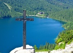
Hike or Horse-Drawn Cart to Morskie Oko, Tatra National Park, Poland
Morskie Oko is the largest and fourth deepest lake in the Tatra Mountains. It is located deep within the Tatra National Park, Poland, in the Rybi Potok Valley, at the base of the Mięguszowiecki Summits, in Lesser Poland Voivodeship. Morskie Oko has been recognized by the journalists of The Wall Street Journal as one of the five most beautiful lakes in the World. Morsk... -
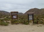
Hike to Morteros Palms, Anza-Borrego Desert State Park, California
It's a short hike to Mortero Palms in Anza-Borrego Desert State Park. The trail is also used by hikers going up to see the Carrizo Gorge Railway Trestle Bridge. -
Hike Morteros Trail (Blair Valley), Anza-Borrego Desert State Park, California
The Trail to Morteros is a short 1/2 mile trail in the Blair Valley in Anza-Borrego Desert State Park. The hike leads to native American grinding holes called bedrock mortars (morteros) by archeologists. The trailhead is located 3.5 miles off S-22. -
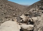
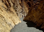
Hike Mosaic Canyon, Death Valley National Park
Mosaic Canyon is a canyon in the north western mountain face of Death Valley National Park valley which is named after a stream-derived breccia sediment with angular blocks of dolomite in a pebbly matrix. The entrance to Mosaic Canyon appears deceptively ordinary, but just a 1/4 mile (400m) walk up the canyon narrows dramatically to a deep slot cut into the face of Tu... -
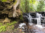
Hike to Mosquito Falls, Pictured Rocks National Lakeshore, Michigan
Mosquito Falls is located about 15 miles east of Munising off H-58, then about 5 miles north to the parking area at end of Chapel Road. Walking toward Mosquito Beach, a side trail leads almost a mile to the falls, which drops over an 8-foot high rock shelf on the Mosquito River. Watch for river otter and beaver in the stream. This is a lovely springtime trail through ... -
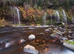
Hike to Mossbrae Falls, Dunsmuir, California
Mossbrae Falls is a waterfall flowing into the Sacramento River, in the Shasta Cascade area in Dunsmuir, California. The falls are located just south of the lower portion of Shasta Springs. Access to the falls via a mile-long hiking trail on the Union Pacific Railroad tracks is currently closed, as Union Pacific and the City of Dunsmuir figure out a safer route to the... -
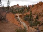
Hike Mossy Cave Trail, Bryce Canyon National Park, Utah
Mossy Cave is in the northern section of the park, located on Highway 12, approximately 4 miles east of the intersection of Highways 12 and 63. Look for a small parking area on the right-hand side immediately after crossing a little bridge. The Mossy Cave itself is at the end of a short trail. Here too you can see hoodoos and windows without having to hike a steep tra...


Price: $149.99