Give us feedback!


 See all

Our philosophy is simple. We want to encourage you to dream. BIG! Then we help you plan your trip, get the most out of it while you're traveling and help you share your experience with friends.
Join Now It's FREE
Dream Packages
Duration: 14 hours
Price: $341.00
Price: $341.00
Duration: 12 hours
Price: $154.81
Price: $154.81
Duration: 12 hours
Price: $160.26
Price: $160.26
Duration: 30 minutes
Price: $263.77
Price: $263.77
Related Categories
- Australian National Parks & Reserves
- Canadian National Parks
- Canyoneering
- Day Hikes
- Guided Hikes
- In the Mountains
- Mountaineering
- Mountains
- New Zealand Great Walks
- New Zealand National Parks
- Parks & Reserves
- Rock Climbing
- South African National Parks
- UK National Parks
- UNESCO Parks & Preserves
- US Historical Parks (NHP)
Dreams Still To Do
Checked-Off Dreams
Dreams Still To Do
Checked-Off Dreams
Advertisement
Explore Hikes & Treks
-
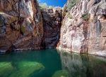
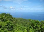
Hike to Motorcar Falls (Yirrmikmik Falls), Kakadu National Park, Northern Territory, Australia
Motorcar Falls can be reached via the Yirrmikmik Walk. The walk takes you through woodlands peppered with termite mounds and is approximately 7.5 km. Be on the lookout for antilopine wallaroos, red-tailed black cockatoos, finches (including Gouldian finches), hooded parrots and lorikeets. In the last 300 metres through the monsoon forest to the natural pool you may se... -
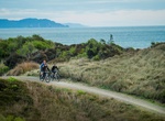
Hike or Mountain Bike Motu Trails, New Zealand
The Motu Trails are 3 trails in Eastland region in New Zealand between Opotiki in the Eastern Bay of Plenty and Matawai, which is 70km from Gisborne. Motu Trails offer a range of cycling itineraries depending on your age, fitness level and riding ability. Dunes Trail is a family fun ride that parallels the coastline of the Bay of Plenty for 11km.. Motu Road Trail st... -
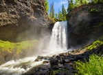
Hike Moul Falls, British Columbia
Moul Falls is a waterfall on Grouse Creek in Wells Gray Provincial Park, east-central British Columbia, Canada. It is one of the park's most popular short hiking trails. It is the only waterfall in the park that one can stand behind. Moul Falls is the third highest waterfall in the park, measured as a straight, unbroken drop. Grouse Creek rises from snowmelt, a lake a... -
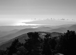
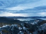
Summit Mount Achilles (Tasmania), Australia
Mount Achilles is a mountain in the Cradle Mountain-Lake St Clair National Park in Tasmania, Australia. It is the 20th highest mountain in Tasmania. Mount Achilles consists of two main summits, the highest is known as 'Achilles Heel', and the other is referred to as 'Perrins Bluff'. It is located in the more northern part of the park, and almost due east of Zeehan It ... -
Hike Mount Ainos National Park, Cephallonia, Greece
Mount Aenos or Ainos is the tallest mountain in the Ioanian island of Cephallonia, Greece, with an elevation of 1,628 metres (5,341 ft). Its bedrock is dominantly Cretaceous-era dolomite and limestone. Most of the mountain range is designated as a National Park area and is covered with Greek fir (Abies Cephalonica) and black pine (Pinus nigra). Pine forests are found ... -
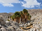
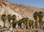
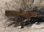
Hike Mountain Palm Springs - Southwest Grove Loop, Anza-Borrego Desert State Park, California
This trail routinely gets washes out during the summer storms and it is not marked well. You must pay close attention to where you’re going so you do not lose the trail. On this hike there should typically be some palm trees up the canyon within view. The trail starts right from the interpretive panel. Start walking toward the palms, and you will run into the t... -
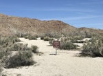
Hike to Mountain Palm Springs Trail (Bow Willow Palm Grove), Anza-Borrego Desert State Park, California
Bow Willow Palm Grove is a short 1,000 yards hike that starts at Bow Willow Campground in Anza-Borrego Desert State Park, California. This is not a well maintained trail. -
Hike Mountain Palm Springs Trail - North Fork (Torote Canyon & Palm Bowl), Anza-Borrego Desert State Park, California
Hike up past smoke trees into Indian Gorge to Torote Canyon to view native elephant trees, and then climb over a ridge to the very isolated Palm Bowl to view the most western palm oasis of Mountain Palm Springs. The trail goes by North Grove, Mary's Bowl Grove (Elephant and Palm Trees) andPalm Bowl, which is ringed by more than 100 palms. There is a primative campsit... -
Hike Mountain Palm Springs Trail - South Fork (Pygmy Grove and Southwest Grove), Anza-Borrego Desert State Park, California
Hike the Mountain Palm Springs Trail (South Fork) to Pygmy Grove and Southwest Grove. It's a moderate, 3 miles round trip (1.5 hours). From I-8 exit on S2 at Ocotillo. Go northwest on S2 for about 18 miles. There are two trailhead: Bow Willow Campsite: past the turnoff for Bow Willow Road. The trailhead is about 1.60 miles down the dirt road. Mountain Palm Springs ... -
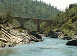
Hike to Mountain Quarries Railroad Bridge (No Hands Bridge), California
This short walk brings you up to and then across the Mountain Quarries RailRoad Bridge, which was the longest concrete arch railroad bridge in the world when it was built in 1912. Enjoy great views of the Middle Fork American River Canyon and marvel at what was a fantastic feat of construction for its time. The triple span bridge was built by the Mountain Quarries Com... -
Hike Mountains-to-Sea Trail, North Carolina & Tennessee
The Mountains-to-Sea Trail (MST) is a long-distance trail, for hiking and backpacking, that runs across North Carolina from the Great Smoky Mountains to the Outer Banks. The trail's western endpoint is at Clingman's Dome, where it connects to the Appalachian Trail in the Great Smoky Mountains National Park. Its eastern endpoint is in Jockey's Ridge State Park on the t... -
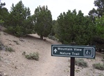
Hike Mountain View Nature Trail, Great Basin National Park, Nevada
This is a leisurely walk in the pinyon-juniper forest. The trail guide (available for loan at the visitor center desk) describes the geology and ecology of the area. The trail starts at the Rhodes Cabin next to the Lehman Caves Visitor Center. -
Summit Mount Alava, Tutuila, American Samoa
A hiking trail along the maintenance road leads to the 1,610' summit of Mt. Alava; the trailhead is located at Fagasa Pass, a short drive west of Pago Pago. The hike is 6 miles round trip; allow 3 hours for your hike up and 2 hours for your return to the pass. Source: WikiVoyage -
Summit Mount Anne & Eliza Plateau, Tasmania, Australia (UNESCO Site)
Mount Anne is a mountain in the Southwest National Park in Tasmania, Australia. It is within the UNESCO World Heritage listed Tasmanian Wilderness. Mount Anne is a common bushwalking destination for experienced walkers, the Mount Anne circuit is a 4 day walk that can include summiting Mount Anne Mount Anne is the nineteenth highest mountain in Tasmania, but the highes... -
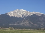
Summit Mount Antero, Sawatch Range, Colorado
Mount Antero is the highest summit of the southern Sawatch Range of the Rocky Mountains of North America. The prominent 14,276-foot (4351.4 m) fourteener is located in San Isabel National Forest, 12.2 miles (19.6 km) southwest by south (bearing 208°) of the Town of Buena Vista in Chaffee County, Colorado, United States. The mountain is named in honor of Chief Ante...
Price: $779.00