Give us feedback!


 See all

Our philosophy is simple. We want to encourage you to dream. BIG! Then we help you plan your trip, get the most out of it while you're traveling and help you share your experience with friends.
Join Now It's FREE
Dream Packages
Duration: 6 hours 30 minutes
Price: $167.71
Price: $167.71
Duration: 12 hours
Price: $224.21
Price: $224.21
Duration: 12 hours
Price: $160.26
Price: $160.26
Duration: 4 days
Price: $1026.70
Price: $1026.70
Related Categories
- Australian National Parks & Reserves
- Canadian National Parks
- Canyoneering
- Day Hikes
- Guided Hikes
- In the Mountains
- Mountaineering
- Mountains
- New Zealand Great Walks
- New Zealand National Parks
- Parks & Reserves
- Rock Climbing
- South African National Parks
- UK National Parks
- UNESCO Parks & Preserves
- US Historical Parks (NHP)
Dreams Still To Do
Checked-Off Dreams
Dreams Still To Do
Checked-Off Dreams
Advertisement
Explore Hikes & Treks
-
Summit Mount Yale, Colorado
Mount Yale is a high and prominent mountain summit of the Collegiate Peaks in the Sawatch Range of the Rocky Mountains of North America. The 14,200-foot (4328.2 m) fourteener is located in the Collegiate Peaks Wilderness of San Isabel National Forest, 9.4 miles (15.2 km) west by north (bearing 276°) of the Town of Buena Vista in Chaffee County, Colorado, United St... -
Hike Mount Zwegabin, Hpa-An, Myanmar
Mount Zwekabin is mountain in Myanmar. It is in the region of Karen, in the southern part of the country, 400 km south of the capital Naypyidaw. The top of Zwekabin is 722 metres (2,369 ft) above sea level. The terrain around Zwekabin Taung is flat to the north-west, but to the south-east it is hilly. Calculated from the variance of all elevation data (DEM 3 ") from ... -
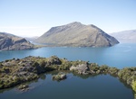
Explore Mou Waho, Lake Wānaka, New Zealand
Mou Waho is an island in Lake Wānaka, New Zealand. It is around the same size as the nearby Mou Tapu, these two islands being the largest in the lake. The island contains a small lake, called Arethusa Pool. Buff weka on the island are predators of much of the native wildlife including mountain stone wētā, cave wētā, and Southern Alps geckos. For this reason students o... -
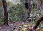
Hike Mt Aitken Track, Arthur's Pass National Park, New Zealand
The track passes an old pipeline that fed an electricity generator used during the rail tunnel construction, then climbs steeply to the bush line. Start on the Devils Punchbowl Walking Track at the northern end of Arthur's Pass village, just off SH73. The turnoff is signposted 15 min up the Devils Punchbowl Walking Track. -
Summit Mt Esja (Esjan), Iceland
The mountain Esja (914 m (2,999 ft)) often called Esjan ("the Esja") is situated in the south-west of Iceland, about 10 km to the north of Iceland's capital city Reykjavík. Esja is not a single mountain, but a volcanic mountain range, made from basalt and tuff-stone. Within easy reach of the capital, Esja is a very popular recreation area for hikers and climber... -
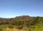
Hike Mt. Hollywood Trail, Los Angeles, California
Mount Hollywood Trail is a 5.3 mile heavily trafficked loop trail located near Los Angeles, California that features beautiful wild flowers and is rated as moderate. The trail offers a number of activity options and is accessible year-round. Dogs are also able to use this trail but must be kept on leash. -
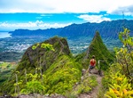
Hike Mt. Olomana Trail (Three Peaks), Oahu, Hawaii
The Mt. Olomana Trail, also known as the 'Three Peaks Hike', is a 2.9 miles (4.7 km) if you choose to hike all three peaks. It's a challenging hike on a mountain with 3 peaks, featuring ropes for climbing, exposure, and scenic views. The hike to the highest first peak is steep but not dangerous. There is a short climb required at the top with a rope in place to use, t... -
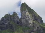
Hike to Mt. Otemanu Cave, Bora Bora, French Polynesia
Mt. Otemanu Cave offers sensational views overlooking some of the Bora Bora's best hotels and lagoon. The climb with a guide will take around 2–2.5 hours up & slightly less down. There are a few rope assisted sections – both up & down. -
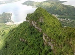
Hike to Mt. Pahia Summit, Bora Bora, French Polynesia
Mt Pahia is the third highest summit of Bora Bora and the second tallest climbeable. The trail starts near the center of Vaitape and it’s generally easy to follow. Don’t be fooled by the mountain’s relatively small size – 2,159 feet (658 meters). It can be a very tough hike with 45 degree steep on average. For safety’s sake, hire a gui... -
Summit Mt. Reynisfjall, Iceland
Hike up Mt. Reynisfjall near Vik, Iceland to see Reynisdrangar Pillars, Dyrholaey Island, Reynisfjara Black Sand Beach, and Solheimajokull Glacier. -
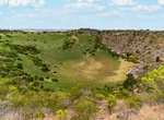
Hike to Mt Schank Lookout, Mount Schank, South Australia
Mount Schank is a 100 m (330 ft) high dormant volcano in the southeast corner of South Australia, near Mount Gambier. It was sighted by James Grant on 3 December 1800 and named after Admiral John Schank, designer of Grant's ship, HMSLady Nelson. Mount Schank is part of the Newer Volcanics Province, which is the youngest volcanic field in Australia. Mount Schank erupte... -
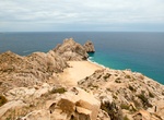
Hike Mt. Solmar, Cabo San Lucas, Baja California Sur, Mexico
Mt. Solmar is one of the most popular hikes in Cabo. It’s a fairly vigorous and steep hike that will take you up the mountain behind Lover’s Beach from the Pacific side or the Marina. The views are impressive and breathtaking. There are also two Satellite Tower Hikes that offer great views. One is on the mountainside behind the Costco along the Corridor. T... -
Hike Mud Hills Wash to Elephant Knees, Anza-Borrego Desert State Park, California
One of the most spectacular sights in the Split Mountain area of Anza-Borrego Desert State Park is a formation known as Elephant Knees. It's a mudhill ridge with thick fluted ridges that look like the knees of elephants. The flat top of Elephant Knees is a layer of marine sediments. It is visable from Fish Creek for for a closer look hike Mudhill Wash for a close... -
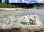
Explore Mud Volcano Group, Yellowstone National Park, Wyoming
The thermal features at Mud Volcano and Sulfur Cauldron are primarily mud pots and fumaroles because the area is situated on a perched water system with little water available. Fumaroles or "steam vents" occur when the ground water boils away faster than it can be recharged. Also, the vapors are rich in sulfuric acid that leaches the rock, breaking it down intoclay. B... -
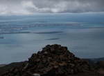
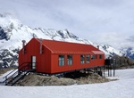
Hike Mueller Hut Route, Mount Cook National Park, New Zealand
At 1800 metres on the Sealy Range, Mueller Hut provides a 360-degree panorama encompassing glaciers, ice cliffs, vertical rock faces and New Zealand’s highest peaks. Start on the Kea Point Track either outside the Aoraki/ Mount Cook National Park Visitor Centre or at White Horse Hill car park, at the end of the Hooker Valley Road. Follow the Kea Point Track to ...


Price: $224.21