Give us feedback!


 See all

Our philosophy is simple. We want to encourage you to dream. BIG! Then we help you plan your trip, get the most out of it while you're traveling and help you share your experience with friends.
Join Now It's FREE
Dream Packages
Duration: 10 hours
Price: $121.33
Price: $121.33
Duration: 4 days
Price: $1026.70
Price: $1026.70
Duration: 4 hours
Price: $149.99
Price: $149.99
Duration: 12 hours
Price: $160.26
Price: $160.26
Related Categories
- Australian National Parks & Reserves
- Canadian National Parks
- Canyoneering
- Day Hikes
- Guided Hikes
- In the Mountains
- Mountaineering
- Mountains
- New Zealand Great Walks
- New Zealand National Parks
- Parks & Reserves
- Rock Climbing
- South African National Parks
- UK National Parks
- UNESCO Parks & Preserves
- US Historical Parks (NHP)
Dreams Still To Do
Checked-Off Dreams
Dreams Still To Do
Checked-Off Dreams
Advertisement
Explore Hikes & Treks
-
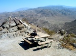
Hike Murray Hill Peak, Palm Springs, California
The Murray Hill Peak hike near Palm Springs is a great hike in the valley. It's a steep climb following a ridge of rolling hills with views of both sides of the valley. There is a nice set of picnic tables perched atop Murray Hill. This 8 mile in-and-out hike has a 2,100 foot elevation gain and takes about 6 hours. -
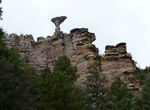
Hike Mushroom Rock Trail, Chiricahua National Monument, Arizona
The Mushroom Rock Trail connects the Ed Riggs Trail to the Big Balanced Rock Trail/Inspiration Point Trail. The trail follows along Hunt Canyon and climbs 530 feet over its 1.1-mile length. -
Hike to Music Pass & Sand Creek Lakes, Great Sand Dunes National Preserve, Colorado
A longer drive and/or a long hike is required for these destinations. However, the stunning alpine scenery is worth the effort. Check with a ranger for conditions before travel. Snow may block these trails from November into June. The trailhead for Music Pass from the east is accessed from Highway 69, 4.5 miles south of Westcliffe. Turn off Highway 69 to the west at t... -
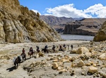
Mustang Valley, Nepal
Upper Mustang (formerly Kingdom of Lo) is an upper part (Northern area) of Mustang District, which is located in Nepal. TheUpper Mustangwas a restricted kingdom until 1992 which makes it one of the most preserved regions in the world, with a majority of the population still speaking traditional Tibetic languages. Tibetan culture has been preserved by the relative isol... -
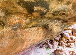
Visit Mutitjulu Cave, Uluru-Kata Tjuṯa National Park, Northern Territory, Australia
Mutitjulu Cave is nearby to Mutitjulu Waterhole along the Kuniya Walk. -
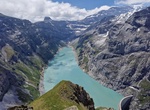
hike to Muttenchopf, Switzerland
Hike to viewpoint -
Hike Myer Valley to Happy's Stone Cabin, California
Myer Valley is located in the immense boulder piles when driving down Interstate 8 east of Jacumba. A man by the nickname of Happy built 2 houses in the area. A winter home is in a small drainage that joins Myers Creek near I-8. This rugged and picturesque high-desert area, administered by the federal Bureau of Land Management, gets relatively few visitors. -
Hike to Mymine (My Mine), Joshua Tree National Park, California
Mymine is located at the top of the north facing slope of the small knoll about 1/8th of a mile northeast of the Pinto Wye intersection. In 1967 several pieces of mining equipment and a shack were found he along with the main shaft. Nowdays the equipment is all gone and the shaft is mostly filled in. The old rails that led from the main shaft of Mymine to the tailing ... -
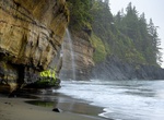
Hike to Mystic Beach, Juan de Fuca Provincial Park, Vancouver Island, British Columbia, Canada
Compact, gray-sand beach on the Juan De Fuca Marine Trail, with a cascade pouring over sheer cliffs. -
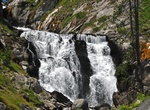
Hike to Mystic Falls (Biscuit Basin), Yellowstone National Park, Wyoming
Mystic Falls is a 70-foot (21 m) cascade type waterfall on the Little Firehole River, a tributary of the Firehole River. Originally namedLittle Firehole Fallsby members of the 1872 Hayden Geologic Survey, the name was changed toMystic Fallsby members of the Arnold Hague Geological Survey in 1885 for unknown reasons. The trail begins at the west end of the B... -
Hike Naches Peak Loop, Pacific Crest Trail, Washington State
The Naches Peak Loop is a trail route that goes around Naches Peak, containing a segment of the Pacific Crest Trail. -
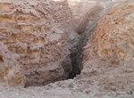
Hike Nahal Barak (Barak Gorge & White Canyon), Israel
Nahal Barak, also known as Barak gorge or Barak river, is a dry stream bed and canyon in the Arava desert in Israel's South District. When it is flooded, Nahal Barak forms part of the network of streams that drain the Negev desert. The stream itself is 18 km long, and flows into Nahal HaArava, which in turn flows into Nahal Paran. The stream cuts through limestone to ... -
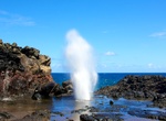
Hike to Nakalele Blowhole, Maui, Hawaii
Nakalele Point is a land mass at the northernmost point, on the western half on the island of Maui in the state of Hawaiʻi. In Hawaiian, Nakalele or Nā-kālele means "the leaning". The Point is known for it blowhole and has become notable for its dangerous conditions when waves crash in. The point and blowhole are located just east of Poelua Bay. Nakalele Point is famo... -
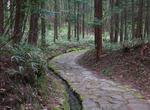
Hike Nakasendō Trail, Japan
The Nakasendō, also called the Kisokaidō, was one of the five routes of the Edo period, and one of the two that connected Edo (modern-day Tokyo) to Kyoto in Japan. There were 69 stations between Edo and Kyoto, crossing through Musashi, Kōzuke, Shinano, Mino and Ōmi provinces. In addition to Tokyo and Kyoto, the Nakasendō runs through the modern-day prefectures of Sait... -
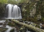
Hike to Naked Creek Falls, Shenandoah National Park, Virginia
Naked Creek Falls are located off-trail just a short hike from Naked Creek Overlook. Please note that there is no trail leading to these falls. This hike is for advanced hikers.
Price: $398.24