Give us feedback!


 See all

Our philosophy is simple. We want to encourage you to dream. BIG! Then we help you plan your trip, get the most out of it while you're traveling and help you share your experience with friends.
Join Now It's FREE
Dream Packages
Duration: 10 hours
Price: $224.21
Price: $224.21
Duration: 12 hours
Price: $224.21
Price: $224.21
Duration: 2 days
Price: $398.24
Price: $398.24
Duration: 12 hours
Price: $154.81
Price: $154.81
Related Categories
- Australian National Parks & Reserves
- Canadian National Parks
- Canyoneering
- Day Hikes
- Guided Hikes
- In the Mountains
- Mountaineering
- Mountains
- New Zealand Great Walks
- New Zealand National Parks
- Parks & Reserves
- Rock Climbing
- South African National Parks
- UK National Parks
- UNESCO Parks & Preserves
- US Historical Parks (NHP)
Dreams Still To Do
Checked-Off Dreams
Dreams Still To Do
Checked-Off Dreams
Advertisement
Explore Hikes & Treks
-
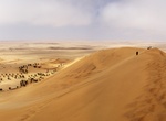
Explore Namib Desert Dune 7, Namibia
In the Namib Desert, just 10km outside the coastal town of Walvis Bay, one of the highest sand dunes in the world. The dune has been measured at over 1,256 feet (383 meters) and is named Dune 7 because it is the seventh dune one encounters after crossing the river Tsauchab. -
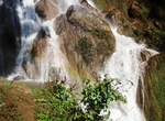
Cycle to Nam Tok Waterfall, Hsipaw, Myanmar
Nam Tok Water fall is close to Hsipaw town. It’s quite impressive and the way to get there is beautiful. Many people go by bicycle for a change from walking. -
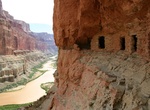
Hike to Nankoweap Creek Ancestral Puebloean Granaries from Colorado River, Grand Canyon National Park
Ancestral Puebloean granaries at Nankoweap Creek at Mile 52.4 on the Colorado River in Grand Canyon National Park in Arizona. Nankoweap Creek is a popular campsite. A steep trail up the talus slope leads to Ancestral Puebloean granaries with a spectacular view. -
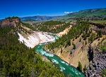
Hike Nankoweap Trail, Grand Canyon National Park, Arizona
The Nankoweap Trail is an unmaintained hiking trail on the North Rim of the Grand Canyon National Park. The trail descends 6,040 feet in 14 miles from the Saddle Mountain trailhead to Nankoweap Creek and on to the Colorado River. It is considered to be the hardest of the trails into the Canyon. Hikers have to carry and cache water as there is none in the 11 miles be... -
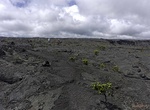
Hike Napau Crater Trail, Hawaii Volcanoes National Park, Hawaii
Note: The Nāpau Trail are subject to closure at any time. Everyone who plans to hike Nāulu Trail must self-register at the hiker's check-in station located at the trailhead. Nāpau Trail provides opportunities for hikers to experience a diversity of environments in Hawaiʻi Volcanoes National Park. The 14 mile round trip (7 + hours) hike is through varied terrain rangin... -
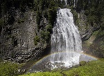
Hike Narada Falls Trail from Longmire, Mount Rainier National Park, Washington
The Narada Falls Trail (9 mi/14.5 km) follows the Nisqually River via the Wonderland Trail from Longmire, along this cool forest trail. En route to Narada Falls you will pass Carter and Madcap Falls. -
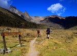
Hike Naro Moru Route, Mount Kenya, Mount Kenya National Park, Kenya
This route is taken by many of the trekkers who try to reach Point Lenana. It can be ascended in only 3 days and has bunkhouses at each camp so a tent is not necessary. The terrain is usually good, although one section is called the Vertical Bog. The track starts in Naro Moru town and heads past the Park Headquarters up the ridge between the Northern and Southern Naro... -
Hike Narrows Earth Trail, Borrego Springs, California
The Narrows Earth Trailhead is just off Route 78 next to “Powder Dump Wash”. The concrete and boulder near trailhead was built by the road crews back in the 1930’s. The crews named this area “Powder Dump Wash”. It was part of a storage house where they kept explosives. Along the trail you may have seen darker colored rocks. The... -
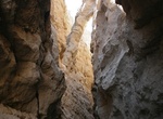
Hike Narrows in Blue John Canyon, Utah
The narrows of Blue John Canyon are some of the best anywhere in the Southwest. Blue John Canyon is a slot canyon in eastern Wayne County, Utah, southwest of the Horseshoe Canyon Unit of Canyonlands National Park and 42 miles south of Green River. It is a tributary of Horseshoe Canyon, running northeastwards from the Robbers Roost Flats. The canyon is deep with branc... -
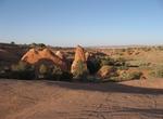
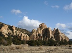
Hike Narrows Rim Trail, El Malpais National Conservation Area, New Mexico
Within the El Malpais National Conservation Area lies the Narrows. It is named for the 3-mile narrow corridor that developed when lava flowed close to the base of a 500-foot sandstone mesa. Most of the lava observed is from McCarty’s crater, and at approximately 1500 years old, it is the youngest flow in the area. The trailhead and parking area for the Narrows ... -
Hike Natchez Trace Trail, Tennessee, Alabama & Mississippi
The Natchez Trace Trail is a designated National Scenic Trail in the United States whose route generally follows sections of the 444-mile (715 km) Natchez Trace Parkway through the states of Tennessee, Alabama, and Mississippi. Unlike other national scenic trails, however, the trail is not envisioned as a long, continuous footpath, as is the case with other national s... -
Hike National Blue Trail, Hungary
The National Blue Trail is a national trail in Hungary incorporated into the European Long Distance Walking Route E4. The route starts atop the Irottkő Mountain (884 m) on the Austrian-Hungarian border then cuts across Hungary eventually ending 1,128 km later at the village of Hollóháza by the Hungarian-Slovakian border. (Interactive map). The name of th... -
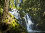
Hike to National Creek Falls, Oregon
An excellent day hike for the whole family! This short trail (0.4 mile) descends through a shaded, mixed conifer forest, ending at the base of the ever-flowing falls. -
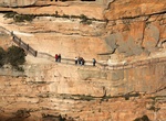
Hike National Pass, Blue Mountains, New South Wales
The National Pass is a 5.4km walk trail down to Wentworth Falls in the Blue Mountains, New South Wales. It takes around 3 hours to complete. The National Pass hiking track was built with picks, shovels, crowbars and dynamite between 1906 and 1907. It involved cutting a zig-zag staircase into a cliff face and became a very popular walking trail. Many say the National P... -
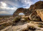
Hike to Natural Arch, Basin and Range National Monument, Nevada
Natural Arch is hole through a fin of volcanic rock in Basin and Range National Monument in Nevada. It is about 10 feet high and 15 feet wide. The arch has a commanding views over the surrounding terrain, which makes for great photos as the sun angle changes through the day.
Price: $149.99