Give us feedback!


 See all

Our philosophy is simple. We want to encourage you to dream. BIG! Then we help you plan your trip, get the most out of it while you're traveling and help you share your experience with friends.
Join Now It's FREE
Dream Packages
Duration: 12 hours
Price: $160.26
Price: $160.26
Duration: 2 days
Price: $469.00
Price: $469.00
Duration: 14 hours
Price: $341.00
Price: $341.00
Duration: 13 hours 30 minutes
Price: $572.77
Price: $572.77
Related Categories
- Australian National Parks & Reserves
- Canadian National Parks
- Canyoneering
- Day Hikes
- Guided Hikes
- In the Mountains
- Mountaineering
- Mountains
- New Zealand Great Walks
- New Zealand National Parks
- Parks & Reserves
- Rock Climbing
- South African National Parks
- UK National Parks
- UNESCO Parks & Preserves
- US Historical Parks (NHP)
Dreams Still To Do
Checked-Off Dreams
Dreams Still To Do
Checked-Off Dreams
Advertisement
Explore Hikes & Treks
-
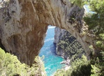
Hike to Natural Arch (Capri), Italy
The Natural Arch on the Italian island of Capri is all that remains of what was once a deep and incredibly high grotto. Thought to date all the way back to the Paleolithic era, today the limestone arch stands about 12 meters wide and 18 meters tall. Avid photographers will find that the arch can provide an ideal picture frame for capturing seascapes in the distance. L... -
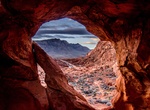
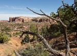
Hike to Natural Arch Trail (Valley of Fire), Valley of Fire State Park, Nevada
For an off-the-beaten-path experience, hike the Natural Arch Trail. This trail takes you through beautiful sandstone formations in an area that most people don’t know about. The trail is rather sandy, which makes it a little more difficult, but the lack of elevation gain makes up for it. Distance: 4.2 miles out and back How to Get There: Coming from the east ent... -
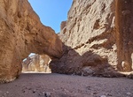
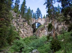
Hike Natural Bridge Trail, Death Valley National Park, California
Natural Bridge Canyon is found on the east side of the park and is one of the few canyons with an official trailhead. Located four miles (6 km) south of the Artist's Drive scenic loop, the canyon contains a natural stone bridge, accessible after a fifteen-minute walk from the parking area. This is an excellent short hike for families, geology lovers, and those who sim... -
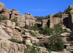
Hike Natural Bridge Trail, Chiricahua National Monument, Arizona
The least used trail in the monument climbs through oak and juniper woodlands to a ridge then drops into the Apache pine forest of Picket Park. It ends at an overlook for the small water-carved bridge located across the canyon. Return the same way. There is a small parking area along the Bonita Canyon Scenic Drive, 0.5 mile/ 0.8 km beyond the campground. -
Hike Natural Bridge Trail, Yellowstone National Park, Wyoming
The natural bridge is a 51 foot (18 m) cliff of rhyolite rock cut through by Bridge Creek. The hiking trail meanders through the forest for .7 of a mile (1.2 km). It then joins a service road and continues to the right (west) for .4 of a mile (0.6 km) to the Natural Bridge. The short but steep switchback trail to the top of the bridge starts in front of the interpreti... -
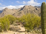
Hike or Ride Nature Trail, Catalina State Park, Arizona
Nature Trail is an easy 1 mile loop begins at the Trailhead parking lot, climbs a hill, then meanders through low foothills with typical desert scrub vegetation. Trailside signs feature local plants and animals, in addition to climate and geology information. Plan on 45 minutes of walking time. -
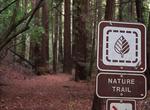
Hike Nature Trail, Cedar Breaks National Monument, Utah
This trail is an unpaved connects the the Point Supreme Campground with the Sunset Trail near Point Supreme.This path is great for viewing birds and park wildlife, and to get away from crowds. -
Hike Nature Trail at Pfeiffer Big Sur State Park, Big Sur, California
Take a short walk along this nature trail to discover some of the native plants and wildlife that surrounds you. The terrain changes dramatically along the trail from bay laurel trees to oaks, to redwoods, and you will learn how each of these plants plays an important roll within the local ecosystem. -
Hike Nature Trail (Mount Rushmore), South Dakota
The Nature Trail at Mount Rushmore is a short trail connects to the Borglum View Terrace to the parking area and features a glimpse at some of the natural resources found in the park. It is open year-round, weather permitting. -
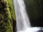
Hike to Nauthúsagil Waterfall, Iceland
Nauthúsagil Waterfall is located in the narrow Nauthúsagil Ravine in the southern Iceland. -
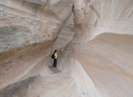
Hike to Nautilus Rock, Grand Staircase-Escalante National Monument, Utah
The Nautilus (Nautilus Rock) is the name of a beautiful formation of wind and water-eroded Page sandstone in Grand Staircase-Escalante National Monument, Utah. It's located at the edge of a small tributary ravine near the Paria River, 9 miles northeast of the equally photogenic Wave. The Nautilus is a formation in rock not far from the White House campground. This is... -
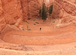
Hike Navajo Loop Trail, Bryce Canyon National Park, Utah
The Navajo Trail (1.3 mi/2.2 km round trip) is a loop trail that begins at Sunset Point and goes down into Bryce Amphitheater through a "slot" canyon where large Douglas-fir trees are stretching to reach sunlight high above. This is one of the more popular trails and can be combined with the Queens Garden Trail which will create a longer, but more varied, loop. ... -
Hike Neck Spring Trail, Canyonlands National Park, Utah
Neck Spring Trail is a 5.3 mile loop trail with the trailhead at Shafer Canyon Overlook in Canyonlands National Park, Utah. -
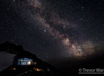
Hike to Neil Colgan Hut, Kootenay National Park
The Neil Colgan Hut (2,957 metres or 9,701 feet) is an alpine hut located on the Fay Glacier in Kootenay National Park in British Columbia, Canada. It is situated in a col between Mount Little and Mount Bowlen, which is one of the peaks overlooking The Valley of the Ten Peaks. The hut is maintained by the Alpine Club of Canada and is the highest permanent structu... -
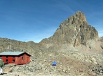
Summit Nelion, Mount Kenya, Mount Kenya National Park, Kenya
The summit of Nelion (5188m) is the second highest of Mount Kenya. Approximately 200 people summit Nelion each year. The Normal Route is the most climbed route up Nelion, and thence across to Batian. It was first climbed by Eric Shipton and Percy Wyn-Harris on 6 January 1929. It is possible to traverse between the Batian and Nelion peaks, via the Gates of Mist, but ...
Price: $121.33