Give us feedback!


 See all

Our philosophy is simple. We want to encourage you to dream. BIG! Then we help you plan your trip, get the most out of it while you're traveling and help you share your experience with friends.
Join Now It's FREE
Dream Packages
Duration: 13 hours 30 minutes
Price: $572.77
Price: $572.77
Duration: 12 hours
Price: $154.81
Price: $154.81
Duration: 2 days
Price: $398.24
Price: $398.24
Duration: 4 hours
Price: $129.99
Price: $129.99
Related Categories
- Australian National Parks & Reserves
- Canadian National Parks
- Canyoneering
- Day Hikes
- Guided Hikes
- In the Mountains
- Mountaineering
- Mountains
- New Zealand Great Walks
- New Zealand National Parks
- Parks & Reserves
- Rock Climbing
- South African National Parks
- UK National Parks
- UNESCO Parks & Preserves
- US Historical Parks (NHP)
Dreams Still To Do
Checked-Off Dreams
Dreams Still To Do
Checked-Off Dreams
Advertisement
Explore Hikes & Treks
-
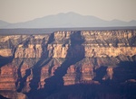
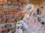
Hike North Bass Trail, Grand Canyon National Park, Arizona
The North Bass Trail is a very strenuous 13.5 miles (22.7 km) hiking trail located on the North Rim of the Grand Canyon, in Grand Canyon National Park, located in the U.S. state of Arizona. It has a 5728 ft elevation change. The trail is accessible by use of U.S. Forest Service roads along the north rim of Grand Canyon. The trailhead is located in the remote back... -
Explore North Bluff Preserve, Del Mar, California
North Bluff Preserve is located just north of Del MarDog Beach and is on the border of Del Mar and Solona Beach. -
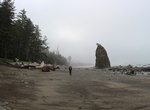
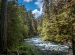
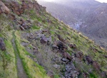
Hike North Coast Route Trail (Rialto to Shi Shi Beach), Olympic National Park, Washington
The North Coast Route Trail covers 20 mile along the pacific coast of Olympic National Park from Ozette Trailhead to Rialto Beach (allow 3-4 days) and 15 miles from Shi Shi Beach Trailhead to Ozette Trailhead (allow 2 days). It's part of the Pacific Northwest Trail. The Ozette River should be forded at Low tide. It may be impassable in winter and during periods o... -
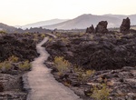
Hike North Crater Flow Loop Trail, Craters of the Moon National Monument, Idaho
The North Crater Flow Loop Trail goes onto the North Crater Flow, a pahoehoe flow that spilled from the North Crater vent about 2000 years ago. Signs along this short trail provide an excellent introduction to the variety of features that you will see all along the loop. No off-trail travel is permitted in this area in order to protect fragile lava formations. The No... -
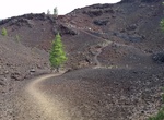
Hike North Crater Trail, Craters of the Moon National Monument, Idaho
The North Crater Trail (3.5 miles/5.6 km) is especially interesting for its variety. The trail traverses North Crater and drops into the crater mouth, the vent for the North Crater flow. Notice that the northwest flank of North Crater is missing. An eruption tore the wall apart, and a series of aa flows rafted the fragments away. The trail continues to the rim of Big ... -
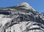
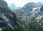
Hike to North Dome, Yosemite National Park
North Dome is a granite dome in Yosemite National Park, California. The hike takes you through some great meadows, past a rare granite arch called Indian Arch, and onto the granite of North Dome. North Dome is on the North Rim of Yosemite Valley right across from Half Dome, making the North Dome view spectacular. It is the southernmost summit of Indian Ridge, 0.6 mile... -
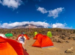
Trek Northern Circuit Route, Mount Kilimanjaro, Tanzania
The Northern Circuit is the newest route on Kilimanjaro and takes 8–9 days. The trek follows the Lemosho trail in the beginning, approaching Kilimanjaro from the west. However, instead of following the southern traverse like all the other west approaching routes, the Northern Circuit traverses the mountain around the quiet, rarely visited northern slopes. It beg... -
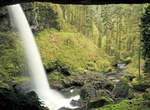
Hike to North Falls, Silver Falls State Park, Oregon
North Falls is a 136 feet (41 m) waterfall located in the Silver Falls State Park at the east end of the city of Salem, in Marion County, in the U.S. state of Oregon. It is located in a privileged area on the west foothills where Mount Hood National Forest meets with the Middle Santiam Wilderness. Several prominent waterfalls are located in the Park along Trail of Ten... -
Hike North Fork Quinault River Trail, Olympic National Park, Washington
The North Fork Quinault River Trail is 16 miles to Low Divide. River ford required at Wild Rose Creek and 16-Mile. These crossings can be hazardous during high water. The Elip Creek footlog often washes out in winter. Check current conditions. Horses are able to use this trail. The North Fork Road may be closedduring winter. Visit the Road Conditions page for more ... -
Hike North Fork Skokomish River Trail, Olympic National Park, Washington
North Fork Skokomish River Trail is a 23.7 mile out and back trail located in Olympic National Park that features a river and is rated as difficult. The trail rises about 900 feet over the first 4 miles to the junction of Flapjacks trail. Entrance to trail starts at Staircase Campground. -
Hike North Fork Trail, Advance, California
North Fork Trail is a 9.5 mile lightly trafficked out and back trail located near Advance, California that features a great forest setting and is good for all skill levels. The trail is primarily used for hiking, walking, nature trips, and birding and is accessible year-round. -
Summit North Fortuna Mountain, San Diego, California
North Fortuna via Rolling Hills is a 4.9 mile loop trail located in Mission Trails Regional Park. This hike is considered difficult. The trail is used for hiking, mountain biking & road biking and is accessible all year. Leased dogs are welcomed. This trail is one of the 5-Peak Challenge trails. Take a photo at the summit at each of the trails and show it to ... -
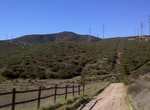
Summit North Franklin Mountain, El Paso, Texas
North Franklin Mountain (or North Franklin Peak) is a mountain in the Franklin Mountains of El Paso, Texas, located in the Southwestern United States. North Franklin, at 7,192 feet (2,192 m), is the highest point in El Paso, and the 27th-highest mountain in the state of Texas. Surrounded by a state park and with a maintained trail leading to its summit, the mountain i... -
Hike North Kaibab Trail, Grand Canyon National Park, Arizona
The North Kaibab Trail is a 14 mile (23 km) one-way hiking trail in the North Rim side of the Grand Canyon, in Grand Canyon National Park, located in the U.S. state of Arizona. It descends almost 6,000 ft. (1,800 m). Under no circumstances should anyone attempt to hike from the rim to the river and back in one day! Do not hike during the hottest part of the day. The N... -
Hike North Lykken Trail, Palm Springs, California
The North Lykken Trail is about 3 mile roundtrip to picnic tables overlooking downtown Palm Springs. After the picnic tables drop down to the trail that winds below the ridgeline behind the Las Palmas dam. Total distance is 5 miles with 1,000 foot elevation gain and takes about 4 hours. The picnic tables are also accessible from the Museum Trail that leads from the P...

Price: $149.99