Give us feedback!


 See all

Our philosophy is simple. We want to encourage you to dream. BIG! Then we help you plan your trip, get the most out of it while you're traveling and help you share your experience with friends.
Join Now It's FREE
Dream Packages
Duration: 4 days
Price: $663.61
Price: $663.61
Duration: 10 hours
Price: $224.21
Price: $224.21
Duration: 12 hours
Price: $154.81
Price: $154.81
Duration: 8 hours
Price: $214.32
Price: $214.32
Related Categories
- Australian National Parks & Reserves
- Canadian National Parks
- Canyoneering
- Day Hikes
- Guided Hikes
- In the Mountains
- Mountaineering
- Mountains
- New Zealand Great Walks
- New Zealand National Parks
- Parks & Reserves
- Rock Climbing
- South African National Parks
- UK National Parks
- UNESCO Parks & Preserves
- US Historical Parks (NHP)
Dreams Still To Do
Checked-Off Dreams
Dreams Still To Do
Checked-Off Dreams
Advertisement
Explore Hikes & Treks
-
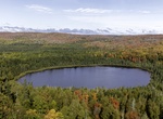
Hike Oberg Mountain Loop via Superior Trail, Minnesota
This 2.3-mile kid-friendly loop offers multiple overlooks of Lake Superior, Oberg Lake and Moose Mountain. -
Hike or Snowshoe Oberholtzer Trail, Voyageurs National Park, Minnesota
Travel from just outside the Rainy Lake Visitor Center to two overlooks to see the diversity of forest and wetland types in the park. This trail is wheelchair accessible for the first 1/4 mile. This trail is tracked for snowshoeing during the winter. -
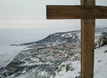
Hike Observation Hill (Ob Hill), McMurdo Station, Antarctica
Observation Hill is a steep 754-foot (230 m) hill adjacent to McMurdo Station in Antarctica and commonly called "Ob Hill." It is frequently climbed to get good viewing points across the continent. Regular clear skies give excellent visibility. Observation Hill is a lava dome and one of many volcanoes comprising the Hut Point Peninsula. After their deaths in early 1912... -
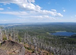
Hike to Observation Point/Peak, Yellowstone National Park, Wyoming
Walk counterclockwise around the Old Faithful boardwalk; turn right at the sign to Geyser Hill. Trailhead is on the right after the Firehole River bridge, approximately 0.3 miles (0.5 km) from the visitor center. Switchbacks lead up the hill 0.5 miles (0.8 km) to a commanding view of the Upper Geyser Basin. Return the same way or continue west to Solitary Geyser, whic... -
Hike to Observation Point via East Rim Trail, Zion National Park, Utah
Observation Point (from Weeping Rock) was closed on Jan. 18, 2019 due to rockfall. The Observation Point Trail is a trenuous hike to the highest point in Utah’s Zion National Park with a climb of 2,147 feet in a 4 miles. It is arguably one of the best views in this celebrated park—from its summit, one can see the Virgin River carving its way through Zion... -
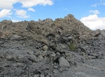
Summit Obsidian Dome, Mammoth Lakes, California
The Obsidian Dome north of Mammoth Lakes, California is a great place to vidit. Once at the to it appears like a different planet. The road is a single lane, grated dirt road with rocks, ruts, loose dirt. The road is accessed off the 395 just north of the dome. Head west and loop around the dome to the western side. There is a trail to the top from there. The lava do... -
Walk along Ocean Beach (San Francisco), California
Ocean Beach is a beach that runs along the west coast of San Francisco, California, United States, at the Pacific Ocean. It is adjacent to Golden Gate Park, the Richmond District and the Sunset District. The Great Highway runs alongside the beach, and Cliff House and the site of the former Sutro Baths sit at the northern end. The beach is a part of the Golden Gate Nat... -
Hike Oceanside Trail, Cabrillo National Monument, California
Oceanside Trail is a new (2024) trail to access the tidepool are on foot vai the Cabrillo National Monument Visitor Center. It's 0.5 miles each way. The trailhead starts at the top of the Whale Watch & Kelp Forest Overlook trail, south of the Old Point Loma Lighthouse. The trail is considered strenuous and will have stair steps, steep areas, uneven surfaces, and ... -
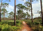
Hike Ocean to Lake Trail, Florida
Ocean to Lake Trail is a 63-mile greenway spur off the Florida Trail. It starts at Hobe Sound Beach and ends at Lake Okeechobee in Port Mayaca. The trail is under development as of 2012 and portions are open to the public in Jonathan Dickinson State Park, Corbett Wildlife Management Area, and DuPuis Reserve. The 2012 Ocean To Lake Greenway Celebration included horseba... -
Hike, Mountain Bike or Ski Ochre River Trail, Riding Mountain National Park, Manitoba, Canada
Ochre River Trail is 24.9 km (one-way) and situated deep within Riding Mountain National Park. Beginning just off Highway #10 and then winding its way through thick forest down to a parking lot on the north-eastern boundary of the park. There isn't another experience in Riding Mountain National Park that equals a trip on Ochre River Trail. Highlights along this trail... -
Hike or Ride Oconaluftee River Trail, Great Smoky Mountains, North Carolina
The Oconaluftee River Trail is one of two walking paths on which visitors can walk dogs and bicycle. Pets and bicycles are prohibited on all other park trails. The trail travels 1.5 miles one-way from the Oconaluftee Visitor Center to the outskirts of the city of Cherokee, NC. It is relatively flat, but does have a few small hills. The trail runs through the forest a... -
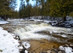
Hike Ocqueoc Falls Bicentennial Pathway, Township, Michigan
Hike along the Ocqueoc Falls Bicentennial Pathway to get the best view of Ocqueoc Falls, the largest waterfall in the Lower Peninsula. The pathway includes four loops from 3 miles to 6 miles in length and is suitable for hiking, biking and cross-country skiing. Not only will you be able to take in the beauty of the falls, but you will be able to be surrounded by the t... -
Hike Offa's Dyke Path, Wales & England
Offa's Dyke Path (Welsh:Llwybr Clawdd Offa) is a long-distance footpath following closely the Wales–England border. Opened in 1971, it is one of Britain's National Trails and draws walkers from throughout the world. Some of the 177-mile (285 km) route either follows, or keeps close company with, the remnants of Offa's Dyke, an earthwork, most of which was probab... -
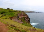
Hike Ohai Loop Trail, Maui, Hawaii
The short Ohai Loop Trail is located on Maui’s North Shore between mile marks 40 and 41 on Kahekili Highway (Hwy 30). The hike follows the coastline offering nice ocean views throughout. -
Hike or Bike Ohio & Erie Canal Towpath Trail, Cuyahoga Valley National Park, Ohio
The multi-purpose Ohio & Erie Canal Towpath trail was developed by the National Park Service and is the major trail through Cuyahoga Valley National Park. From it visitors can make connections to many of the natural and historic sites in the park and to other trails that intersect it along the way. The Towpath Trail follows the historic route of the Ohio & Er...


Price: $149.99