Give us feedback!


 See all

Our philosophy is simple. We want to encourage you to dream. BIG! Then we help you plan your trip, get the most out of it while you're traveling and help you share your experience with friends.
Join Now It's FREE
Dream Packages
Duration: 12 hours
Price: $160.26
Price: $160.26
Duration: 4 days
Price: $1026.70
Price: $1026.70
Duration: 13 hours 30 minutes
Price: $572.77
Price: $572.77
Duration: 4 hours
Price: $149.99
Price: $149.99
Related Categories
- Australian National Parks & Reserves
- Canadian National Parks
- Canyoneering
- Day Hikes
- Guided Hikes
- In the Mountains
- Mountaineering
- Mountains
- New Zealand Great Walks
- New Zealand National Parks
- Parks & Reserves
- Rock Climbing
- South African National Parks
- UK National Parks
- UNESCO Parks & Preserves
- US Historical Parks (NHP)
Dreams Still To Do
Checked-Off Dreams
Dreams Still To Do
Checked-Off Dreams
Advertisement
Explore Hikes & Treks
-
Hike Oregon Coast Trail
The Oregon Coast Trail is a long-distance hiking route along the Pacific coast of Oregon in the United States. It follows the coast of Oregon from the mouth of the Columbia River to the California border south of Brookings. The trail was created by Oregon Recreation Trails Advisory Council and managed by the Oregon Parks and Recreation Department as part of the state ... -
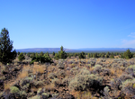
Hike Oregon Desert Trail (ODT), Oregon
The Oregon Desert Trail is a network of trails under development (as of June 2013) across the Oregon High Desert. The trail is between 750 and 850 miles (1,210 and 1,370 km) long, with termini located near Bend, Oregon, and near the Idaho border at Lake Owyhee State Park. The route is on existing trails and across tracts of public land—mostly Bureau of Land Mana... -
Hike Oregon Skyline Trail
The Oregon Skyline Trail is a long-distance trail in the Cascade Mountains of Oregon. The trail extends 428 miles (689 km) from Cascade Locks on the Columbia River south to Siskiyou Summit near the Oregon-California border. The century-old trail is a foot and equestrian path that passes through nine wilderness areas, Crater Lake National Park, and Cascade-Siskiyou Nat... -
Hike Ore Terminal Trail, Big Bend National Park, Texas
Ore Terminal Trail is a 8.5 mile out and back trail thst starts 0.85 miles down Marufo Vega Trail. -
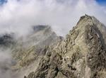
Hike Orla Perć (Eagle's Path), Tatra Mountains, Poland
Orla Perć (Eagle's Path) is a hiking trail in the Tatra Mountains in southern Poland. It is considered the most difficult and dangerous trails in the entire Tatras and is therefore a suitable destination only for experienced tourists and climbers. The path is marked with red signs. Since it was established, more than one hundred people have lost their lives on the rou... -
Hike to Orong Bukal, Sekotong Peninsula, Lombok, Indonesia
Orong Bukal is located on the southern coast of Sekotong and is one of the most underrated regions on Lombok. With crystal clear waters and jungle-covered limestone cliffs, this region is more reminiscent of Nusa Penida than the rest of Lombok. There is a 10-meter cliff jump at the end of a hot, tiring hike. At the trailhead there are local stores to buy some drin... -
Hike Orosi Volcano, Costa Rica
Orosi Volcano is an inactive volcano in Costa Rica, situated in the Cordillera de Guanacaste near the border with Nicaragua. The area around the volcano is a popular tourist destination, especially for more ecologically minded tourists due to its biodiversity, including the Guanacaste National Park. Volcán Orosí itself has a conical shape as viewed from ... -
Hike Orrido di Bellano, Lake Como, Italy
Lake Como gorge that is deep and narrow with waterfall. Accessible by a suspension bridge. Orrido ("gorge" or small canyon) was formed through erosion by the river Pioverna. The erosion started 15 million years ago. -
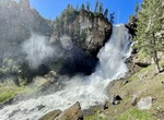
Hike to Osprey Falls, Yellowstone National Park, California
Osprey Falls is a waterfall on the Gardner River in northwestern Yellowstone National Park in the United States. Osprey Falls has a drop of approximately 150 feet (46 m). The falls are located within Sheepeater Canyon and are reachable via the Osprey Falls trail. Follow Old Bunsen Peak Road through grassland and burned forest 3 miles (4.9 km) to Osprey Falls Trail. De... -
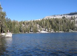
Hike to Ostrander Lake, Yosemite National Park
Ostrander Lake is located in Yosemite National Park, approximately 10 miles (16 km) south of Yosemite Valley and 10 miles (16 km) east of the Badger Pass Ski Area, at an elevation of 8,500 feet (2,600 m). The hike to Ostrander Lake is a long and strenuous 12.7 miles (20.4 km) roundtrip hike starting from the trailhead located just after Bridalveil Creek on the Glacier... -
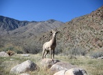
Hike Oswit Canyon, Palm Springs, California
This untouched oasis is home to an impressive variety of flora and fauna, including rare plant species, migratory birds, and desert wildlife. Home to endangered bighorn sheep, mountain lions, bobcats, and others! -
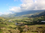
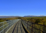
Hike or Ride Otago Central Rail Trail, New Zealand
The Otago Central Rail Trail is a 150-kilometre walking, cycling and horse riding track in the South Island of New Zealand. A pioneering project for New Zealand, the successful cycle trail joined the New Zealand Cycle Trail umbrella organisation in 2012, having been one of the inspirations for it. The trail runs in an arc between Middlemarch and Clyde, along the route... -
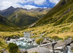
Hike Otira Valley Track, Arthur's Pass, New Zealand
Follow a deep alpine valley under the northern flank of Mount Rolleston/Kaimatau to the Otira River footbridge. -
Hike Otter Cave Hammock Trail, Everglades National Park, Florida
A rough limestone trail through a tropical hardwood forest with small footbridges over a small stream. Check at the Shark Valley Visitor Center for current conditions of trail, it sometimes can be flooded during the summer. Begins 0.5 miles (800 meters) behind the Shark Valley Visitor Center, off the Tram Road. -
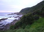
Hike Otter Trail, Garden Route, South Africa
The Otter Trail is a hiking trail along the Garden Route coast of South Africa and is named for the Cape Clawless Otter which occurs in this region. This trail is widely regarded as one of the finest in the world and stretches from Storms River Mouth in the east to Nature's Valley in the west, is 26 km long as the crow flies and 41 km as the hiker walks. Walking the t...


Price: $663.61