Give us feedback!


 See all

Our philosophy is simple. We want to encourage you to dream. BIG! Then we help you plan your trip, get the most out of it while you're traveling and help you share your experience with friends.
Join Now It's FREE
Dream Packages
Duration: 12 hours
Price: $154.81
Price: $154.81
Duration: 4 days
Price: $663.61
Price: $663.61
Duration: 10 hours
Price: $199.57
Price: $199.57
Duration: 4 days
Price: $1026.70
Price: $1026.70
Related Categories
- Australian National Parks & Reserves
- Canadian National Parks
- Canyoneering
- Day Hikes
- Guided Hikes
- In the Mountains
- Mountaineering
- Mountains
- New Zealand Great Walks
- New Zealand National Parks
- Parks & Reserves
- Rock Climbing
- South African National Parks
- UK National Parks
- UNESCO Parks & Preserves
- US Historical Parks (NHP)
Dreams Still To Do
Checked-Off Dreams
Dreams Still To Do
Checked-Off Dreams
Advertisement
Explore Hikes & Treks
-
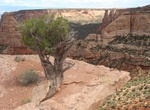
Hike Otto's Trail, Colorado National Monument, Colorado
Gently sloping trail that leads through pinyon-juniper woodlands to an overlook with views of Sentinel Spire, Pipe Organ, Praying Hands, and Independence Monument. Location: From Saddlehorn Visitor Center, turn left onto Rim Rock Drive and proceed 1.0 mile (1.6 km) to the trailhead onthe left. -
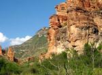
Hike Outer Mountain Loop, Big Bend National Park, Texas
Outer Mountain Loop trail in the Chisos, which begins in the Chisos Basin, climbs into the high mountains, descends into the desert along the Dodson Trail, and then returns to the Chisos Basin, completing a thirty mile loop. This 3 is considered a moderate backpacking trip and takes 3 days to complete. National Geographic names this hike one of the 20 Best Hikes in t... -
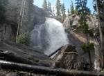
Hike to Ouzel Falls, Colorado
The full hike to Ouzel Falls is about 5.5 miles (9 km) round trip, with just under 1,000' elevation gain. -
Trek Overland Track, Tasmania, Australia
The Overland Track is one of Australia's most famous bush walks, situated in the Cradle Mountain-Lake St Clair National Park, Tasmania. More than 8000 walkers each year complete the track. Officially, the track runs for 65 km from Cradle Mountain to Lake St Clair. However, many choose to add the hike along Lake St Clair as a natural extension, bringing the length to 8... -
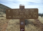
Hike Overlook Trail, Sonoita Creek State Natural Area, Arizona
The 1.5 mile Overlook Trail hike is moderate difficulty and is close to Patagonia Lake State Park. It is a great way to see 360 degrees of spectacular scenery. -
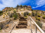
Hike Overlook Trail, Kershaw–Ryan State Park, Nevada
Experienced hikers may explore the park’s back country above the canyon via the 1.5-mile Overlook Trail. During the summer hikers should be alert for rattlesnakes, particularly along the trails and in the cool shady areas of the park. Also be alert for thunderstorms that may cause flash floods in the canyons. Plan hikes for the morning or evening hours. -
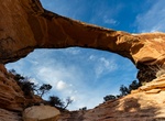
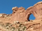
Hike to Owachomo Natural Bridge, Natural Bridges National Monument
Owachomo Bridge is the most accessible and most photographed natural bridge in the park. It's also likely the oldest natural bridge in the park. Owachomo Natural Bridge is located within Natural Bridges National Monument in Utah. The three bridges in the park are named Kachina, Owachomo, and Sipapu (the largest), which are all Hopi names. Owachomo is the smallest and... -
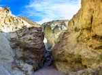
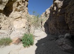
See Owl Canyon, Rainbow Basin, California
Owl Canyon is a beautiful and colorful canyon within Rainbow Basin Natural Area. It's mostly just a sandy drainage, but there was some Class 2 boulder-hopping. The badlands toward the head of the canyon were a little more difficult to navigate since trails lead in different directions. -
Hike Owl Creek to Nevills Arch, Cedar Mesa, Utah
These drainages both cut diagonally across the eastern edge of Cedar Mesa, coming together several miles before they enter Comb Wash. Both are deep canyons with abundant geolgical features. Maps needed for this area are either the Trails Illustrated Grand Gulch Plateau map, or the following USGS 7.5 quads: South Long Point, Bluff NW, and Snow Flat Spring Cave. Many o... -
Hike Oxbow Overlook Trail, Katmai National Park, Alaska
Oxbow Overlook Trail is a 0.5 mile out and back trail located near Brooks Camp in Katmai National Park. -
Hike Oyster Shell Wash, Anza-Borrego Desert State Park, California
Oyster Shell wash entrance is near the Wind Caves along Fish Creek in Anza-Borrego Desert State Park. The wash and it's fork are rugged steep canyons. To get to the trailhead a higher clearance car is essential and might need 4WD. -
Hike Along the Ozark Highlands Trail, Arkansas
The Ozark Highlands Trail roams 218 miles (351 km) through parts of seven counties in northwest Arkansas. It stretches from Lake Fort Smith State Park, across the Ozark National Forest, to the Buffalo National River. The trail passes through some of the most remote and scenic portions of the Ozark Mountains, like the Hurricane Creek Wilderness Area. It also crosses Wh... -
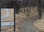
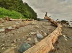
Hike Ozette Loop, Olympic National Park, Washington
The Ozette Loop combines the Sand Point Trail and theCape Alava Trail with a 2.9 mile beach walk to connect the two trails. Permits/Reservations: Reservations are required for camping in the Ozette area between May 1 and September 30. In the off-season, permits can be picked up at the WIC in Port Angeles. Group Size: Groups are limited to 12 people. Associated group... -
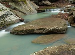
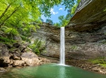
Hike to Ozone Falls, Tennessee
Ozone Falls is a waterfall located in Cumberland County, Tennessee in the Ozone Falls State Natural Area and Cumberland Trail State Park. Ozone Falls is situated along Fall Creek, which drains a short section of the Cumberland Plateau between the Crab Orchard Mountains to the west and Walden Ridge to the east. The creek flows down from its source high in the Crab Orch... -
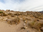
Hike Paac Kü̱vü̱hü̱’k, Joshua Tree National Park, California
The trailhead to Paac Kü̱vü̱hü̱’k is 5 miles (8 km) from the start of Geology Tour Road. 4-wheel drive is recommended; high clearance necessary beyond Paac Kü̱vü̱hü̱’k.
Price: $214.32