Give us feedback!


 See all

Our philosophy is simple. We want to encourage you to dream. BIG! Then we help you plan your trip, get the most out of it while you're traveling and help you share your experience with friends.
Join Now It's FREE
Dream Packages
Duration: 8 hours
Price: $214.32
Price: $214.32
Duration: 4 days
Price: $663.61
Price: $663.61
Duration: 6 to 10 hours
Price: $86.83
Price: $86.83
Duration: 12 hours 30 minutes
Price: $289.36
Price: $289.36
Related Categories
- Australian National Parks & Reserves
- Canadian National Parks
- Canyoneering
- Day Hikes
- Guided Hikes
- In the Mountains
- Mountaineering
- Mountains
- New Zealand Great Walks
- New Zealand National Parks
- Parks & Reserves
- Rock Climbing
- South African National Parks
- UK National Parks
- UNESCO Parks & Preserves
- US Historical Parks (NHP)
Dreams Still To Do
Checked-Off Dreams
Dreams Still To Do
Checked-Off Dreams
Advertisement
Explore Hikes & Treks
-
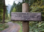
Hike Pacific Crest Trail (PCT)
The Pacific Crest Trail (commonly referred to as the PCT, and occasionally designated as the Pacific Crest National Scenic Trail) is a long-distance mountain hiking and equestrian trail closely aligned with the highest portion of the Sierra Nevada and Cascade Range, which lie 100 to 150 miles (160 to 240 km) east of the U.S. Pacific coast. The trail's southern terminu... -
Hike Pacific Crest Trail (PCT) in Sand to Snow National Monument, California
Sand to Snow National Monument features thirty miles of the world famous Pacific Crest National Scenic Trail, the area is a favorite for camping, hiking, hunting, horseback riding, photography, wildlife viewing, and even skiing. -
Hike Pacific Crest Trail (PCT) - Kitchen Creek Falls, California
This short and easy trail is a great start for beginners or those new to the PCT. With 3.6 miles and total elevation gain of 750, this trail is relatively flat with only moderate incline. Hiking south from the Kitchen Creek parking area, the trail takes travelers to the top of the falls for great views of the valley before descending down a social trail to the bottom.... -
Hike Pacific Crest Trail (PCT) - Kitchen Creek Road to Fred Canyon, California
This short and easy segment offers nice views of the surrounding cities with little incline or elevation change (550 gain if walking uphill from Kitchen Creek and downhill if walking from Fred Canyon). The shorter distance make it great for a half day hike and perfect for families or beginning hikers. For those looking for an introduction to the PCT, this trail is bes... -
Hike Pacific Crest Trail (PCT) - Lake Morena to Cottonwood Creek Bridge, California
Hike North on the PCT from the PCT parking area at Lake Morena for roughly 4 miles until reaching Cottonwood Creek bridge. This marks the halfway point. This 8 mile round trip offers moderate climbing with an elevation change of 1042 feet and steady rolling hills throughout. During the hike, travelers can expect minor sun cover and views of dense chaparral and Scrub O... -
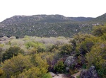
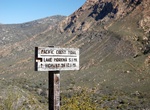
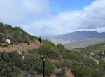
Hike Pacific Crest Trail (PCT) - Mexico Border to Lake Morena, Claifornia
The start of the PCT trail heading north from the Border Monument to Lake Morena is an extremely strenuous hike. This all-day endeavor offers minimal shade with weather that is often harsh (high heat). However, if looking for an adventure, this hike offers great exercise and viewpoints with inclines of 2814 feet and elevation loss of 2701, taking travelers weaving up ... -
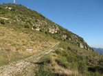
Hike Pacific Crest Trail (PCT) - Storm Canyon Lookout to Kwaaymii Point, California
This fantastic day long hike is roughly 11 miles and boasts some of the best views in San Diego. Though the actual trail up to Kwaaymii Point is only .5 miles, the trail itself is both historical (once being home to the Kwaaymii Indian Tribe) and well worth it, featuring live oaks, black oaks and Jeffrey Pines. Panoramic views of the Anza-Borrego Desert to the East, a... -
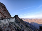
Hike or Ride Pacific Crest Trail (PCT) - Sunrise National Scenic Byway, Julian, California
The Sunrise National Scenic Byway is a small section of the Pacific Crest Trail ("PCT"). This section of trail was actually the pre-1975 Sunrise Highway. It was once an old roadbed that was chiseled into the cliff. This was once a very narrow and dangerous drive with a steep drop directly below you. -
Hike Pacific Crest Trail (PCT) through Donohue Pass, Yosemite National Park, California
Donohue Pass is a high mountain pass on the boundary between Yosemite National Park and the Ansel Adams Wilderness. Its elevation is 11,066 feet (3,373 m). It is situated between Mount Lyell and Donohue Peak. The John Muir Trail and the Pacific Crest Trail both transverse the pass. Following the John Muir Trail, the pass is 6.3 miles (10.1 km) from Thousand Island Lak... -
Hike Pacific Crest Trail To Red Dome, Whitewater Preserve, California
The 4.5 miles round-trip hike starts in Whitewater Preserve and goes along the Pacific Crest Trail To Red Dome. It's an elevaction gain of a little over 400 feet. Dogs are allowed on the trail. -
Hike Pacific Northwest Trail
The Pacific Northwest Trail (PNT) is a 1200-mile hiking trail running from the Continental Divide in Montana to the Pacific Ocean on Washington’s Olympic Coast. Along the way, the PNT crosses three national parks, seven national forests, two other national scenic trails, and against the grain of several mountain ranges, including the Continental Divide, Whitefis... -
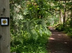
Hike Pagarine Route, France & Italy
Pagarine Route is a 10 stage 159km walking path from Nice on French Riviera up into the Italian hills to the city of Cuneo. was an important hub for the salt trade in the Middle Ages and the salt was brought ashore on Plage des Ponchettes in small wooden row boats before being taxed in nearby Cours Saleya, Nice’s centuries-old marketplace, and taken by mule on a... -
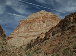
Hike Page Spring Trail, Grand Canyon National Park, Arizona
The Page Spring Trail in Grand Canyon National Park connects the Grandview Trail and Tonto Trail. Trail connects with Grandview Trail at Horseshoe Mesa. Page Spring (aka Miners Spring) is a permanent, year-round water source. -
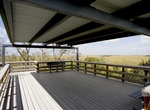
Hike to Pa-hay-okee Overlook, Everglades National Park, Florida
A raised observation platform on this boardwalk loop provides sweeping vistas of the "river of grass." The Pahayokee Trail is a 0.16-mile boardwalk, accessible and has an overlook platform. 13 miles (21 km) from the main park entrance/ Ernest Coe Visitor Center. -
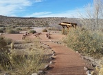
Hike Pahranagat Loop, Pahranagat National Wildlife Refuge, Nevada
This loop trail begins outside the main Entrance to the Visitor Center just over the bridge. Along the trail you’ll find interactive interpretative signs about the local flora and fauna. Throughout the trail you will see Cottonwood and Willow trees as well as other native flora which is some of the best songbird habitat on the refuge. Take a moment to stop and s...


Price: $398.24