Give us feedback!


 See all

Our philosophy is simple. We want to encourage you to dream. BIG! Then we help you plan your trip, get the most out of it while you're traveling and help you share your experience with friends.
Join Now It's FREE
Dream Packages
Duration: 2 days
Price: $398.24
Price: $398.24
Duration: 3 hours 15 minutes
Price: $371.99
Price: $371.99
Duration: 14 hours
Price: $341.00
Price: $341.00
Duration: 13 hours 30 minutes
Price: $572.77
Price: $572.77
Related Categories
- Australian National Parks & Reserves
- Canadian National Parks
- Canyoneering
- Day Hikes
- Guided Hikes
- In the Mountains
- Mountaineering
- Mountains
- New Zealand Great Walks
- New Zealand National Parks
- Parks & Reserves
- Rock Climbing
- South African National Parks
- UK National Parks
- UNESCO Parks & Preserves
- US Historical Parks (NHP)
Dreams Still To Do
Checked-Off Dreams
Dreams Still To Do
Checked-Off Dreams
Advertisement
Explore Hikes & Treks
-
Hike Pat Keyes Trail, Inyo Mountains, California
The Pat Keyes Trail is a difficult hiking trail starting from the Owens Valley floor into the Inyo Mountains Wilderness. From Highway 395 take Manzanar Reward Road East travel approximately 5 miles to base of mountains. Turn North on dirt road for .5 miles to trailhead. -
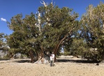
Hike Patriarch Grove, Ancient Bristlecone Pine Forest, California
Patriarch Grove is home of the world's largest Bristlecone Pine, the Patriarch Tree, and a self-guided nature trail. -
Hike Patrick's Causeway (Tochar Phádraigin), Ireland
Patrick's Causeway (Tochar Phádraigin) is an old pilgrim road to Croagh Patrick in the west of Ireland in County Mayo. The road is named after Saint Patrick, Ireland's patron saint, but pre-dates Christianity; it was probably built around 350AD, as the main route from Cruachan (seat of the Kings of Connacht) to Cruachan Aigle, the pagan name for Croagh Patrick.... -
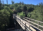
Hike Paul H. Douglas Trail (Miller Woods Trail), Indiana Dunes National Park, Indiana
Paul H. Douglas Trail, formerly the Miller Woods Trail, is located off Lake Street in Gary's Miller Beach community. The trail is fully accessible from a parking lot just north of the Douglas Center for Environmental Education. Miller Woods is a trail system in the far western part of Indiana Dunes National Park in the lakefront community of Miller Beach, Indiana. Mil... -
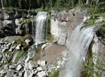
Hike to Paulina Creek Falls, Newberry National Volcanic Monument, Oregon
Paulina Creek Falls is a cascade and plunge waterfall from a streambed draining from Paulina Lake in Newberry National Volcanic Monument, south of Bend, Oregon. The waterfall is notable for its side-by-side drop of 80 feet (24 m) that surrounds a small island at the edge of the cliff. A paved foot out and back trail leads to Paulina Falls starting at the trailhead loc... -
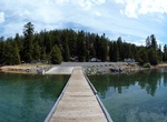
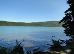
Explore Paulina Lake, Newberry National Volcanic Monument, Oregon
Paulina Lake is one of the twin crater lakes in Newberry Crater, central Oregon, United States (the other being East Lake). It is located 6,331 feet (1,930 m) above sea level in the Newberry National Volcanic Monument near La Pine. The lake's primary inflow is seepage from East Lake, snow melt, and hot springs, and its outflow is Paulina Creek, a tributary of the Litt... -
Hike to Paulina Lake Hot Springs, Oregon
Paulina Lake Hot Springs is located on the shore ofPaulina Lake near the Newbury Volcanic Monument in the Deschutes National Forest. -
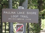
Hike Paulina Lakeshore Loop Trail, Newberry National Volcanic Monument, Oregon
Paulina Lakeshore Tral goes around Paulina Lake and connects to the Peter Skene Ogden Trail #3956, Crater Rim Trail #3957, and Little Crater Trail #3953. This trail is located within the Newberry National Volcanic Monument. -
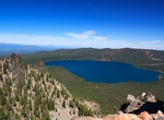
Summit Paulina Peak, Newberry National Volcanic Monument, Oregon
Paulina Peak is a summit in Deschutes County, Oregon, United States. Formed by the Newberry Volcano, it is part of Newberry National Volcanic Monument. At an elevation of 7,984 feet (2,434 m), it is the highest point on the volcano. The peak gives a panoramic view of the Newberry Caldera, the south and west flanks of the Newberry Volcano, the Cascades, the Fort Rock B... -
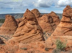
Hike to Paw Hole, South Coyote Buttes, Arizona
Paw Hole area of Coyote Buttes Special Management area is vast and remote. The trail route wanders around a lot of cool rock formations. There is no established trail. Head north-northeast to explore around the hoodoos and buttes. To access Coyote Buttes South take Paw Hole Road near the soutern part of House Rock Valley Road. From the north take House Rock Valley Roa... -
Hike PCT from Splinters Cabin, California
Splinters Cabin is an excellant starting point to visit Deep Creek in the Lake Arrowhead area. The world reknown Pacific Crest Trail (PCT) is a short walk from the parking lot, and the PCT traveling north from Spinter's follows Deep Creek for 14 miles. Deep Creek is a popular native trout fishery and swimming is another favorite visitor activity in the area. Splinters... -
Hike Peabody Creek Trail, Park Visitor Center, Port Angeles, Washington
Peabody Creek Trail is a 0.5 mile loop from the Visitor Center parking area. -
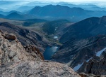
Hike to Peacock Pool, Colorado
Peacock Pool is a lake in Colorado and has an elevation of 11,309 feet. Peacock Pool is situated nearby to Chasm Meadow Patrol Cabin, and close to Chasm Lake. -
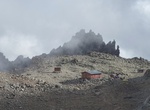
Hike Peak Circuit Path, Mount Kenya, Mount Kenya National Park, Kenya
Peak Circuit Path is a path around the Mount Kenya's main peaks, with a distance of about 10 kilometres (6 mi) and height gain and loss of over 2,000 metres (6,600 ft). It can be walked in one day, but more commonly takes two or three. It can also be used to join different ascent and descent routes. The route does not require technical climbing. -
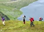
Hike Peak of Reinebringen, Reine, Norway
Hike the peak in lofoten islands Norway


Price: $214.32