Give us feedback!


 See all

Our philosophy is simple. We want to encourage you to dream. BIG! Then we help you plan your trip, get the most out of it while you're traveling and help you share your experience with friends.
Join Now It's FREE
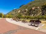
Dream Packages
Duration: 4 hours
Price: $129.99
Price: $129.99
Duration: 3 hours 15 minutes
Price: $371.99
Price: $371.99
Duration: 4 days
Price: $1026.70
Price: $1026.70
Duration: 10 hours
Price: $121.33
Price: $121.33
Related Categories
- Australian National Parks & Reserves
- Canadian National Parks
- Canyoneering
- Day Hikes
- Guided Hikes
- In the Mountains
- Mountaineering
- Mountains
- New Zealand Great Walks
- New Zealand National Parks
- Parks & Reserves
- Rock Climbing
- South African National Parks
- UK National Parks
- UNESCO Parks & Preserves
- US Historical Parks (NHP)
Dreams Still To Do
Checked-Off Dreams
Dreams Still To Do
Checked-Off Dreams
Advertisement
Explore Hikes & Treks
-
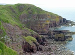
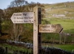
Hike Pembrokeshire Coast Path, Wales
The Pembrokeshire Coast Path is a National Trail in southwest Wales. It was established in 1970, and is 186 miles (300km) long, mostly at cliff-top level, with 35,000 feet (11,000 m) of ascent and descent. The northern end is at Poppit Sands, near St. Dogmaels, Ceredigion, the southern end is at Amroth, Pembrokeshire. Walkers on the path have access to the range of sa... -
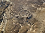
Hike to Peñasco Blanco & Supernova Pictograph, Chaco Culture National Historical Park, New Mexico
Peñasco Blanco ("White Bluff" in Spanish) is a Chacoan Anasazi great house and notable archaeological site located in Chaco Canyon, a canyon in San Juan County, New Mexico, United States.. It is an arc-shaped compound built atop the canyon's southern rim; it was constructed in five distinct stages between 900 AD and 1125 AD. A cliff painting (the "Supernova Pl... -
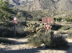
Hike Peña Springs Trail, Anza-Borrego Desert State Park, California
The Pena Spring Trail is an easy, 1/2 mile round trip hike to a water source through chaparral vegetation. The trail head is at the Culp Valley Primitive Camp off County S-22. Take the left fork once on the dirt road the the campesite to Pena Springs parking lot. -
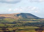
Hike Pendle Hill, Lancashire, England
Pendle Hill is located in the east of Lancashire, England, near the towns of Burnley, Nelson, Colne, Clitheroe and Padiham, an area known as Pendleside. Its summit is 557 metres (1,827 ft) above mean sea level. Pendle Hill is famous for its links to three events which took place in the 17th century: the Pendle witch trials (1612), Richard Towneley's barometer experime... -
Hike Pendley Homestead Trail, Slide Rock State Park, Arizona
Pendley Homestead Trail is a 0.25 mile trail with a difficulty rating of easy. This paved, level trail is suitable for all visitors and travels through a portion of the historic Pendley Homestead of Slide Rock State Park. Features along the trail include some of the original apple orchards, Pendley Homestead house, tourist cabins, apple packing barn, various farming i... -
Trek Pennine Way, England
The Pennine Way is a National Trail in England. The trail runs 429 km (267 mi) from Edale, in the northern Derbyshire Peak District, north through the Yorkshire Dales and the Northumberland National Park and ends at Kirk Yetholm, just inside the Scottish border. The path runs along the Pennine hills, sometimes described as the "backbone of England". Although not the U... -
Walk along Pennsylvania Avenue, Washington, D.C.
Pennsylvania Avenue is a street in Washington, D.C. that joins the White House and the United States Capitol. Called "America's Main Street", it is the location of official parades and processions, as well as protest marches. Moreover, Pennsylvania Avenue is an important commuter route and is part of the National Highway System. The avenue runs for a total of 5.8 mile... -
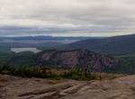
Hike Penobscot Mountain Trial, Acadia National Park, Maine
Penobscot Mountain Trail is a 3 mile out and back trail located west of Jordan Pond. Dogs are also able to use this trail but must be kept on leash. Penobscot Trail is not recommended for pets. -
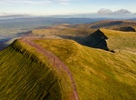
Explore Pen y Fan, Brecon Beacons National Park, Wales
Pen y Fan is the highest peak in south Wales, situated in the Brecon Beacons National Park. At 886 metres (2,907 ft) above sea-level, it is also the highest British peak south of Cadair Idris in Snowdonia. The twin summits of Pen y Fan and Corn Du at 873 m (2,864 ft) were formerly referred to as Cadair Arthur or 'Arthur's Seat'. The mountain and surrounding area are o... -
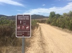
Hide or Ride Perimeter Trail North, Mission Trails Regional Park, California
Hike, mountain bike or ride horses along the Perimeter Trail North in Mission Trails Regional Park. The trailhead starts at East Fortuna Staging Area (Mast Blvd and Route 52). The trail goes West along the southern part of Route 52. -
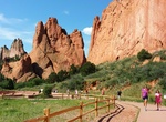
Hike Perkins Central Garden Trail, Garden of the Gods, Colorado
Perkins Central Garden Trail is an easy, 1 1/2 mile roundtrip path, with less than a 30 foot rise. This trail is in the heart of the Park at the base of the highest rock formations. -
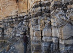
Hike Permian Reef Trail, Guadalupe Mountains National Park, Texas
Permian Reef Trail in Guadalupe Mountains National Park, Texasis a strenuous 8.4 miles round-trip with 2,000 feet of elevation gain. There are excellent views into McKittrick Canyon from the top of Wilderness Ridge. For serious geology buffs, this trail has stop markers that can be used with a comprehensive geology guide, available at the park's Headquarters Visitor ... -
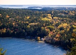
Hike Perpendicular Trail (Mansell Mountain), Acadia National Park, Maine
Perpendicular Trail on Mansell Mountain is a 2.2 miles (3.5 km) round trip hike up a lot of rocky stairs and iron rungs with views of Long Pond. Pets are not allowed on Perpendicular Trail. Starts/ends at: South end of Long Pond (near Southwest Harbor) -
Summit Peters Dome, Denali National Park, Alaska
Peters Dome is a 10,571-foot (3,222 m) mountain in the central Alaska Range, in Denali National Park, 7.6 mi (12 km) northwest of Denali. It is separated from Denali by a deep glacial valley, the Peters Basin, which is the source of Peters Glacier, about 3,000 feet (910 m) below Peters Dome's summit. It is described as a glacier-covered dome. -
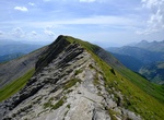
Summit Petit and Grand Croisse Baulet, France
Start this hike in the heart of mountain pastures, then in rhododendrons fields. Then onto Petit Croisse Baulet, which offers a glimpse of the panorama observable from the top of Grand Croisse Baulet. The steep final climb, which begins at the Col de l’Avenaz, is the only real difficulty of the hike. You can stop for lunch in one of our mountain restaurants: l...


Price: $160.26