Give us feedback!


 See all

Our philosophy is simple. We want to encourage you to dream. BIG! Then we help you plan your trip, get the most out of it while you're traveling and help you share your experience with friends.
Join Now It's FREE
Dream Packages
Duration: 4 days
Price: $772.57
Price: $772.57
Duration: 14 hours
Price: $341.00
Price: $341.00
Duration: 4 hours
Price: $149.99
Price: $149.99
Duration: 8 hours
Price: $214.32
Price: $214.32
Related Categories
- Australian National Parks & Reserves
- Canadian National Parks
- Canyoneering
- Day Hikes
- Guided Hikes
- In the Mountains
- Mountaineering
- Mountains
- New Zealand Great Walks
- New Zealand National Parks
- Parks & Reserves
- Rock Climbing
- South African National Parks
- UK National Parks
- UNESCO Parks & Preserves
- US Historical Parks (NHP)
Dreams Still To Do
Checked-Off Dreams
Dreams Still To Do
Checked-Off Dreams
Advertisement
Explore Hikes & Treks
-
Hike Piegan Pass Trail via Siyeh Bend Trail, Glacier National Park, Montana
Piegan Pass Trail is a 24.7 mile out and back trail located in Glacier National Park. The trailhead at Siyah Bend is along Going-to-the-Sun Road 2.2 miles east of Logan Pass. Hikers start off at the Siyeh Bend Trailhead and climb up to meet the Continental Divide Trail at about mile 1.1. Going right goes down to the Jackson Glacier Overlook. Turn left to head towards... -
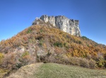
Hike to Pietra di Bismantova, Italy
The Pietra di Bismantova is a geological formation in the Reggiano Apennines, in thecomuneof Castelnovo ne' Monti, province of Reggio Emilia, central Italy, c. 45 km from Reggio Emilia. It has the shape of a narrow, quasi-cylindrical plateau (measuring 1 km x 240 m) whose steep walls emerge c. 300 m as an isolated spur from the nearby hills. The top has an elevat... -
Hike, Ski or Ride Pig Iron Trail, Oregon
This trail is a left-over section of the old Two Rivers trail from Clearwater River over Pig Iron Mountain to the North Umpqua River. A steep hike with challenging terrain, the trail takes hikers through unique and interesting geological areas. At the end of the trail, turn left to hike about 0.25-mile uphill to the Pig Iron Lookout, a secondary lookout which is usual... -
Walk to Pigmy Cabin Site, Holcomb Valley, California
Pigmy Cabin Site is stop #10 of the Gold Fever Trail near Big Bear Lake. It's about 300 yards hike to the remains of this cabin. The cabin originally only was 6 feet tall with a door of only 4 feet - hence the name. -
Hike Pihea Trail & Alaka'i Swamp Trail, Kauai, Hawaii
The Pihea Trail is located in Koke'e State Park on Kauai. The trail starts at the Pu'u o Kila overlook (at the end of Highway 550). This hike combines some of the best features of Kauai into an unforgettable hiking experience. It follows the Kalalau Valley passing through forest of Ohi'a trees, ferns, koa, and other native vegetation. About 2 miles from the trail... -
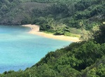
Hike to Pila'a Beach, Kauai
Pilaa Beach is a remote beach on the north shore of Kauai to relax without the crowds. It has gained fame as the beach fronting Mark Zuckerberg's property. The property behind Pilaa is privately owned and there is no direct right-of-way to the beach. The trail from the base of the hill to the west. It leads over the rocky shoreline to the west section of the beach. ... -
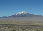
Explore Pilot Peak, Nevada
Pilot Peak (Shoshoni: Waahkai) is the highest mountain in the Pilot Range in extreme eastern Elko County, Nevada, United States. It is the most topographically prominent peak in Elko County and the fourth-most prominent peak in Nevada. The peak is on public land administered by the Bureau of Land Management and thus has no access restrictions. Pilot Peak was named in ... -
Summit Pilot Rock, Cascade-Siskiyou National Monument, Oregon
Pilot Rock is a prominent volcanic plug located in the western Cascade Range near the east end of the Siskiyou Mountains, just east of the Siskiyou Summit near Ashland, Oregon. Rising thousands of feet above the Shasta and Rogue valleys, it is a landmark distinguishable from over 40 miles (64 km) away. At 25.6 million years old, it is one of the oldest formations of t... -
Hike Pima Canyon Trails (Phoenix), Arizona
The Pima Canyon trails in the South Mountain Park offer many options. The Canyon area hikes of the park range from easy to moderate. For a challenge, hike up into South Mountain preserve. -
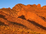
Hike Pima Canyon Trail (Tucson), Arizona
Pima Canyon is a major canyon located in the Santa Catalina Mountains, north of Catalina Foothills and Tucson, Arizona, USA. Pusch Ridge forms the northwestern cliffs of Pima Canyon, dramatically rising from Pima Creek on the canyon floor. Pima Canyon varies greatly in elevation, from 2,900 feet (880 m) above sea level at Pima Creek to 6,350 feet (1,940 m) at Pima Sad... -
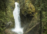
Hike to Pinard Falls, Oregon
Pinard Falls, named for Pinard Butte due east of the falls, is an impressive waterfall that forms when the East Fork of Layng Creek drops over 105-foot tall basalt cliffs. A dense, lush forest surrounds the area and shades the waterfall most of the day; however, during summer afternoons, sunlight cuts through the mist to reach the base of the waterfall. From the trai... -
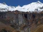
Hike Pindari Glacier, Kumaon Himalayas, India
The Pindari Glacier is a glacier found in the upper reaches of the Kumaon Himalayas, to the southeast of Nanda Devi, Nanda Kot. The glacier flows to the south for a short distance of about 3 km (1.9 mi),0.25 km in breadth and gives rise to the Pindari River which meets the Alakananda at Karnaprayag in the Garhwal district. The trail to reach the glacier crosses the vi... -
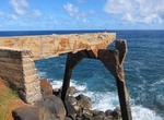
Hike or Ride to Pineapple Dump Bridge, Kauai, Hawaii
The remains of Pineapple Dump Bridge is located on the east side of Kauai north of Keālia Beach and south of Donkey/Paliku Beach. Walk along the Kauai Multiuse Path (Ke Ala Hele Makalae) to reach the bridge. From Kealia Beach the distance about a mile. The bridge was used by Pineapple farmers to dump their wastes into the ocean. -
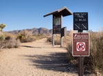
Hike Pine City and Pine City Canyon Trail, Joshua Tree National Park, California
Pine City and Pine City Canyon Trail is a 11 mile out and back trail located in Joshua Tree National Park. The highlight of this fairly flat trail is a dense stand of junipers and pinyon. The trail also goes to an old mining site. Backcountry camping is permitted in areas that are: 1 mile (1.6 km) from roads, 500 feet from trails and water sources, not day-use only a... -
Hike Pine Cliff Trail, Governor Dodge State Park, Wisconsin
This is a wooded 2.5-mile trail which begins at Enee Point picnic area and ends at Lakeview Trail on the southeast side of Cox Hollow Lake. An additional 2-mile self-guided loop interprets area history, wildlife, vegetation and ecology. On this trail, you will encounter several steps, steep grades and rocky surfaces. Hikers will enjoy the scenic views above Cox Hollow...


Price: $779.00