Give us feedback!


 See all

Our philosophy is simple. We want to encourage you to dream. BIG! Then we help you plan your trip, get the most out of it while you're traveling and help you share your experience with friends.
Join Now It's FREE
Dream Packages
Duration: 4 days
Price: $772.57
Price: $772.57
Duration: 12 hours
Price: $224.21
Price: $224.21
Duration: 10 hours
Price: $121.33
Price: $121.33
Duration: 2 days
Price: $398.24
Price: $398.24
Related Categories
- Australian National Parks & Reserves
- Canadian National Parks
- Canyoneering
- Day Hikes
- Guided Hikes
- In the Mountains
- Mountaineering
- Mountains
- New Zealand Great Walks
- New Zealand National Parks
- Parks & Reserves
- Rock Climbing
- South African National Parks
- UK National Parks
- UNESCO Parks & Preserves
- US Historical Parks (NHP)
Dreams Still To Do
Checked-Off Dreams
Dreams Still To Do
Checked-Off Dreams
Advertisement
Explore Hikes & Treks
-
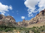
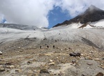
Hike Pine Creek Canyon Trail, Red Rock Canyon, Nevada
Pine Creek Canyon starts at the parking lot, then the trail runs downhill toward the canyon. The trail does get intersected at two points by Fire Ecology Trail and Dale's Trail, then forks near Old Wilson homestead foundation. The trail runs left, goes downhill, crosses a stream, then uphill toward an intersection with Arnight Trail. After crossing a wash, the main tr... -
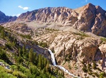
Hike Pine Creek Pass Trail, Bishop, California
Several trails start from the deep canyon cut by Pine Creek between Mount Tom and the Wheeler Crest. The Pine Creek Pass trail gives access to the Pine Lakes, along Pine Creek, and destinations beyond Pine Creek Pass. French Canyon and Humphreys Basin areas are popular destinations for visitors that go over Pine Creek Pass. From Bishop go north on Hwy 395 (approximat... -
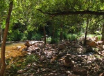
Hike Pine Creek Trail, Tonto Natural Bridge State Park, Arizona
Pine Creek Trail is about ½ mile long (400 feet developed - undeveloped in the creek bottom), leads to the Pine Creek natural area. Hiking shoes are recommended. Follow the arrows. Allow one hour. -
Hike Pine Grove Trail, Cuyahoga Valley National Park, Ohio
The 2.2 mile Pine Grove Trail is located near Ritchie Ledges at the Octagon Picnic Shelter. This kid-friendly route shows off the park’s diverse flora, with wildflowers at ground level and lush green hemlocks and oaks above. The nearby Forest Point Trail is a far easier half-mile and should take up to 30 minutes to trek. -
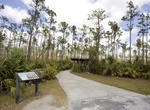
Hike Pineland Trail, Everglades National Park, Florida
This trail loops through a forest of pines, palmettos, and wildflowers. Seven miles (11km) from the main park entrance/ Ernest Coe Visitor Center. Wheelchair Accessible: Yes, though there are narrow and uneven places where roots have pushed the pavement up. -
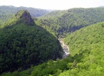
Hike Pine Mountain State Scenic Trail, Kentucky
Pine Mountain State Scenic Trail is a 120 mi (193 km) trail under development in the U.S. state of Kentucky. Once completed, the trail will wind along Pine Mountain Ridge from the Breaks Interstate Park to Cumberland Gap National Historical Park. The park itself will cover a 1,000 acres (4.0 km2) band along Pine Mountain. As of May 2014, the trail is completed from th... -
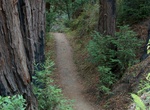
Hike Pine Ridge Trail, Los Padres National Forest, California
The Pine Ridge Trail is the most popular hiking trail in the Ventana Wilderness of the Los Padres National Forest, California. The 19.5 miles (31.4 km) trail traverses the Ventana Wilderness from the Big Sur Station near sea level to China Camp on Tassajara Road at 5,000 feet (1,500 m). Built in 1916 by the Post family of Big Sur, the Pine Ridge Trail offers hikers an... -
Mountain Bike or Hike Pinhoti National Recreation Trail, Alabama & Georgia
The Pinhoti Trail is a long-distance trail, 335 miles (540 km) long, located in the United States within the states Alabama and Georgia. The trail's southern terminus is on Flagg Mountain (the southern most Appalachian peak that rises over 1,000 feet (300 m) which is located near Weogufka, Alabama. The trail's northern terminus is where it joins the Benton MacKaye Tra... -
Visit Pinnacles Overlook, Crater Lake National Park, Oregon
On the Crater Lake's southeast slopes, the canyons of Wheeler and Sand Creeks became submerged in a searing pyroclastic flow during the massive blast 7,700 years ago. Gases from the superheated rock below were released to the surface via narrow vents, welding the pyroclastic deposits in their immediate vicinity. They may be viewed from overlooks at the end of the acc... -
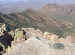
Hike Pinnacles Trail to Emory Peak, Big Bend National Park, Texas
Ascend the forested Pinnacles trail for 3.5 miles to the Emory Peak trail junction (on your right). Then take the 1-mile spur trail to the peak which has nice vistas along the way. The last quarter mile or so climbs steeply, and the last 25 feet require a scramble up an exposed rock face, but the 360° view from Emory Peak, the highest point in the park, is superb.... -
Trek Pin Parvati Pass, Himachal Pradesh, India
The Pin Parvati Pass is a mountain pass in Himachal Pradesh, India. It was first crossed in August 1884 by Sir Louis Dane in search of an alternate route to the Spiti valley. This pass connects the fertile and lush Parvati valley on the Kullu side with the Pin valley on the Spiti side. It is a popular trekking route today though still rarely visited. This trans-Himala... -
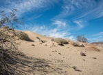
Hike Pinto Basin Sand Dunes Trail, Joshua Tree National Park, California
The Pinto "Sand Dunes" are piles of sand built up against a low-lying ridge of rocky hills. There is no maintained trail leading to the dunes, however the ridge is visible from Turkey Flats and a fairly direct N-NE path can be taken to them. The hike starts at the Turkey Flats Backcountry Board. According to local folklore, an enthusiastic farmer in the 1920s thought... -
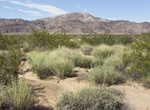
Hike Pinto Mountains thru Turkey Flats, Joshua Tree National Park, California
The Pinto Mountains are found in southern California, USA, at the north-central part of Joshua Tree National Park. The range reaches an elevation of 1,390 meters (4,560 ft) southeast of the city of Twentynine Palms. The range is made up of dark gneiss, and the creosote bush is the dominant plant in the area. The cross-country hiking route starts at Turkey Flats parkin... -
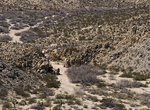
Hike to Pinto Wye Wash, Joshua Tree National Park, California
Off to the west of Pinto Wye is a wash will lead through a pretty neat little canyon, past several mines. -
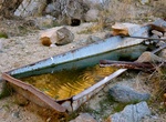
Hike to Pinyon Well, Joshua Tree National Park
Pinyon Well is located 0.7 miles up a canyon off Geology Tour Road in Joshua Tree National Park. Pinyon Well was a small, active community in the late 1890s and up through the 1910s. It was there because of a reliable source of water from three wells in the area, and the steam-powered, two-stamp mill that crushed ore for the nearby mines. A round-trip hike from the tr...


Price: $154.81