Give us feedback!


 See all

Our philosophy is simple. We want to encourage you to dream. BIG! Then we help you plan your trip, get the most out of it while you're traveling and help you share your experience with friends.
Join Now It's FREE
Dream Packages
Duration: 3 hours 15 minutes
Price: $371.99
Price: $371.99
Duration: 4 days
Price: $1026.70
Price: $1026.70
Duration: 6 hours 30 minutes
Price: $167.71
Price: $167.71
Duration: 4 days
Price: $663.61
Price: $663.61
Related Categories
- Australian National Parks & Reserves
- Canadian National Parks
- Canyoneering
- Day Hikes
- Guided Hikes
- In the Mountains
- Mountaineering
- Mountains
- New Zealand Great Walks
- New Zealand National Parks
- Parks & Reserves
- Rock Climbing
- South African National Parks
- UK National Parks
- UNESCO Parks & Preserves
- US Historical Parks (NHP)
Dreams Still To Do
Checked-Off Dreams
Dreams Still To Do
Checked-Off Dreams
Advertisement
Explore Hikes & Treks
-
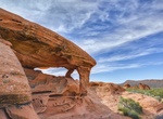
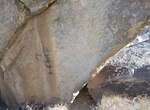
Hike to Piano Rock, Valley of Fire State Park, Nevada
If you squint, you just might see a piano in this striking sandstone formation. Piano Rock can be reached by way of a short 0.7-mile trail from the Firecave parking area in Valley of Fire State Park. Distance: 0.7 miles How to Get There: After passing the Arch Rock campground on the paved part of Campground Road in Valley of Fire State Park, reset your odometer as yo... -
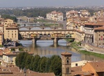
Stroll Piazza Signoria to San Miniato, Florence, Italy
This is a full experience taking you from the popular city center across the Arno river and up into the nearby hillside on Florence's "Left Bank. " Along the way explore less trodden piazzas, cafes, parks, small streets, churches, museums, shops as well as some of the more famous sites. It's about 2.5 miles (4.0 km) of a hike. Source: Everytrail -
Summit Picacho del Diablo, Baja California
Picacho del Diablo is the highest peak in Baja California, measuring 3,096 metres (10,157 ft). It is alternately called Cerro de la Encantada, "Hill of the Enchanted." The peak is located in the Sierra San Pedro Martir in the Mexican state of Baja California Norte. Experienced backpackers may want to summit Picacho del Diablo. The mountain is normally approached from ... -
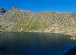
Summit Pic de Coma Pedrosa, Andorra
Coma Pedrosa is the highest mountain in the principality of Andorra. It is popular with mountain climbers, its ascent being technically straightforward, although strenuous. Several mountain lakes and tarns are found on the slopes, notably Estanys de Baiau, which lies on the western slopes, across the Spanish border. Pic de Coma Pedrosa 2,942 m 4h30, climb 1,370 m, med... -
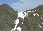
Hike Pic de Médécourbe, Andorra
Pic de Médécourbe is a mountain in Europe that sits on the western tripoint boundary of Andorra, France and Spain. It is 2,914 metres (9,560 ft) tall. It overlooks Étang de Soulcem, a large artificial lake used for hydroelectricity, and the Vicdessos valley. Pic de Médécourbe 2,914 m 4h30, climb 1,335 m, medium until the hut increasi... -
Hike Pic de Sanfonts, Andorra
Pic de Sanfonts is a mountain in the Pyrenees on the border of Spain and northwest Andorra. The nearest town is Arinsal, La Massana. It is a subpeak of, and 1.2 km southwest of, Coma Pedrosa (2942 m), the highest mountain in Andorra. Treks from Arinsal (1,500 m) - Pic de Sanfons (2,888 m, 4h45, climb 1,310 m, medium until the hut, difficult on the ridge). View on the ... -
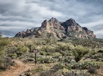
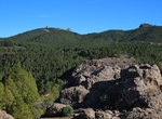
Hike to Picket Post Trail, Arizona
Picket Post trail is moderately challenging trail with a few parts where you have to scramble. One mile dirt road leading to trailhead. Restroom available. Recommend gloves, long pants, 1 hiking pole. -
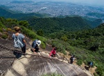
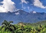
Summit Pico da Tijuca, Rio de Janeiro, Brazil
Pico da Tijuca is a mountain in the city of Rio de Janeiro, Brazil. The mountain is the most prominent peak of the Rio de Janeiro City urban zone. Pico da Tijuca is part of the 3,958.41 hectares (9,781.4 acres) Tijuca National Park protected area, established in 1961. There are stairs cut in the rock to reach the top of the peak. -
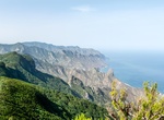
Hike to Pico de Chinobre, Tenerife Island, Canary Islands
Pico de Chinobre is a viewpoint with a short hike from TF-123. -
Summit Pico de las Nieves, Gran Canaria, Canary Islands
Pico de las Nieves is the second highest peak on the island of Gran Canaria, Canary Islands, Spain. Its height is 1,949 metres (6,394 ft) above sea level. It is of volcanic origin (stratovolcano). On its slopes, Canary Islands Pine was reintroduced in the 1950s. Traditionally, Pico de las Nieves has been considered the highest peak on the island of Gran Canaria; howev... -
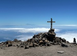
Summit Pico de las Nieves (La Palma Island), Canary Islands
The route to Pico de la Nieve is located in the famous Caldera de Taburiente and is one of the must- see attractions on the island of La Palma , Canary Islands. A peak of 2239 meters that is really one of the many points that make up the great crater of the island. For this reason, the views are exceptional and a great option to add to your visit to Roque de los Mucha... -
Summit Pico Turquino, Cuba
Pico Turquino is the highest point in Cuba. It is located in the southeast part of the island, in the Sierra Maestra mountain range in the municipality of Guamá, Santiago de Cuba Province. Guides are mandatory for this tough two- to three-day 17km trek through the steep forests of the Sierra Maestra. Revolutionary buffs should make a side trip to Fidel’s ... -
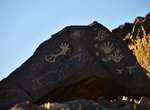
Hike Pictograph Trail, Anza-Borrego Desert State Park, California
The Pictograph Trail in Anza-Borrego Desert State Park is a 1.8-mile out and back hike to see large boulder that was used by Kumeyaay Indian painters who lived in the Anza-Borrego Desert over two thousand years ago. The pictographs are 1 mile from the trailhead. The trail ends 1.5 miles from the trailhead at a 100-ft. (30 m) dry fall in Smugglers Canyon. To get there ... -
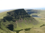
Hike Picws Du, Brecon Beacons National Park, Wales
Picws Du is the second highest peak of the Carmarthen Fans (or, in WelshBannau Sir Gaer) in the Carmarthenshire section of the Black Mountain in the west of the Brecon Beacons National Park in south Wales. The highest peak is Fan Foel immediately next along the ridge and it is a subsidiary summit of Fan Brycheiniog. Picws Du falls within Fforest Fawr Geopark and its p... -
Hike Piedras Marcadas Canyon Trail, Petroglyph National Monument, New Mexico
Located in the north-eastern tip of the monument, this moderate undeveloped trail system is 1.5 miles round-trip. Water is not available. No restroom facilities. No shade. See approximately 300-500 petroglyphs in 1.5 hours. Leashed pets allowed. A free trail guide is available at the visitor center. Located off Golf Course Road at Jill Patricia Street. Parking lot is...
Price: $199.57