Give us feedback!


 See all

Our philosophy is simple. We want to encourage you to dream. BIG! Then we help you plan your trip, get the most out of it while you're traveling and help you share your experience with friends.
Join Now It's FREE
Dream Packages
Duration: 12 hours 30 minutes
Price: $289.36
Price: $289.36
Duration: 10 hours
Price: $224.21
Price: $224.21
Duration: 10 hours
Price: $199.57
Price: $199.57
Duration: 10 hours
Price: $121.33
Price: $121.33
Related Categories
- Australian National Parks & Reserves
- Canadian National Parks
- Canyoneering
- Day Hikes
- Guided Hikes
- In the Mountains
- Mountaineering
- Mountains
- New Zealand Great Walks
- New Zealand National Parks
- Parks & Reserves
- Rock Climbing
- South African National Parks
- UK National Parks
- UNESCO Parks & Preserves
- US Historical Parks (NHP)
Dreams Still To Do
Checked-Off Dreams
Dreams Still To Do
Checked-Off Dreams
Advertisement
Explore Hikes & Treks
-
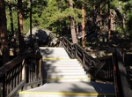
Hike Presidential Trail, Mount Rushmore National Memorial, South Dakota
Walk the Presidential Trail (0.6 miles long, 422 stairs, weather permitting) to get up close and personal with the mountain sculpture and perhaps glimpse some of the area wildlife. -
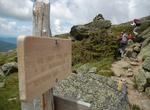
Hike Presidential Traverse, White Mountain National Forest, New Hampshire
A Presidential Traverse is a strenuous and sometimes dangerous trek over the Presidential Range of New Hampshire's White Mountains. Contained almost entirely in the 750,000-acre (3,000 km2) White Mountain National Forest, the Presidential Range is a string of summits in excess of 4,000 feet (1,200 m). To complete the traverse, one must begin at either the northern or ... -
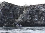
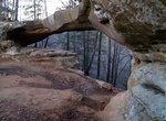
Climb Prince Philip's Steps, Genovesa Island, Galápagos
Prince Philip's Stepsis an extraordinary steep path that leads through a seabird colony full of life, up to cliffs that are 25 metres (82 feet) high. At the top, the trail continues inland, passing more seabird colonies in a thin palo santo forest. The trail also provides overviews of a rocky plain. Storm petrels here are different from any others in the world because... -
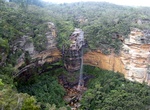
Hike to Princes Rock Lookout (Wentworth Falls), Blue Mountains, NSW, Australia
Hike to Princes Rock Lookout to see the entire drop of Wentworth Falls. Wentworth Falls drop 187 meters to the valley below. -
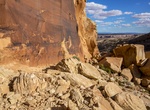
Hike Princess Arch Trail, Red River Gorge, Kentucky
Princess Arch Trail #233 extends along a dry wooded ridge to the scenic Princess Arch. The trail is located in the Red River Gorge on Cumberland Ranger District. The cliffs in the Red River Gorge are beautiful, but they can be dangerous if you step too close to the edge. Each year, someone is seriously injured or killed from falling off a cliff in the Red River Gorg... -
Hike to Procession Panel, Comb Ridge, Utah
Procession Panel is located along a southwest facing cliff, high atop Comb Ridge. It depicts 179 human-like forms and animals including mountain sheep, deer and/or elk and snakes. It's a 2.8 miles (round trip) to the panel. -
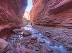
Hike Professor Creek and Mary Jane Canyon Trail, Utah
Professor Creek and Mary Jane Canyon Trail is a 8.4 mile trail located near Moab, Utah. Professor Creek is shallow for most of its length but one mile of the central section becomes fairly narrow and up to 100 feet deep. -
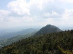
Hike Profile Trail (Grandfather Mountain), Sugar Mountain, North Carolina
The eight-mile roundtripProfile Trail begins at the Grandfather Mountain State Park parking area on N.C. Highway 105 near Sugar Mountain. The Profile Trail steadily climbs 1,775 feet through startling terrain with waterfalls and a mile-high swinging bridge. -
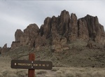
Hike Prospector's View Trail, Lost Dutchman State Park, Arizona
Prospector's View Trail #57 is 0.7 miles one way and rated moderate. It connects Siphon Draw Trail with Treasure Loop Trail also connects with Jacob's Crosscut Trail. Please use caution when hiking at the park. Those planning to use the longer trails should carry a topographic map. Each person should carry at least one gallon of drinking water per day. Remember summe... -
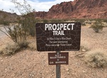
Hike Prospect Trail, Valley of Fire State Park, Nevada
Description: Newly marked, the Prospect Trail in Valley of Fire State Park connects the Atlatl Rock area with the White Dome area. The trail passes through interesting sandstone formations, rock canyons, as well as an earthquake zone--so named because of the many house-sized boulders that lay precariously above the trail. If you want to play a fun game with your fell... -
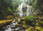
Hike to Proxy Falls, Oregon
Proxy Falls, also known as Lower Proxy Falls, is a cascade and plunge waterfall from a collection of springs on the shoulder of North Sister, that plunges into a gaping canyon near McKenzie Pass in the Willamette National Forest, near Belknap Springs, Oregon. The waterfall is notable for its main drop of 226 feet (69 m) which makes it one of the highest plunge waterfa... -
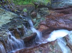
Hike to Ptarmigan Falls, Glacier National Park, Montana
Ptarmigan Falls is location at mile 2.1 along the Iceberg-Ptarmigan Trailhead, Glacier National Park, Montan. Just beyond the Ptarmigan Fallsis a well built foot bridge that crosses Ptarmigan Creek. -
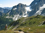
Trek Ptarmigan Traverse, Washington
The Ptarmigan Traverse is a famous alpine climbing route in Washington State's North Cascades. The route, from Cascade Pass to Dome Peak, is generally remote, unmarked, and challenging, traversing rugged terrain and several glaciers. The first traverse took 13 days in July 1938. The group consisted of four members of the Ptarmigan Climbing Club: Bill Cox, Calder Bress... -
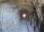
Hike Ptarmigan Tunnel Trail, Glacier National Park, Montana
Swiftcurrent Motor Inn parking lot (Many Glacier Area) to Ptarmigan Tunnel is 5.1 mile trail (one-way) in Glacier National Park. The Ptarmigan Tunnel was built in 1930 through the Ptarmigan Wall at an elevation of 7,200 feet (2,200 m) in Glacier National Park, near Many Glacier. The 250-foot (76 m) tunnel allows hikers to avoid a strenuous climb over very steep terrai... -
Summit Pucajirca, Peru
Pucajirca or Pucahirca (possibly from Quechuapukared, Ancash Quechuahirkamountain, "red mountain") is a mountain in the Cordillera Blanca in the Andes of Peru, about 6,046 m (19,836 ft) high. It is located in the Ancash Region, Pomabamba Province, Pomabamba District (Pucajirca Norte) as well as in the Huaylas Province, Yuracmarca District (Pucajirca Central) north of ...
Price: $167.71