Give us feedback!


 See all

Our philosophy is simple. We want to encourage you to dream. BIG! Then we help you plan your trip, get the most out of it while you're traveling and help you share your experience with friends.
Join Now It's FREE
Dream Packages
Duration: 14 hours
Price: $341.00
Price: $341.00
Duration: 8 hours
Price: $214.32
Price: $214.32
Duration: 6 to 10 hours
Price: $86.83
Price: $86.83
Duration: 10 hours
Price: $224.21
Price: $224.21
Related Categories
- Australian National Parks & Reserves
- Canadian National Parks
- Canyoneering
- Day Hikes
- Guided Hikes
- In the Mountains
- Mountaineering
- Mountains
- New Zealand Great Walks
- New Zealand National Parks
- Parks & Reserves
- Rock Climbing
- South African National Parks
- UK National Parks
- UNESCO Parks & Preserves
- US Historical Parks (NHP)
Dreams Still To Do
Checked-Off Dreams
Dreams Still To Do
Checked-Off Dreams
Advertisement
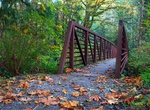
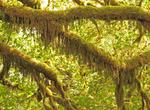
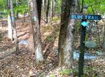
Explore Hikes & Treks
-
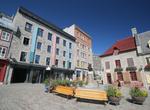
Hike around Quebec City
Exploring Québec City's history can be an all-consuming pastime, and a rewarding one. The walk outlined below takes you through much of it, but sticking slavishly to a route would be a mistake. The Old City is full of inviting little detours and alleyways. Don't bother resisting them. Highlights: Exploring La Citadelle; leisurely strolling along the Terrasse Du... -
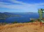
Hike or Mountain Bike Queen Charlotte Track, Marlborough Sounds, New Zealand
The Queen Charlotte Track, located at the top of New Zealands South Island in the Marlborough Sounds is a 71km-long trek (hike) between the Queen Charlotte and Keneperu Sound. The track stretching from Ship Cove to Anakiwa offers lush coastal forest and skyline ridges with unsurpassed views of the islands and bays of the sounds. It can be done in either direction, but... -
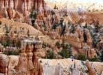
Hike Queens Garden/Navajo Loop Combination Trail, Bryce Canyon National Park, Utah
The Navajo Loop Trail closely follows its original alignment, leading to the "Wall Street" section of the amphitheater. The Queen's Garden Trail covers the area between Sunrise and Sunset Points, leading to the Queen Victoria rock formation. The trail includes two tunnels. The National Park System recommends starting at Sunset Point. Hike north (left) along the canyo... -
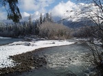
Hike Queets River Trail, Olympic National Park, Washington
The Queets River Trail is 15.8 miles to end of trail. A river ford is required to access the Queets from the trailhead. This crossing can be difficult or impossible during periods of heavy rain or snow melt. It is commonly waist deep in summer. The Lower Queets Road provides access as far as Matheny Creek; the road is closed beyond that due to a major land slide. The ... -
Hike Quinault Loop Trail, Olympic National Park, Washington
Quinault Loop Trail is a 3.9 mile loop trail located near Quinault Ranger Station and Quinault Lodge. -
Explore Quinault Rain Forest, Olympic National Park, Washington
The Quinault Rain Forest is a temperate rain forest, which is part of the Olympic National Park and the Olympic National Forest in the U.S. state of Washington in Grays Harbor County and Jefferson County. The rain forest is located in the valley formed by the Quinault River and Lake Quinault. The valley is called the "Valley of the Rain Forest Giants" because of the n... -
Hike Quinnipiac Trail, Connecticut
The Quinnipiac Trail is a 24-mile Blue-Blazed hiking trail in New Haven County, Connecticut. It is the product of the evolution and growth of the first 10.6-mile (17.1 km) trail designated in Connecticut's Blue-Blazed Hiking Trail system, with its light-blue rectangular vertical painted blazes . From its southeastern trailhead, its easternmost leg runs northward, para... -
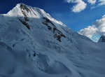
Summit Quitaraju, Huascarán National Park, Peru
Quitaraju or Kitaraju (possibly from Ancash Quechuakitadam, Quechuarahusnow, ice) is a mountain in the Cordillera Blanca in the Andes of Peru, about 6,040 metres (19,816 ft) high. It is situated in the Ancash Region, Huaylas Province, Santa Cruz District. Quitaraju lies north of the Santa Cruz Creek and the lakes named Ichiccocha, Jatuncocha and Quitacocha, between Sa... -
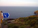
Hike Raad ny Foillan (The Way of the Gull), Isle of Man
Raad ny Foillan (The Way of the Gull) is a long distance footpath in the Isle of Man. The Raad ny Foillan starts and finishes at the Millennium Bridge over Douglas Harbour. The circular path, which is 95 miles in length, is way marked around the Manx coast on signs showing a gull on a blue background. The walk was created to mark the Island's "Heritage Year" celebrati... -
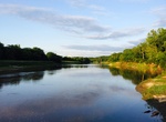
Hike Racoon River Park Loop, Des Moines, Iowa
The Raccoon River is a 30.8-mile-long (49.6 km) tributary of the Des Moines River in central Iowa in the United States. As measured using the longest of its three forks, its length increases to 226 miles (364 km). Via the Des Moines River, it is part of the watershed of the Mississippi River. The river runs through an intensely cultivated area of croplands and livesto... -
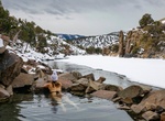
Hike or Raft to Radium Hot Springs, Kremmling, Colorado
Radium Hot Springs is a primitive warm springs pool located on the banks of the Colorado River. The spring mixes with river water bringing the temperature down to about 80⁰ F. Located some 100 miles west of Denver. The closest city to Radium to the north is Kremmling and to the south is Eagle and Edwards. -
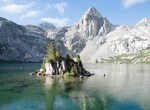
Hike Rae Lakes Loop, Kings Canyon National Park, California
The Rae Lakes Loop is one of the most popular hikes in Sequoia and Kings Canyon, if not in the entire Sierra. The loop is 41.4 miles long, and climbs from 5035' (1535m) at the trailhead to 11,978' (3651m) at Glen Pass. It is most often accessed via the Wood's Creek trailhead (clockwise) or the Bubb's Creek trailhead (counter clockwise). High water at stream crossings ... -
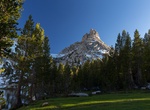
Climb Ragged Peak (Yosemite National Park), California
Ragged Peak is a mountain, in the Tuolumne Meadows area of Yosemite National Park. Of the ridge south of the Young Lakes region, Ragged Peak is the most prominent feature. It is 4 miles (6.4 km) north of Tioga Road and its summit has a great view of Mount Conness's southwest face. Ragged Peak is an isolated summit, close to Young Lakes. Ragged Peak is north of Lembert... -
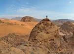
Explore Rahma (Rahmeh) Desert, Jordan
Rahma (Rahmeh) offers beautiful dunes, hills, rocky outcrops and is one of the most impressive and pristine deserts in Jordan. -
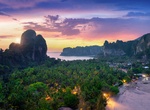
Climb Railay Viewpoint, Krabi, Thailand
Railay View point is a demanding hike, sometimes you even have to climb. There are slippery rocks that you have to walk on, ropes that you should hold on to and it might seem dangerous at first glance. Have full, comfortable shoes on and no fear. The view at the top is stunning and makes a perfect reward for the effort!
Price: $289.36