Give us feedback!


 See all

Our philosophy is simple. We want to encourage you to dream. BIG! Then we help you plan your trip, get the most out of it while you're traveling and help you share your experience with friends.
Join Now It's FREE
Dream Packages
Duration: 4 days
Price: $1457.59
Price: $1457.59
Duration: 6 hours 30 minutes
Price: $167.71
Price: $167.71
Duration: 10 hours
Price: $121.33
Price: $121.33
Duration: 2 days
Price: $398.24
Price: $398.24
Related Categories
- Australian National Parks & Reserves
- Canadian National Parks
- Canyoneering
- Day Hikes
- Guided Hikes
- In the Mountains
- Mountaineering
- Mountains
- New Zealand Great Walks
- New Zealand National Parks
- Parks & Reserves
- Rock Climbing
- South African National Parks
- UK National Parks
- UNESCO Parks & Preserves
- US Historical Parks (NHP)
Dreams Still To Do
Checked-Off Dreams
Dreams Still To Do
Checked-Off Dreams
Advertisement
Explore Hikes & Treks
-
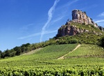
Summit Rock of Solutré, France
The Rock of Solutré (Roche de Solutré), is a limestone escarpment 8 km (5.0 mi) west of Mâcon overlooking the commune of Solutré-Pouilly and an iconic site of the Saône-et-Loire, in the south of the Bourgogne in France. Protected by the French law onsites classésand currently at the heart of aGrand Site Nationaloperation, it dra... -
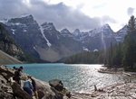
Hike Rockpile Trail (Moraine Lake), Banff National Park, Canada
Moraine Lake's Rockpile Trail along the actual moraine is approximately 300 metres long, with an elevation change of 24 metres (79 ft). The view of the lake from the top of the rockpile is one of the most photographed locations in all of Canada. That view of the mountains behind the lake in Valley of the Ten Peaks is known as the Twenty Dollar View, as Moraine Lake wa... -
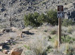
Hike Rock Spring Loop Trail, Mojave National Preserve, California
If you were wondering how anyone could-or would want to-live in the remote desert that is now Mojave National Preserve, take a walk along the Rock Spring Loop to find some answers. The Rock House was constructed by Bert Smith in 1929. He came to this area to recover from poison gas exposure suffered during World War I. Doctors told him he didn't have long to live, bu... -
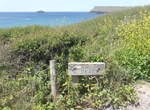
Hike Rock to Polzeath, Cornwall, England
Rock to Polzeath is about 5.2 miles long and located near United Kingdom. The trail is great for walking, taking in cracking views, playing in sand dunes and just having a lovely stroll. Source: Everytrail -
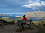
Hike to Rocky Mountain Lake Wanaka Viewpoint, Wanaka, New Zealand
Rocky Mountain Lake Wanaka Viewpoint overlooks Diamond Lake, Rocky Mountain and Parkins Bay (Lake Wanaka). -
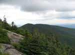
Summit Rocky Peak Ridge, New York
Rocky Peak Ridge is the twentieth highest peak in the High Peaks Region of the Adirondack Park of New York, USA. The name of the mountain is due to its geology, a rocky ridge to the east of the better known Giant Mountain. The long, bare ridge is unusual in the Adirondacks; it resulted from the last great forest fire in the region, in 1913. Ascents There are two trail... -
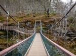
Hike to Rogie Falls, Scotland
Rogie Falls are a series of waterfalls on the Black Water, a river in Ross-shire in the Highlands of Scotland. The falls are about 2 km north-west of the village of Contin, next to the A835 road. They are a popular tourist attraction, with several forest walks. The bridge will support a maximum of five persons at one time, with a narrow and sharp set of steps at its e... -
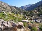
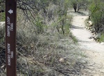
Hike Romero Canyon, Arizona
Romero Canyon is located in the Santa Catalina Mountains and part of the Coronado National Forest. A popular hiking trail leads to the Romero Pools, which hold water even during the driest parts of the season. The trailhead for the Romero Canyon Trail is located in the Catalina State Park. It is possible to hike throughout the Santa Catalinas on the network of trails.... -
Hike or Ride Romero Canyon Trail, Catalina State Park, Arizona
Romero Canyon Trail is a 7.2 miles, one-way trail in Catalina State Park. No dogs in Desert Bighorn Sheep Management Area, beyond Montrose Pools — no bikes in the Pusch Ridge Wilderness — not recommended for horses beyond Montrose Pools Progressively difficult trail. Montrose Pools and Romeo Pools are shallow catchments on canyon streams that flow seasona... -
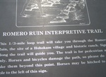
Hike Romero Ruins Interpretive Trail, Catalina State Park, Arizona
Romero Ruins Interpretive Trail is an easy 0.75 mile loop which begins south of the main road across from the second pull-out. The trail crosses a seasonal wash (feet may get wet) before climbing about 80 steps to the hilltop. The Romero Ruins archaeological site includes the surface features of the remains from a Hohokam village dating back to about 500 A.D. Trailsid... -
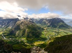
Hike Romsdalseggen, Norway
Romsdalseggen ridge is one of the world’s most scenic hikes. This hike through the dramatic landscape features many highlights. From the ridge, you can see the majestic Trollveggen cliff, surrounded by a number of well-known mountains. Romsdalseggen ridge is one of the most spectacular backdrops in the world, not far from the mountaineering capital Åndalsn... -
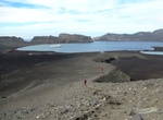
Hike Ronald Hill, Whalers Bay, Deception Island, Antarctica
Ronald Hill is a rocky, ice-free hill, 105 m in height, standing north of Kroner Lake on Deception Island, in the South Shetland Islands of Antarctica. It was charted, photographed and named by Olaf Holtedahl of the Norwegian expedition 1927–28, after the floating factory SS Ronald, which belonged to the Hektor Whaling Company. and was anchored at Deception Isla... -
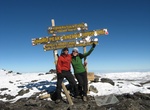
Trek Rongai Route, Mount Kilimanjaro, Tanzania
The Rongai route is the only route that approaches Kilimanjaro from the north, close to the Kenyan border. The route described below includes the 'Mawenzi Tarn Hut variation' which is recommended for acclimatization. However, some tours skip this and proceed directly from Simba camp to a 'Third Camp' at around 3700m to Kibo Hut, resulting in a (more difficult because ... -
Hike Roof Trail, Jewel Cave National Monument, South Dakota
The trail begins at the covered patio area outside the Jewel Cave National Monument Visitor Center lobby and returns to the north end of the visitor center. This trail lets one discover how the monument's surface and sub-surface resources interact. As you wind your way through the Ponderosa pines, imagine the cave below you, stretching in every direction. An overlook ... -
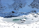
Hike to Roopkund (Skeletons Lake), India
Roopkund (locally known as Mystery Lake, Skeletons Lake) is a high altitude glacial lake in the Uttarakhand state of India. It lies in the lap of Trishul massif and is famous for the hundreds of human skeletons found at the edge of the lake. The area is uninhabited, in the Himalayas at an altitude of 5,029 metres (16,499 feet). Surrounded by rock-strewn glaciers and s...
Price: $224.21