Give us feedback!


 See all

Our philosophy is simple. We want to encourage you to dream. BIG! Then we help you plan your trip, get the most out of it while you're traveling and help you share your experience with friends.
Join Now It's FREE
Dream Packages
Duration: 4 hours
Price: $149.99
Price: $149.99
Duration: 6 hours 30 minutes
Price: $167.71
Price: $167.71
Duration: 12 hours
Price: $160.26
Price: $160.26
Duration: 30 minutes
Price: $263.77
Price: $263.77
Related Categories
- Australian National Parks & Reserves
- Canadian National Parks
- Canyoneering
- Day Hikes
- Guided Hikes
- In the Mountains
- Mountaineering
- Mountains
- New Zealand Great Walks
- New Zealand National Parks
- Parks & Reserves
- Rock Climbing
- South African National Parks
- UK National Parks
- UNESCO Parks & Preserves
- US Historical Parks (NHP)
Dreams Still To Do
Checked-Off Dreams
Dreams Still To Do
Checked-Off Dreams
Advertisement
Explore Hikes & Treks
-
Hike Rider Canyon, Grand Canyon National Park, Arizona
Rider Canyon feeds into Marble Canyon on the Colorado River in Arizona. It's scenic canyon with narrows and potholes and has some steep scrambling to get in and out of the canyon. The hike is 5.5 miles rountrip and take 4-5 hours. Ropes are not required for the hike but there are some semi-technical climbs and scrambles to make it to the river. To get there drive... -
Stroll Riegelmann Boardwalk (Coney Island Boardwalk), Coney Island, New York City, New York
The Riegelmann Boardwalk (also known as the Coney Island Boardwalk) is a 2.7-mile-long (4.3 km) boardwalk along the southern shore of the Coney Island peninsula in the New York City borough of Brooklyn, facing the Atlantic Ocean. Opened in 1923, the boardwalk runs between West 37th Street at the edge of the Sea Gate neighborhood to the west and Brighton 15th Street in... -
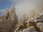
Hike to Rifugio Torre Di Pisa, Italian Dolomites
Take the 2-3 hour hike to the Torre di Pisa hut in the Italian Dolomites. It's the only mountain refuge in the Latemar group and is perched on Cavignon peak at 2671 Meters a.s.l. The sight you can enjoy from there is really incomparable. Near the hut you can see a 20-meter-high leaning pinnacle which looks like the famous leaning tower of the cathedral of Pisa. I... -
Hike Riggs Spring Loop Trail, Bryce Canyon National Park, Utah
The Riggs Spring Fire Trail, also known as the Riggs Spring Loop Trail, was built in Bryce Canyon National Park in 1936 to provide access to the park's backcountry for fire suppression crews. The approximately 8-mile (13 km) trail is significant for its association with Civilian Conservation Corps labor from CCC Camp NP-3, and represents the last link in the series of... -
Hike Rila Mountains, Sofia, Bulgaria
Rila is the highest mountain range of Bulgaria and the Balkan Peninsula. It is situated in southwestern Bulgaria and forms part of the Rila–Rhodope Massif. The highest summit is Musala at an altitude of 2,925 m which makes Rila the sixth highest mountain range in Europe after the Caucasus, the Alps, Sierra Nevada, the Pyrenees and Mount Etna, and the highest one... -
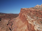
Hike Rim Overlook & Navajo Knobs Trails, Capitol Reef National Park, Utah
Rim Overlook & Navajo Knobs Trails are located within Capitol Reef National Park, Utah. The Strenuous 2.3 mi (3.6 km) Rim Overlook Trail has an elevation gain of 1,110 ft (338 m) and provides panoramas of Fruita and Waterpocket Fold from atop dramatic cliff. The 4.7 mi (7.6 km) Navajo Knobs Trail (1,620 ft (494 m)) is a continuation of Rim Overlook Trail, 360-degr... -
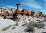
Hike to Rimrock Hoodoos, Utah
Rimrock Hoodoos are a wonderful and easily accessed cove contains darker versions as well as magnificent pearly white columns of the Wahweap Hoodoos. From Big Water, drive 12 miles west on Highway 89. Look for a small parking area and trailhead kiosk on the right side (north) of the road. -
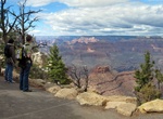
Hike Rim Trail, Grand Canyon National Park, Arizona
The Rim Trail is a hiking trail located on the South Rim of the Grand Canyon National Park, located in the U.S. state of Arizona. It is a 0,.9 trail between the South Kaibab Trailhead west to Hermit's Rest. Any section of the Rim Trail you will find jaw-dropping looks into the Grand Canyon, but the unpaved section between Maricopa Point and Hermits Rest is a dirt... -
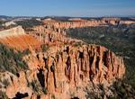
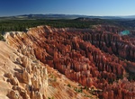
Hike Rim Trail, Bryce Canyon National Park, Utah
The Rim Trail offers hikers the opportunity to see Bryce from on top. The entire Rim Trail extending from Fairyland to Bryce Point has several steep elevation changes and is 5.5 miles/9.16 kilometers one way. -
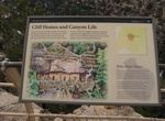
Hike Rim Trail (Walnut Canyon), Arizona
Stroll along the canyon rim through a mixed juniper and pinion pine forest. Two canyon overlooks provide scenic views of the canyon and cliff dwellings below. Explore a partially rebuilt pithouse and pueblo set back from the canyon rim. On a summers day, visit the demonstration garden that features traditional crops grown by the Sinagua. Do your part to protect the p... -
Hike or Mountain Bike Rimutaka Rail Trail, New Zealand
The Rimutaka Rail Trail is a walking and cycling track in the North Island of New Zealand. It runs between Maymorn and Cross Creek, and follows 22 kilometres (14 mi) of the original route of the Wairarapa Line over the Rimutaka Ranges between the Mangaroa Valley and the Wairarapa, including the world-famous Rimutaka Incline. Parts of the trail are also used by vehicle... -
Hike Rinconada Canyon Trail, Petroglyph National Monument, New Mexico
The longest petroglyph viewing trail system in Petroglyph National Monument, this moderate undeveloped trail is 2.2 miles round-trip. Water is not available. Vault restroom facility is available at the trail head. See approximately 300 petroglyphs in 1.5-2 hours. Leashed pets allowed. Parking lot is open 8:00 am to 5:00 pm daily. A free trail guide is available at th... -
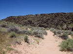
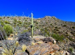
Hike Rincon Mountains Trails, Saguaro National Park, Arizona
The Rincon Mountains are a significant mountain range east of Tucson, Pima County, Arizona, in the United States. The Rincon Mountains are one of five mountain ranges surrounding the Tucson valley. The other ranges include the most prominent, the Santa Catalina Mountains to the north, the Santa Rita Mountains to the south, the Tucson Mountains to the west, and the Tor... -
Hike Rio Grande Village Nature Trail, Big Bend National Park, Texas
Although short and easy, the trail is very scenic and has fantastic opportunities for wildlife viewing, especially birds. The first 100 yards is wheelchair accessible and crosses a boardwalk through a spring-fed wetland. Then the trail gradually climbs a limestone hill with panoramic vistas of the Rio Grande, and the Chisos and Del Carmen Mountains. This trail is grea... -
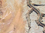
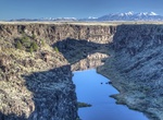
Explore Rio Grande Wild and Scenic River (New Mexico)
The Rнo Grande Wild and Scenic River, located within the Rнo Grande del Norte National Monument, includes 74 miles of the river as it passes through the 800-foot deep Rнo Grande Gorge. Flowing out of the snowcapped Rocky Mountains in Colorado, the river journeys 1,900 miles to the Gulf of Mexico. Here the river flows in a rugged and scenic part of northern New Mexico....


Price: $86.83