Give us feedback!


 See all

Our philosophy is simple. We want to encourage you to dream. BIG! Then we help you plan your trip, get the most out of it while you're traveling and help you share your experience with friends.
Join Now It's FREE
Dream Packages
Duration: 13 hours 30 minutes
Price: $572.77
Price: $572.77
Duration: 4 days
Price: $663.61
Price: $663.61
Duration: 12 hours
Price: $224.21
Price: $224.21
Duration: 10 hours
Price: $199.57
Price: $199.57
Related Categories
- Australian National Parks & Reserves
- Canadian National Parks
- Canyoneering
- Day Hikes
- Guided Hikes
- In the Mountains
- Mountaineering
- Mountains
- New Zealand Great Walks
- New Zealand National Parks
- Parks & Reserves
- Rock Climbing
- South African National Parks
- UK National Parks
- UNESCO Parks & Preserves
- US Historical Parks (NHP)
Dreams Still To Do
Checked-Off Dreams
Dreams Still To Do
Checked-Off Dreams
Advertisement
Explore Hikes & Treks
-
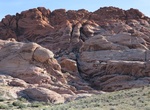
Explore Red Rock Canyon National Conservation Area, Nevada
Red Rock Canyon National Conservation Area in Nevada located about 15 miles (24 km) west of Las Vegas, and easily seen from the Las Vegas Strip. The conservation area showcases a set of large red rock formations: a set of sandstone peaks and walls called the Keystone Thrust. The walls are up to 3,000 feet (910 m) high, making them a popular hiking and rock climbing d... -
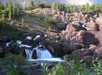
Hike to Red Rock Falls, Glacier National Park, Montana
Red Rock Falls is located along the Swiftcurrent Pass Trail in Glacier National Park, Montana. -
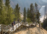
Visit Red Rock Point Trail, Yellowstone National Park, Wyoming
The Red Rock Trail takes the hardy visitor partway into the canyon where Lower Falls roars closer and more dramatic than ever. The trail can be seen in the bottom part of this phoo. To reach this trail from the parking lot, bear right at the fork. The trail includes many steps and drops 500 feet (150 m) in about .38 miles (0.6 km) and is not recommended for visitors w... -
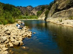
Swim at Red Rock Pools (Santa Ynez River), California
Up river to Gibraltar reservoir. The " low road" is considered the Red Rock trail and follows the river. You will find several large swimming holes along the trail. The most popular pool "Red Rock Pools" is 1/2 mile from the trailhead and can be crowded with visitors on weekends. The more secluded pools are further upriver. Combine the low road and the high road for a... -
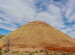
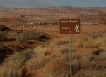
Hike Red Scar Knoll Trail, John Day Fossil Beds National Monument, Oregon
The Red Scar Knoll Trail is 0.25 mile / 0.4 km roundtrip. This mostly level trail leads to a hill of bright yellow and red clays. This trailhead is called Red Hill on the road signs. -
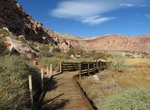
Walk Red Spring Boardwalk, Red Rock Canyon, Nevada
Red Spring Boardwalk is a 0.55-mile boardwalk circles an out-of-place meadow fed by a small spring. Red Spring spills from the base of the Calico Hills beneath a ridge of wildly shaped sandstone. Red Spring Boardwalk is off Calico Basin Road on the east side of the park. -
Hike Redstone Picnic Area and Dune Trail, Nevada
Redstone is located just off Northshore Road (Hwy 167) at mile marker 27. Drive straight to the picnic area, park, and hike the easy half-mile trail or climb along the red sandstone outcroppings and ancient lava flows. Distance: 0.5 miles Picnic Area Info: 3 shade areas 3 grills 1 restroom 3 picnic tables No drinking water -
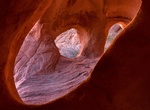
Hike Red Tanks Tanaja Trail, Organ Pipe Cactus National Monument, Arizona
Red Tanks Tinaja, reached by a trail starting near mile 4 along the Puerto Blanco Drive. Red Tanks Tinaja is a natural cavity along a small wash on the north side, where water remains for a long time after rainfall. During the winter season, free hiker shuttles are offered to the Senita Basin and Red Tanks Tinaja Trailhead. From these trails, one can easily walk back... -
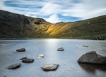
Hike to Red Tarn, Lake District, England
Red Tarn is a small lake in the eastern region of the English Lake District, in the county of Cumbria. It is high up on the eastern flank of Helvellyn, beneath Striding Edge and Catstye Cam. Red Tarn was formed when the glacier that carved out the eastern side of Helvellyn had melted. The lake along with three others in Lake District is a habitat for the very rare and... -
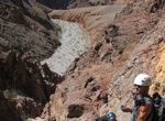
Hike Red Wall Canyon, Death Valley National Park, California
Red Wall Canyon is located north of Titus Canyon in Death Valley National Park, California. The streamway passes dryfalls, narrow channels, twisted igneous rock formations and variously textured walls with red the dominant color. There is no road to the entrance nor even a signpost. The trailhead is on the park road, 4.3 miles north of the signed turn-off to Fall/Tit... -
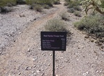
Hike Red Wash Trail, Bullfrog, Utah
A sandy hike that involves rock scrambling to lead in and out of the wash. Great beginner trail that illustrates how the power of water formed much of the local landscape. Be prepared to get muddy and wet. WARNING: Do not hike when there is a potential for flash flooding.Trailhead: Access near the Bullfrog Visitor Center. Located approximately 100 miles south of Inter... -
Hike Redwood Canyon Trail, Garland Ranch Regional Park, Carmel Valley, California
This is a fun moderate hike to Redwood Canyon. Starts through a beautiful oak grove. A lot of wildflowers in bloom in the spring, and a small patch of Redwood trees and ferns with that incredible smell you only get in redwood groves. -
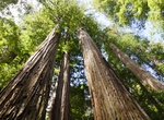
Hike Redwood Creek Trail, Redwood National and State Parks, California
Redwood Creek Trail is the second most-visited trail in Redwood National Park, after the Lady Bird Johnson Trail. There are not many redwoods grow along the trail, but the 8 mile (one-way) hike leads to Tall Trees Grove, home of the Libbey Tree (363 feet high) and other giants. The most scenic part of the trail is the first 1.5 miles up to the first creek crossing. T... -
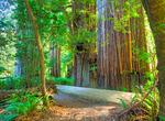
Hike Redwood Trail, Big Basin Redwoods State Park, California
The Redwood Trail at Big Basin Redwoods State Park loop offers easy access to some of the tallest and oldest Redwoods anywhere. The fact that the trail is flat and well-maintained, combined with the well-marked attractions along the way make this a perfect hike for families with young children. Loop, self-guided nature trail. Trail guides available at HQ and the trai... -
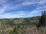
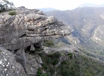
Hike to Reeds Lookout & The Balconies, Grampians National Park, Victoria, Australia
Hike to Reeds Lookout for some great views overlooking the Victoria Valley. Drive up Northern Grampians Road to the Reeds Lookout Carpark. Park the car and follow the 100m path around the gate and along the sealed road to the summit of Reeds Lookout. Hike the 2 km loop to the The Balconies for more panoramic views over the Victoria Valley. The track climbs gently fro...
Price: $398.24