Give us feedback!


 See all

Our philosophy is simple. We want to encourage you to dream. BIG! Then we help you plan your trip, get the most out of it while you're traveling and help you share your experience with friends.
Join Now It's FREE
Dream Packages
Duration: 6 days
Price: $606.00
Price: $606.00
Duration: 12 hours 30 minutes
Price: $289.36
Price: $289.36
Duration: 12 hours
Price: $160.26
Price: $160.26
Duration: 4 hours
Price: $129.99
Price: $129.99
Related Categories
- Australian National Parks & Reserves
- Canadian National Parks
- Canyoneering
- Day Hikes
- Guided Hikes
- In the Mountains
- Mountaineering
- Mountains
- New Zealand Great Walks
- New Zealand National Parks
- Parks & Reserves
- Rock Climbing
- South African National Parks
- UK National Parks
- UNESCO Parks & Preserves
- US Historical Parks (NHP)
Dreams Still To Do
Checked-Off Dreams
Dreams Still To Do
Checked-Off Dreams
Advertisement
Explore Hikes & Treks
-
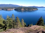
Hike to Ripple Rock Lookout, Seymour Narrows, British Columbia, Canada
Ripple Rock is an underwater mountain located in the Seymour Narrows of the Discovery Passage in British Columbia, Canada. It had two peaks (2.74 metres and 6.4 metres below the surface at low tide) that produced large, dangerous eddies from the strong tidal currents that flowed around them at low tide. Ships transiting the strait preferred to wait until slack tide in... -
Explore Riserva Naturale dello Zingaro, Sicily, Italy
Riserva naturale dello zingaro was the first natural reserve set up in Sicily in May 1981, located almost completely in the municipal territory of San Vito Lo Capo. It stretches along some seven kilometers of unspoilt coastline of the Gulf of Castellammare and its mountain chain, the setting of steep cliffs and little bays. The Zingaro Reserve has a large variety and ... -
Hike Rising Sun Trail, Solstice Canyon, Malibu, California
Rising Sun Trail is within Santa Monica Mountains National Recreation Area in Malibu, California This moderately difficult hike climbs northerly up the canyonside and provides views out to the Pacific Ocean. After descending into the canyon, the trail connects to the northern end to Solstice Canyon Trail near the burned remains of Roberts family home. Return to the T... -
Hike to Ritchie Ledges (Ice Box Cave), Cuyahoga Valley National Park, Ohio
The 1.0 mile hike to Ritchie Ledges (Ice Box Cave) in Cuyahoga Valley National Park, Ohio takes about an hour. The cool, moist hemlock and yellow birch forests along the towering sandstone Ritchie Ledges benefit from a microenvironment formed near the over 300-million-year-old rock formations. Enormous blocks of the orange and yellow rock have broken off and make you ... -
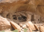
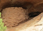
See River House (Snake House) Ruins, Comb Wash, Utah
River House is one of the better and more photogenic Anasazi ruins to be found in Cedar Ridge in Utah. -
Ride or Walk River Mountains Loop Trail, Nevada
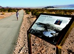
River Mountains Loop Trail is a must-do for cyclists and walkers alike. A 34-mile paved loop trail (16.7 miles of which are in Lake Mead National Recreation Area) boasts scenic views, plentiful wildlife and the vast beauty of the Mojave Desert. This trail has several trailheads and journeys around the river mountains connecting the park, as well as Hoover Dam, Henders... -
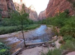
Hike Riverside Walk (Gateway to the Narrows Trail), Zion National Park, Utah
The Gateway to the Narrows Trail, also known as the Riverside Walk, is a relatively short nature trail of one mile along the Virgin River. It connects the parking area at the Temple of Sinawava with The Narrows and is listed on the National Register of Historic Places. The trail uses local materials such as red sandstone to blend with its surroundings, following the t... -
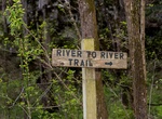
Hike River to River Trail, Illinois
The River to River Trail is a 160 mile (256 km)-long hiking trail that serves Shawnee National Forest in far southern Illinois. The trail is used by both equestrians and hikers. About half is on off road trails. Its eastern terminus has historically been Battery Rock, overlooking the Ohio River but now generally Elizabethtown, Illinois is used as the eastern terminus.... -
Hike River Trail, Congaree National Park, South Carolina
The River Trail in Congaree National Park, South Carolina is 10.4 miles (16.7 km) and takes 5.6 hours to complete. This trail takes you to the Congaree River, the lifeblood of the area's great natural diversity. About ten times a year, floodwaters from the river cover the park. Because much of the forest along the River Trail was logged prior to the park's establishme... -
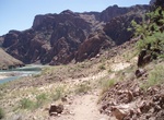
Hike River Trail, Grand Canyon National Park, Arizona
The River Trail is a 2 mile hiking trail in Grand Canyon National Park, located in the U.S. state of Arizona. Though it has no official trailhead, the River Trail is an important link in the trail system in Grand Canyon. This trail connects the Bright Angel Trail at its western terminus with Phantom Ranchand the Bright Angel Campground via the silver suspension b... -
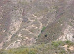
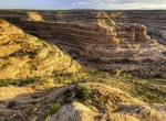
Hike Road Canyon, Cedar Mesa, Bears Ears National Monument, Utah
NOTE: A permit to hike or backpack is required. Road Canyon is accessed from the Cigarette Springs Road on Cedar Mesa. The elevation in the upper ends of Road Canyon begins at approximately 6,200 feet and drops to 4,900 feet at the lower ends. The walls of the canyon vary from 100 feet in the upper ends to over 500 feet in the lower ends. Erosion of the colorful Ceda... -
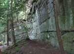
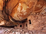
Hike Road Canyon to Fallen Roof Ruin, Cedar Mesa, Utah
Fallen Roof Ruin is located along Road Canyon in Cedar Mesa part of Bears Ears National Monument. It's a 3.0 miles (round trip) to the ruins. Hiking another 4.5 miles down the canyon will arrive at Seven Kivas Ruins. From the Kane Gulch Ranger Station, drive 9.0 miles south on State Route 261 to the Cigarette Springs Road. Turn east and drive 3.5 miles to an unma... -
Hike Roadside Ruin Trail, Canyonlands National Park, Utah
The Roadside Ruin Trail off Route 211 in Canyonlands National Park is a short, easy 0.3 miles (0.5km) walk. At the end there is an ancient granery and ancient petroglyphs in the area. It's located just west of Needles District Visitor Center. -
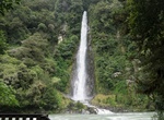
Hike to Roaring Billy Falls, Mount Aspiring National Park, New Zealand
Roaring Billy Falls is a 30-meter waterfall located in Mt Aspiring National Park, along HAAST Highway. -
See Roaring River Falls, Kings Canyon National Park, California
Feel the power of this short but mighty waterfall as it rushes through a narrow granite chute. The falls are are a short distance from the road along a paved trail.


Price: $263.77