Give us feedback!


 See all

Our philosophy is simple. We want to encourage you to dream. BIG! Then we help you plan your trip, get the most out of it while you're traveling and help you share your experience with friends.
Join Now It's FREE
Dream Packages
Duration: 4 hours
Price: $149.99
Price: $149.99
Duration: 3 hours 15 minutes
Price: $371.99
Price: $371.99
Duration: 10 hours
Price: $199.57
Price: $199.57
Duration: 2 days
Price: $469.00
Price: $469.00
Related Categories
- Australian National Parks & Reserves
- Canadian National Parks
- Canyoneering
- Day Hikes
- Guided Hikes
- In the Mountains
- Mountaineering
- Mountains
- New Zealand Great Walks
- New Zealand National Parks
- Parks & Reserves
- Rock Climbing
- South African National Parks
- UK National Parks
- UNESCO Parks & Preserves
- US Historical Parks (NHP)
Dreams Still To Do
Checked-Off Dreams
Dreams Still To Do
Checked-Off Dreams
Advertisement
Explore Hikes & Treks
-
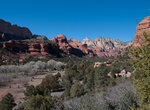
Hike to Boynton Vortex, Sedona, Arizona
To get to the Boynton Vortex, start at the Boyton Canyon Trailhead and then take the Boynton Vortex Trail. -
Hike Boy Scout Canyon to Two Mile Hot Springs, Nevada
If it’s hot springs you seek, there are two ways to get to Boy Scout springs. And unless you are an experienced rock climber, we only recommend the river route. The spring is accessible from Black Canyon by kayak. For the hikers amongst you, the intermediate 4-mile hike through Boy Scout Canyon leads you down a sandy wash into a beautiful desert canyon. It ends ... -
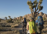
Hike Boy Scout Trail, Joshua Tree National Park, California
Go deep into the Wonderland of Rocks. Stay on trail to avoid getting lost among the boulders. Most hikers prefer to start at the south trailhead, inside the West Entrance, and finish at Indian Cove. Vehicle shuttle strongly recommended for hikers interested in doing the full length the trail. North end: Indian Cove backcountry board. South end: Boy Scout Trailhead (... -
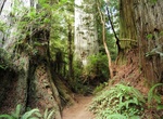
Hike Boy Scout Tree Trail, Jedediah Smith Redwoods State Park, California
This rewarding hike though old-growth redwoods is popular for those in the north wanting a bit of a challenge - both physically and logistically. Located in Jedediah Smith Redwoods State Park, visitors should consider this as a half-day experience to access and then walk this 5.5 mile round trip trail. During this walk, you will follow riperean areas, see "Fern Falls"... -
Hike Boyton Canyon Trail, Sedona, Arizona
Boynton Canyon is one of the most scenic of the box canyons that make Arizona Red Rock Country so famous. This particular trail enjoys the additional advantage of being conveniently accessible to nearby towns on well paved roads. As you might suspect, that is both good and bad news for those who choose to come here. The good news is you don't have to bounce down a dus... -
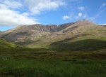
Summit Braeriach, Scotland
Braeriach is the third-highest mountain in the British Isles, surpassed only by Ben Nevis and Ben Macdui. It is the highest point in the western massif of the Cairngorms, separated from the central section (containing Ben Macdui and Cairn Gorm) by the pass of the Lairig Ghru. The summit has a crescent shape, with several corries. In the north-facing corrie of Garbh Co... -
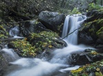
Hike to Brandy Creek Falls, Igo, California
This is a moderately steep trail leading uphill to Lower Brandy Creek Falls. The Brandy Creek Falls Trail takes the hiker along an old logging road, passing through the dense second-growth forest that is typical of this section of the park. Approximately 0.5 miles into the hike, you will reach a bridge at the fi rst of two small creeks. Large boulders and logs found a... -
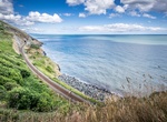
Hike Bray Head to Greystones Cliff Walk, Ireland
This is a magnificent coastline 7.1 km walk between Bray and Greystones with stunning views of the Irish Sea and Wicklow County. It takes between 1.5 and 2.5 hours, with a total of 130m climbed. The path is well maintained and you can return by light rail (DART) to the start point. -
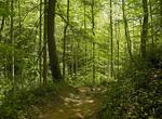
Hike Brevard Hiking Trail, Pisgah National Forest, North Carolina
Pisgah National Forest is a National Forest in the Appalachian Mountains of western North Carolina. It is administered by the United States Forest Service, part of the United States Department of Agriculture. The Pisgah National Forest is completely contained within the state of North Carolina. The forest is managed together with the other three North Carolina Nationa... -
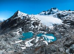
Hike Brewster Track to Brewster Glacier, New Zealand
This is a great hike to Brewster Glacier and its terminal lakes goes through a beautiful beech forest. The track starts from Fantail Falls, crosses the unbridged Haast River, and climbs steadily through beech forest to the bushline. It's 5 km out and back to Brewster Hut. It's another 5.3-mile out-and-backfrom Brewster Hut to Brewster Glacier. The best times to visi... -
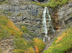
Hike to Bridal Veil Falls (Provo), Utah
Bridal Veil Falls is a 607-foot-tall (185 m) double cataract waterfall in the south end of Provo Canyon, close to US189 in Utah, United States. An aerial tramway service to the top of the falls was built in 1967 and the small, six-passenger tramway functioned as a recreational attraction and as the only access (except via helicopter) to a restaurant built by Groneman ... -
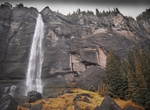
Hike to Bridal Veil Falls (Telluride), Colorado
Bridal Veil Falls is a 365-foot (111 m) waterfall at the end of the box canyon overlooking Telluride, Colorado. Hiking and off-road trails pass by the falls and the power plant at its top. In winter the frozen shape of the falls forms an imposing challenge to intrepid ice climbers. Bridal Veil Falls is a two pronged waterfall. The trail past the falls continues on to ... -
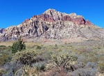
Off-road Bridge Mountain Trail, Red Rock Canyon, Nevada
Bridge Mountain Trail is accessible from the summit of Rocky Gap Road. Difficulty: challenging. Off-road/4x4 required. -
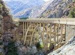
Hike to Bridge to Nowhere via East Fork Trail, San Gabriel Mountains, California
The Bridge to Nowhere is an arch bridge that was built in 1936 north of Azusa, California, United States, in the San Gabriel Mountains. It spans the East Fork of the San Gabriel River and was originally intended to be part of a road connecting the San Gabriel Valley with Wrightwood, California. The East Fork Road was still under construction when it was washed out dur... -
Hike or Ride Bridle Trail, Grand Canyon National Park, Arizona
The Bridle Trail 1.2 miles (2 km) one-way trail on the North Rim follows the road as it connects the Grand Canyon Lodge with the North Kaibab Trailhead. Hike or bicycle this hard-packed trail. Pets on leash are permitted.

Price: $572.77