Give us feedback!


 See all

Our philosophy is simple. We want to encourage you to dream. BIG! Then we help you plan your trip, get the most out of it while you're traveling and help you share your experience with friends.
Join Now It's FREE
Dream Packages
Duration: 10 hours
Price: $224.21
Price: $224.21
Duration: 2 days
Price: $398.24
Price: $398.24
Duration: 12 hours
Price: $160.26
Price: $160.26
Duration: 13 hours 30 minutes
Price: $572.77
Price: $572.77
Related Categories
- Australian National Parks & Reserves
- Canadian National Parks
- Canyoneering
- Day Hikes
- Guided Hikes
- In the Mountains
- Mountaineering
- Mountains
- New Zealand Great Walks
- New Zealand National Parks
- Parks & Reserves
- Rock Climbing
- South African National Parks
- UK National Parks
- UNESCO Parks & Preserves
- US Historical Parks (NHP)
Dreams Still To Do
Checked-Off Dreams
Dreams Still To Do
Checked-Off Dreams
Advertisement
Explore Hikes & Treks
-
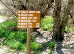
Hike or Ride Bridle Trail, Catalina State Park, Arizona
Bridle Trail is a 1.4 miles, one-way flat, easy trail connects the Equestrian Center with the Trailhead parking area. Plan on 45 minutes each way. -
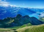
Summit Brienzer Rothorn, Switzerland
The Brienzer Rothorn is a mountain of the Emmental Alps, in Switzerland. With an elevation of 2,350 metres above sea level, the Brienzer Rothorn is the highest summit of the range. To its west lies the Tannhorn, whilst to its east are Arnihaaggen, Höch Gumme and the Brünig Pass (1,008 m). On its south side it overlooks Lake Brienz, whilst to the north it loo... -
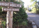
Hike to Bright Angel Point (Bright Angel Trail), Grand Canyon National Park, Arizona
The hike to Bright Angel Point on the Bright Angel Trail is a great day hike if your on the North Rim of the Grand Canyon National Park. The paved trail leads to a spectacular view of the canyon. The view confirms the tremendous uplift that has occurred, leaving the canyon’s North Rim 1,000 feet/300 meters higher than the South Rim. The trail is 0.5 mile (0... -
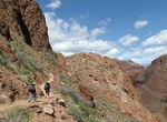
Hike Bright Angel Trail, Grand Canyon National Park, Arizona
The Bright Angel Trail is a hiking trail located in Grand Canyon National Park in the U.S. state of Arizona. The trail originates at the Grand Canyon Village on the south rim of Grand Canyon, descending 4380 feet to the Colorado River. It has an average grade of 10% along its entire length. At trail's end, the River Trail continues another 2 miles to the Bright Angel ... -
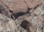
Hike to Brimhall Natural Bridge, Capitol Reef National Park
Brimhall Natural Bridge in Capitol Reef National Park, Utah requires a rugged hike through a narrow canyon. The route is largely unmarked, so carrying a topographic map is recommended. From the Halls Creek Overlook trailhead, the total round trip distance is 4.6 miles (7.4 km). The hike can be done as a long day hike. Backcountry permits are required for all overnigh... -
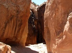
Hike Brimstone Gulch, Dry Fork, Coyote Gulch, Utah
Finally, further down the main Dry Fork wash in Utah, Brimstone Gulch exhibits many of the features of the larger slot canyons in the area. It is located within both the Grand Staircase-Escalante National Monument (upper sections) and the Glen Canyon National Recreation Area (lower sections). -
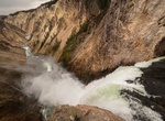
Hike Brink of Lower Falls Trail, Yellowstone National Park, Wyoming
Depending on the time of year, anywhere between 5,000 -60,000 gallons per second (18,927-22,7125 l/s) of water plunges 308 feet (93 m) over Lower Falls. You can catch a distant view of this power from some overlooks adjacent to the parking lot. Or you can descend to the brink on a steep trail that drops 600 feet (180 m). Not recommended for those with heart, lung, or ... -
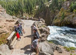
Hike Brink of the Upper Falls Trail, Yellowstone National Park, Wyoming
To reach this dramatic view, drive south from Canyon Junction on the Grand Loop Road and turn left onto the spur road. Shorter than Lower Falls, Upper Falls (109 ft/33 m) is impressive in its own way. As you walk toward the overlook, listen to the rush of water. Then proceed down the steps and around the corner to view the colliding currents rushing pell-mell over the... -
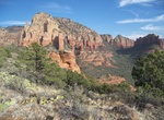
Hike Brin's Mesa Trail, Red Rock-Secret Mountain Wilderness, Arizona
Brin's Mesa Trail #119 (3 miles (4.8 km)) begins right at the edge of the town of Sedona and is as picturesque as it is convenient. Instead of keeping you tucked away in a deep canyon or clinging to the side of a steep slope as do a lot of other trails in this area, it leads you right out into the open where you can enjoy unobstructed views of the spectacular red rock... -
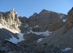
Hike Bristlecone and Glacier Trail, Great Basin National Park, Nevada
The Glacier Trail is the continuation of the Bristlecone Trail. It continues beyond the bristlecone pine grove to the only glacier in Nevada, nestled beneath Wheeler Peak. -
Hike Bristlecone Loop Trail, Bryce Canyon National Park, Utah
The Bristlecone Loop, accessible from Rainbow Point at the southern end of the park, meanders through the forest atop this highest portion of the park, reaching elevations over 9,100 feet (2778 m). Here you will pass by bristlecone pines up to 1,800-years-old and experience vistas reaching into the Four Corners area. The forest here is dominated by Blue Spruce, D... -
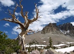
Hike Bristlecone Trail, Great Basin National Park, Nevada
The Bristlecone Trail starts at 9,800 feet (2,990 m) and has interpretive signs in the bristlecone pine grove explain the lives and significance of these ancient trees. The Wheeler Peak bristlecone pine grove, the most accessible grove in the park, is located on the northeast side of Wheeler Peak. It is unusual in that it grows on a glacial moraine consisting of quar... -
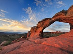
Hike Broken Arch Loop Trail, Arches National Park, Utah
Broken Arch in Arches National Park is an intact sandstone arch named for the central crack that gives it a fractured, overlapping appearance. From the trailhead at the Sand Dune Arch parking area, the trail crosses a large meadow to the arch and continues to the campground. Trail leads through fins with sand dunes and slickrock. The northern part of the loop includes... -
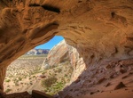
Hike to Broken Arrow Cave & Movie Set, Amangiri, Utah
One of two complimentary hikes offered daily by Amangiri Resort is the trek to Broken Arrow Cave (the site of the 1996 “Broken Arrow” film), a striking monolith featuring an ancient cave at its center. Remains from up to 8,000 years ago have been found, and guests can inspect animal and vegetal relics, sharpened rocks that were chiseled into weapons and ev... -
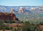
Off-Road or Hike Broken Arrow Trail, Sedona, Arizona
Broken Arrow Trail near Sedona is considered one of the best in Arizona. It's an extremely popular route and traffic can be very heavy at times. Many hikers will avoid this trail because of the jeep traffic on a road parallel to the trail, but it's still a great hike. At 0.6 miles, look for the fence around Devil's Dining Room Sinkhole 100 feet to the left and downhi...

Price: $341.00