Give us feedback!


 See all

Our philosophy is simple. We want to encourage you to dream. BIG! Then we help you plan your trip, get the most out of it while you're traveling and help you share your experience with friends.
Join Now It's FREE
Dream Packages
Duration: 8 hours
Price: $214.32
Price: $214.32
Duration: 4 days
Price: $772.57
Price: $772.57
Duration: 4 days
Price: $663.61
Price: $663.61
Duration: 14 hours
Price: $341.00
Price: $341.00
Related Categories
- Australian National Parks & Reserves
- Canadian National Parks
- Canyoneering
- Day Hikes
- Guided Hikes
- In the Mountains
- Mountaineering
- Mountains
- New Zealand Great Walks
- New Zealand National Parks
- Parks & Reserves
- Rock Climbing
- South African National Parks
- UK National Parks
- UNESCO Parks & Preserves
- US Historical Parks (NHP)
Dreams Still To Do
Checked-Off Dreams
Dreams Still To Do
Checked-Off Dreams
Advertisement
Explore Hikes & Treks
-
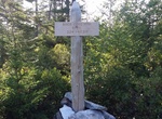
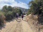
Hike Buck Cove Mountain Trail, Schoodic Peninsula, Acadia National Park, Maine
Buck Cove Mountain Trail is a moderate, 3.2 miles (5.1 km) trail in Schoodic Peninsula, Acadia National Park, Maine. Beginning near the group sites in Schoodic Woods, this trail passes through forests and highbush blueberries to summit Buck Cove Mountain and continue up the north face of Schoodic Head. -
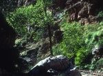
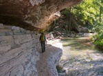
Hike Buck Farm Canyon, Colorado River, Grand Canyon, Arizona
Buck Farm Canyon is at Colorado River river mile 41 on river right. The canyon is along perennial creek and get narrow. There is some minor scrambling through some boulders at the beginning of this hike. -
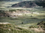
Hike Buck Hill Trail, Theodore Roosevelt National Park, North Dakota
You'll be on top of the world when you climb to the highest accessible point in the park. This is a short (0.2 mile), but steep trail. The view from the top is worth every step. -
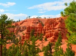
Hike Buckhorn Trail, Red Canyon, Utah
Buckhorn Trail #33037 extends into the scenic red rock terrain and takes you to a vantage point overlooking Red Canyon. This trail can be combined with the Goldenwall Trail and Red Canyon Bicycle Trail to make a nice five mile round trip. Castle Bridge Trail can be added to this combination, this would add a scenic side trail and a little more difficulty without addin... -
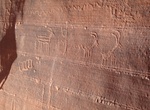
Hike to Buckskin Gulch Petroglyphs, Utah
The petroglyphs are located on the south (right) wall of Wire Pass just before the junction. Check the sky one last time because there is no exit from Buckskin Gulch until you reach the Middle Trail 6 1/2 miles down canyon. Hike down the flat bottom of Buckskin Gulch. -
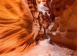
Hike Buckskin Gulch to Lees Ferry, Grand Staircase-Escalante National Monument, Utah
Buckskin Gulch to Lees Ferry is a 45.6 mile point-to-point trail located in Grand Staircase-Escalante National Monument, Utah. -
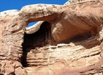
Hike to Bucktank Draw & Birthday Arch, Utah
Bucktank Draw and Birthday Arch is located off Utah Highway 89 at mile marker 9¾ or 17.3 miles from Carl Hayden Visitor Center. This is a easy to moderate 2-3 hour hike on sandy and partial bedrock sandstone leads you south to a box canyon, a large arch and a small sized slot canyon. The arch is located approximately 1.5 miles from the road snuggled in along t... -
Hike Buck Taylor Track Loop, Karekare, New Zealand
Buck Taylor Track is a short loop in the coastal Waitakere Ranges. Hike downhill from the Lone Kauri Road car park amid towering manuka, cabbage, and fern trees big enough to camp in to a marshy inlet banked by black sand dunes. -
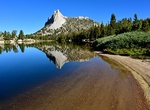
Hike to Budd Lake, Tuolumne Meadows, California
Budd Lake is a lake in the Tuolumne Meadows region of Yosemite National Park, United States. Budd Lake is the source of Budd Creek. Budd Lake was named for James Budd, 19th Governor of California. -
Hike or Mountain Bike Buffalo Beach to Airport in the Sky, Catalina Island, California
Start at Buffalo Beach at White Cove and take Whites Landing Cove Road up 2.9 miles to Fox Camp (Hen Rock) Road and turn right for a little and then left to connect with the Airport Road (at 3.3 miles) and turn north for to the Airport in the Sky (4.8 miles one way). Have a buffalo burger at DC3 Gifts & Grill and then head back to the beach. Note: You need a hiki... -
Hike Buffalo Point Trail, Antelope Island State Park, Utah
A short hike to Bison Point and exquisite views of the Great Salt Lake. -
Hike Buffalo River Trail, Arkansas
The Buffalo River Trail is a hiking and backpacking trail that follows the path of the Buffalo National River in Arkansas. The trail is thirty-seven miles long, and runs from Boxley Valley, Arkansas to Pruitt, Arkansas. The trail follows the path of the Buffalo National River in Arkansas and traverses the rugged Buffalo River country. Trailheads are located at Boxley ... -
Hike Bukit Besar, Sumatra, Indonesia
Bukit Besar measures 1700 meters above the sea level and is located in Perengai Village in South Sumatra. It takes roughly 3 hours hike to reach the peak where you can fully enjoy an amazing view. -
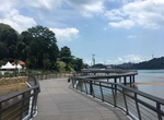
Stroll Bukit Chermin & Berlayer Creek Boardwalks, Keppel Bay, Singapore
The Bukit Chermin boardwalk stretches from the end of the Berlayer Creek Boardwalk to the Keppel Bay Bridge. Observe seagrass beds during low-tides and catch a glimpse of fishes during high-tides! This trail which takes about an hour to complete is home to a wide variety of endangered and vulnerable plant species - including the Bakau Pasir, a rare mangrove tree with ... -
Hike Bukit Gundaling Hill, Sumatra, Indonesia
Gundaling is a hill in Berastagi , Karo Regency , North Sumatra . Gundaling is a tourist attraction in Berastagi. Gundaling is located at 1,575 meters above sea level. The distance that can be traveled from Berastagi to Bukit Gundaling is around 2 km. The scenery that can be seen from Gundaling is Mount Sibayak and Mount Sinabung.


Price: $129.99