Give us feedback!


 See all

Our philosophy is simple. We want to encourage you to dream. BIG! Then we help you plan your trip, get the most out of it while you're traveling and help you share your experience with friends.
Join Now It's FREE
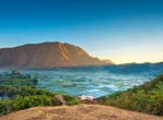
Dream Packages
Duration: 12 hours
Price: $224.21
Price: $224.21
Duration: 2 days
Price: $779.00
Price: $779.00
Duration: 4 days
Price: $1457.59
Price: $1457.59
Duration: 12 hours 30 minutes
Price: $289.36
Price: $289.36
Related Categories
- Australian National Parks & Reserves
- Canadian National Parks
- Canyoneering
- Day Hikes
- Guided Hikes
- In the Mountains
- Mountaineering
- Mountains
- New Zealand Great Walks
- New Zealand National Parks
- Parks & Reserves
- Rock Climbing
- South African National Parks
- UK National Parks
- UNESCO Parks & Preserves
- US Historical Parks (NHP)
Dreams Still To Do
Checked-Off Dreams
Dreams Still To Do
Checked-Off Dreams
Advertisement
Explore Hikes & Treks
-
Hike Bukit Pergasingan, Lombok, Indonesia
Bukit Pergasingan is an alternative hike for Rinjani mountain. It isn't as high, measures 1700m above sea level and the difficulty level is lower which makes a more accessible option. The views are equally stunning! -
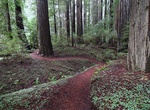
Hike Bull Creek Trail (North and South Loop), Honeydew, California
Bull Creek Trail North is accessible year-round and offers a walk through the forest primeval—the largest old-growth redwood forest remaining in the world! Start either at Lower Bull Creek Flats (1.1 miles west of Avenue of the Giants on Mattole Road) or Big Trees (4.1 miles west of the Avenue of the Giants on Mattole Road). When summer bridges are installed, yo... -
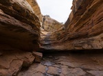
Hike Bullet Canyon, Utah
Bullet Canyon is a tributary and popular access route into Grand Gulch. A 7.2 mile, moderately difficult hike leads to the junction with Grand Gulch. Grand Gulch is a popular area for hiking and backpacking to see Ancestral Puebloan cliff ruins and rock art in a natural setting. Grand Gulch and its tributaries feature miles of winding canyons lined with cliffs that pr... -
Hike Bullhead Trail, Great Smoky Mountains National Park, Tennessee
The Bullhead Trail is an American hiking trail in the Great Smoky Mountains National Park, in Sevier County, Tennessee. 5.9 (6.9 to LeConte Lodge) miles (9.5 (11.1 to LeConte Lodge) km). The trail ascends Mount Le Conte, the tallest (and sixth highest) mountain east of the Mississippi River and offers outstanding views before joining the Rainbow Falls Trail befor... -
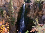
Hike Bullion Falls Trail, Bullion Canyon, Utah
The Bullion Falls Trail begins at the bridge over Pine Creek on the Bullion Canyon Road (FR-126) and ends at a 72 foor waterfall. You can't miss the trail head on your right. There is a rail car, pamphlets, shelter, etc. -
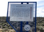
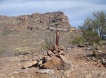
Hike Bullionville Trail, Cathedral Gorge State Park, Nevada
Easy walk from visitor center to Bullionville Cemetery. -
Hike Bull Pasture Trail, Organ Pipe Cactus National Monument, Arizona
Bull Pasture is a difficult 3 miles (5 km) round trip trail with steep grade and exposed cliffs. Spectacular views of Mexico and the monument. Can be done as a loop with Estes Canyon Trail. -
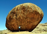
Hike to Bull's Party, Namibia
Bull's Party on farm Ameib is a great place to take photos depict the enormously impressing granite rock formations of Namibia. -
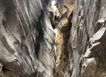
Hike Bull Valley Gorge, Grand Staircase-Escalante NM, Utah
Bull Valley Gorge is located in the upper Paria River valley in Grand Staircase-Escalante National Monument, Utah. There are several dryfalls (highest is 12 feet) and pools to negotiate. Use Skutumpah Road, also known as BLM 500, to get to Bull Valley Gorge. -
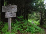
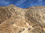
Hike Bump and Grind Trail, Palm Desert, California
Bump and Grind Trail is a 3.9 mile moderately trafficked loop trail located near Palm Desert, California that features beautiful wild flowers and is rated as moderate. The trail offers a number of activity options and is best used from October until May. -
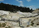
Hike Bumpass Hell, Lassen Volcanic National Park
Bumpass Hell is a hydrothermally altered geothermal area that spans 16 acres (65,000 m²) and has hot springs, fumaroles, and mud pots. It is named after Kendall Vanhook Bumpass, a cowboy who worked in the Lassen area in the 1860s. One day Bumpass stumbled upon the area and his leg was badly scalded when it broke though a thin crust above a mud pot. He told his f... -
Hike Bunchgrass Trail, Lava Beds National Monument, California
Bunchgrass Trail starts across from Site B-7 in the Indian Well Campground. Follow along the northeast side of Crescent Butte to the park road. Approximately 1 mile (1.6 km) long. Lava Beds has twelve hiking trails. The most popular trails are short, but lead to interesting historic sites and geological features. Due to resource concerns, pets and bicycles a... -
Hike or Mountain Bike Bunsen Peak, Yellowstone National Park, Wyoming
Bunsen Peak el. 8,564 feet (2,610 m) is a prominent peak due south of Mammoth Hot Springs in Yellowstone National Park, Wyoming. The peak lies on the east flank of Kingman Pass on the Mammoth to Norris section of the Grand Loop Road. The trail begins at the entrance of the Old Bunsen Peak Road Trail, 5.0 miles (8.0 km) south of Mammoth on the Grand Loop Road. Climb 1... -
Hike Burma Railway (Death Railway) & Bridge on the River Kwai, Thailand
The Burma Railway, also known as the Death Railway, the Thailand–Burma Railway and similar names, was a 415 kilometres (258 mi) railway between Bangkok, Thailand, and Rangoon, Burma (now Yangon, Thailand , built by the Empire of Japan during World War II, to support its forces in the Burma campaign. Forced labour was used in its construction. About 180,000 Asian... -
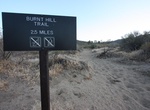
Hike Burnt Hill Trail, Joshua Tree National Park, California
Burnt Hill Trail is located off the Black Rock Canyon Trail in Joshua Tree National Park, California. Leave from the backcountry registration board and hike south on Black Rock Canyon Trail. Turn left at the Burnt Hill Trail sign. Return via Eureka Peak Trail, Fault Trail, and California Riding & Hiking Trail. Alternately, depart from site #30 via Black Rock Canyo...

Price: $263.77