Give us feedback!


 See all

Our philosophy is simple. We want to encourage you to dream. BIG! Then we help you plan your trip, get the most out of it while you're traveling and help you share your experience with friends.
Join Now It's FREE
Dream Packages
Duration: 12 hours
Price: $224.21
Price: $224.21
Duration: 12 hours
Price: $160.26
Price: $160.26
Duration: 4 hours
Price: $129.99
Price: $129.99
Duration: 10 hours
Price: $224.21
Price: $224.21
Related Categories
- Australian National Parks & Reserves
- Canadian National Parks
- Canyoneering
- Day Hikes
- Guided Hikes
- In the Mountains
- Mountaineering
- Mountains
- New Zealand Great Walks
- New Zealand National Parks
- Parks & Reserves
- Rock Climbing
- South African National Parks
- UK National Parks
- UNESCO Parks & Preserves
- US Historical Parks (NHP)
Dreams Still To Do
Checked-Off Dreams
Dreams Still To Do
Checked-Off Dreams
Advertisement
Explore Hikes & Treks
-
Hike Calavera Lake, Carlsbad, California
Calavera Lake is a 400-acre reservoir surrounded by miles of hiking and biking trails, 17 native vegetation communities, and land that was once an old rock quarry. There are multiple trails to choose from that vary in difficulty but you will be rewarded with sprawling views at the top. And you don’t have to travel far to see a natural wonder like a dormant volca... -
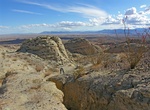
Hike Calcite Mine Area, Anza-Borrego Desert State Park, California
The Calcite Mine Trail is located in Anza-Borrego Desert State Park, California. There is a 4-mile long old mining road which was newly graded in winter 2025 into the Santa Rosa Mountains to a parking spot. It’s still quite winding & steep, but a fairly easy trek. Once there there are several narrow ravine with slot canyons that hikers may explore. During Wo... -
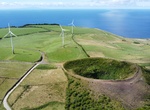
Hike Caldeirinha de Pero Botelho, Graciosa Island, Azores, Portugal
Hike to the top of Caldeirinha de Pero Botelho, a small cratera, for a great view of Graciosa Island. -
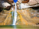
Hike to Calf Creek Falls, Utah
Calf Creek Falls is a perennial waterfall in the Grand Staircase-Escalante National Monument in Utah that totals 214 feet (65 m) and flow into a lush oasis and pool. The lower tier is a 126-foot (38 m) cascade and is very popular, because it can be reached by an easy hike on a 5½ mile roundtrip trail. The upper tier is a 88-foot (27 m) plunge and is much less ... -
Guided Hike to Caliche Forest, San Miguel Island, California
NOTE: Due to unexploded ordnance, visitors must be accompanied by a ranger to this location. Entering this area without a ranger is a violation of federal law.The San Miguel Island's isolation has helped to preserve one of the island's most interesting features-the caliche forest, calcified casts of ancient vegetation that have been exposed in several areas by the ero... -
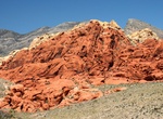
Hike Calico Hills Trail, Red Rock Canyon, Nevada
Calico Hills Trail runs along base of Calico Rocks, through Calico Basin, to Sandstone Quarry. Accessible from either Calico parking areas. Side trail runs to fee booth parking lot. Difficulty: easy to moderate. Distance: variable (depends on access point). -
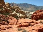
Hike to Calico Tanks, Red Rock Canyon, Nevada
Calico Tanks trail heads north, from Sandstone Quarry, and meets Turtlehead Peak Trail. Trail runs up a side canyon and rock terraces finally ending at a large natural water tank. Difficulty: moderately strenuous (rock scrambling and route finding skills recommended). Distance: 2.5 miles (4.0 km) round trip. -
Hike or Ride California Riding and Hiking Trail (Chariot & Banner Canyons), California
The California Riding and Hiking Trail has its own interesting history. The vision for it began in 1945 when the state Legislature passed the California Riding and Hiking Trails Act, calling for a single 3,000-mile loop trail from Mexico to the Oregon border. By the 1960s, some 1,060 miles of the trail had been completed statewide. In San Diego, 108 miles of the trail... -
Hike or Ride California Riding and Hiking Trail (Joshua Tree National Park)
Thirty-five (35) miles of the California Riding and Hiking Trail in Joshua Tree National Park passes through pinyon/juniper forests, Joshua tree forests and creosote-dominated lowlands. You can access the trail at Black Rock Campground, Upper Covington Flats, Ryan Campground, Twin Tanks parking, and just south of north entrance. Two to three days are required to hike... -
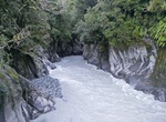
Hike Callery Gorge Walk, New Zealand
The Callery Gorge Walk in Westland Tai Poutini National Park begins in the Franz Josef Waiau township, at the end of Cowan Street. This 10.4 km up and back trail climbs to a high terrace before descending to the Callery River. The track narrows through the rainforest, and follows alongside an old gold mining water race. The water race and some rusty relics are among t... -
Hike Call of the Canyon Trail (West Fork Oak Creek), Red Rock-Secret Mountain Wilderness, Arizona
Call of the Canyon Trail is located in Oak Creek Canyon north of Sedona, Arizona. The trail follows West Fork Oak Creek. It's shaded most of the hike, and frequently crosses the creek so you can stop and refresh. The 3.2 mile hike takes 2-3 hours round trip. Call Of The Canyon Picnic Site is a picturesque day use site in Oak Creek Canyon is at the trailhead. There i... -
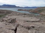
Hike Callville Summit Trail, Nevada
A short climb will reward hikers with a spectacular view. To the south sit Fortification Hill, Boulder Basin, Hemenway Valley, Boulder City and the River Mountains. Looking east, hikers can see the Callville Bay developed area, Callville Mesa and the Black Mountains. The Trailhead is located next to the Callville dump station across from the picnic area. Distance: 1... -
Hike or Bike Calumet Trail, Indiana Dunes National Park, Indiana
The trail follows the South Shore Railroad tracks and NIPSCO power lines. There is no shade. The trail can be impassible (i.e. wet shoes) due to standing water along much of the trail that can be 4-6" deep in spots. The trail is not suitable for road bikes.The Calumet Trail connects to many trail systems. The west trailhead parking lot connects to the Porter Brickyard... -
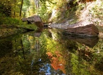
Hike to Calypso Cascades, Colorado
Calypso cascades is a multi tiered waterfall which offers multiple angles to photograph. A short trail to a broad waterfall tumbling over mossy boulders, known for wild orchids in summer. -
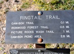
Hike & Ride Cam-Boh Trail, Saguaro National Park, Arizona
This trail runs parallel to Picture Rocks Road from Cam-Boh Picnic Area to the Ringtail Trail. As a major connection between the east and west parts of the Tucson Mountain District, the Cam-Boh Trail pro - vides several loop opportunities for both equestrians and hikers.


Price: $121.33