Give us feedback!


 See all

Our philosophy is simple. We want to encourage you to dream. BIG! Then we help you plan your trip, get the most out of it while you're traveling and help you share your experience with friends.
Join Now It's FREE
Dream Packages
Duration: 4 hours
Price: $129.99
Price: $129.99
Duration: 4 hours
Price: $129.99
Price: $129.99
Duration: 6 to 10 hours
Price: $86.83
Price: $86.83
Duration: 10 hours
Price: $121.33
Price: $121.33
Related Categories
- Australian National Parks & Reserves
- Canadian National Parks
- Canyoneering
- Day Hikes
- Guided Hikes
- In the Mountains
- Mountaineering
- Mountains
- New Zealand Great Walks
- New Zealand National Parks
- Parks & Reserves
- Rock Climbing
- South African National Parks
- UK National Parks
- UNESCO Parks & Preserves
- US Historical Parks (NHP)
Dreams Still To Do
Checked-Off Dreams
Dreams Still To Do
Checked-Off Dreams
Advertisement
Explore Hikes & Treks
-
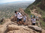
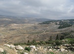
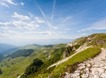
Hike Camelback Mountain, Phoenix, Arizona
Camelback Mountain is a mountain in Phoenix, Arizona, United States. The English name is derived from its shape, which resembles the hump and head of a kneeling camel. The mountain, a prominent landmark of the Phoenix metropolitan area, is located in the Camelback Mountain Echo Canyon Recreation Area between the Arcadia neighborhood of Phoenix and the town of Paradise... -
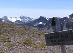
Hike Cameron Pass Trail, Olympic National Park, Washington
Cameron Pass Trail is a 28.6 mile out and back trail from Obstruction Point that is rated as difficult. Permits for this area should be obtained at the Wilderness Information Center (WIC) in Port Angeles. Snow can persist on Cameron Pass into Late July or August. Ice axe and self-arrest skills recommended when the pass is snow-covered. Permits/Reservations: Obtain ... -
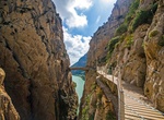
Hike Caminito del Rey "King's Walkway", El Chorro, Spain
El Caminito del Rey (The King's Little Path) is a walkway pinned along the steep walls of a narrow gorge in El Chorro, near Ardales in the province of Málaga, Spain. Its name derives from the original name of Camino del Rey (King's Pathway), abbreviated locally to el caminito. The walkway was constructed in the early 20th century, but by the early 21st century,... -
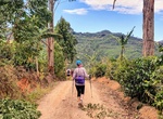
Hike Camino de Costa Rica (Way of Costa Rica), Costa Rica
The Camino de Costa Rica (Way of Costa Rica) is a 280 kilometres (170 mi) long hiking trail across Costa Rica. It runs from the Atlantic Ocean (Caribbean coast), the southernmost part of the Tortuguero canals, up the mountain and through indigenous territory near the Barbilla National Park and through valleys and mountain ranges of the central region of the country, j... -
Hike Camino de Egeria (Egeria Way), Jordan
Camino de Egeria is a 50km pilgrimage trail follows the path of a 4th-Century nun who journeyed through the Holy Land – centuries before Spain's famed Camino de Santiago. The Egeria Way (Camino de Egeria), is a part of the larger John the Baptist trail that starts in Rasas and finishing in Al-Maghatas (or Bethany beyond the Jordan), its a spiritual and historica... -
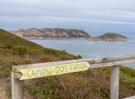
Trek Camino dos Faros (Lighthouse Way), Spain
The Camino dos Faros or Lighthouse Way is a coastal walking trail in Spain going along the wild and rugged beauty of the Costa da Morte, in the Atlantic coast of Galicia. The trail passes 11 lighthouses between the towns of Malpica to Finisterre. Stay in the quaint fishing villages to get the chance to sample the freshest treats from the sea. Ponteceso, for instance,... -
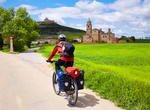
Trek Camino Francés (French Way), Spain
The French Way (Galician:Camiño francés, Spanish:Camino francés, literally the "way of the Franks") is the most popular of the routes of the Way of St. James (Spanish:Camino de Santiago), the ancient pilgrimage route to Santiago de Compostela in Galicia, Spain. It runs from Saint-Jean-Pied-de-Port on the French side of the Pyrenees to Roncesvalles... -
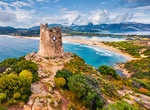
Trek Cammino 100 Torri (Way 100 Towers), Sardinia, Italy
The Cammino 100 Torri (Way 100 Towers) is a multi-day trekking route that begins and ends in Cagliari (Sardinia). The path is named after the 105 historical coastal towers along the route. The path extends throughout the island of Sardinia for 1284 kilometers (798 miles) making it the longest trek in Italy. The trek can be divided into two paths: the eastern path and ... -
Hike Cammino Retico (The Rhaetian Way), Dolomites, Italy
Cammino Retico (The Rhaetian Way) is a hike in Northern Italy that opened in 2024. The 170km (106 miles) circular trail can be done in seven days. It begins (and ends) in Aune di Sovramonte, near the city of Belluno. There are 10 villages along the route in the Veneto and Trentino regions, with accommodation for hikers. The route crosses plateaus, valleys, and mounta... -
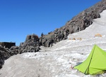
Hike to Camp Muir, Mount Rainier National Park
Camp Muir, named for the naturalist John Muir, is a high-altitude refuge for climbers on Mount Rainier in Mount Rainier National Park The shelters comprising the camp are situated at a 10,188 ft (3,105 m) elevation between the Muir Snowfield and the Cowlitz Glacier on Mt. Rainier. Camp Muir is the most-used base camp for those attempting to climb to the mountain's sum... -
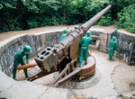
Visit Cannon Fort, Cat Ba, Viet Nam
Cannon Fort is a perfect place to have an amazing view of Cat Ba island and Ha Long Bay. It takes up to 40 minutes to climb up. -
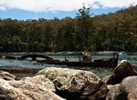
Hike to Canoe Bay, Tasman National Park, Tasmania
A short walk along the Tasman Trail from the beach at Fortescue Bay, suitable for families, leads to Canoe Bay (about 2 hours round trip). Canoe Bay contains an old steel boat wreck and was, until the early 1970's, the site of a fish processing works. -
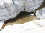
Hike Cañon de Guadalupe (Guadalupe Canyon), Baja California
This paradise is a lush oasis located within the Sierra de Juarez, boasting mineral hot springs, natural swimming pools, and palm trees. Each campsite has its own natural hot springs pool to enjoy. There’s beautiful hiking in the area with waterfalls and natural pools to explore as well as rock climbing and cave painting sites. When to Visit: The campsites and h... -
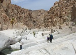
Hike Cañon del Diablo to Picacho del Diablo, Baja California
Cañon del Diablo is a canyon in Sierra de San Pedro Mártir National Park, Baja California. It can be hiked form either the west (mountain route) or east (desert route - ~30 miles west of San Felipe). The canyon is often used to summit Picacho del Diablo, the highest peak in Baja California, measuring 3,096 metres (10,157 ft). East route: There is a park... -
Hike Cañon de Santa Maria, Baja California
The hike down Cañon de Santa Maria (Arroyo San Francisquito) starts east of San Antonio de las Minas, about 2 miles from Rancho Santa Inés Airstrip. The canyon below the mission has one main repelling section. Make sure everyone has the correct gear to do this hike. Note: This is a one-way trip down the canyon unless you leave ropes attached for the re...
Price: $224.21