Give us feedback!


 See all

Our philosophy is simple. We want to encourage you to dream. BIG! Then we help you plan your trip, get the most out of it while you're traveling and help you share your experience with friends.
Join Now It's FREE
Dream Packages
Duration: 12 hours
Price: $160.26
Price: $160.26
Duration: 3 hours 15 minutes
Price: $371.99
Price: $371.99
Duration: 4 hours
Price: $149.99
Price: $149.99
Duration: 10 hours
Price: $121.33
Price: $121.33
Related Categories
- Australian National Parks & Reserves
- Canadian National Parks
- Canyoneering
- Day Hikes
- Guided Hikes
- In the Mountains
- Mountaineering
- Mountains
- New Zealand Great Walks
- New Zealand National Parks
- Parks & Reserves
- Rock Climbing
- South African National Parks
- UK National Parks
- UNESCO Parks & Preserves
- US Historical Parks (NHP)
Dreams Still To Do
Checked-Off Dreams
Dreams Still To Do
Checked-Off Dreams
Advertisement
Explore Hikes & Treks
-
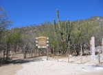
Hike Canon San Bernardo, Sierra de la Laguna, Baja California Sur, Mexico
Canon San Bernardo is located in Sierra de la Laguna in Baja California Sur, Mexico. The hike goes from Boca de la Sierra (eastern side of the mountains) to Santo Domingo (western terminus). This 14-mile hike takes two to three days route and stays in the canyons the entire way with permanent pools provide drinking water along the way. Expect to find tough boulder hop... -
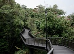
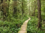
Hike Canopy Walk, Telok Blangah Hill Park, Southern Ridges, Singapore
Canopy Walk is a 300-metre (980 ft) trail which links Kent Ridge Park to Reflections at Bukit Chandu – once known as Opium Hill and site of one of the last battles of Singapore in World War II and HortPark. Elevated 16 metres (52 ft) at the centre, Canopy Walk goes through secondary forest with groves of Tembusu and dominant trees of the adinandra belukar. It is... -
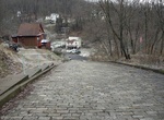
Go up Canton Avenue, Pittsburgh, Pennsylvania
Canton Avenue, in Pittsburgh, Pennsylvania's Beechview neighborhood, is the steepest officially recorded public street in the United States. Canton Avenue is 630 ft (190 m) long (the hill is about 65 meters long) and is claimed to include a 37 percent grade 21 ft (6.4 m) feet long. According to the Guinness Book of World Records, Baldwin Street, in Dunedin, New Zealan... -
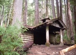
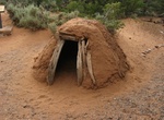
Hike to Canyon Creek Shelter (Sol Duc Falls Shelter), Olympic National Park, Washington
The Canyon Creek Shelter, also known as the Sol Duc Falls Shelter, is a rustic trail shelter in Olympic National Park. It is the last remaining trail shelter built in the park by the Civilian Conservation Corps from Camp Elwha. The shelter was built in 1939, shortly after Olympic National Park was established from the U.S. Forest Service-administered Mount Olympus Nat... -
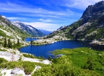
Hike Canyon Creek Trail, Trinity Alps Wilderness, California
Canyon Creek Trail is a spectacular and long trail in Trinity Alps Wilderness. The hike is not strenuous except for a few steep areas around the lakes. Start early as most of the trail ends up in the sun. Follow the cairns on the steep section that follows mostly alpine and granite surfaces. -
Hike or Ride Canyon Loop Trail, Catalina State Park, Arizona
Canyon Loop Trail is an easy 2.3 miles, loop hike through the foothills that begins and ends at the Trailhead parking lot. The loop is created by a link connecting the Romero Canyon Trail and the Sutherland Trail. The trail is relatively flat, but about halfway around there is a slope with approximately 90 stairs. There is a bypass trail around the steps for horses. P... -
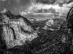
Hike Canyon Overlook Trail, Zion National Park, Utah
The Canyon Overlook Trail is a short (1 mile roundtrip) easy family hike to a great overlook of Zion canyon. The trail begins with a series of steep stairs and then continues to rise along the cliff ledge. Great views from here during sunset. There are 2 parking lots. The first parking lot is to the right just after about 20 meter from the end of the tunnel. The ... -
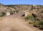
Hike or Off-road to Canyon Padre Bridge, Arizona
Luten arch bridge over Padre Canyon on an old alignment of Route 66. To get t the bridge take the Winona exit off Interstate 40 and double back east on the north frontage road. -
Hike Canyons Trail, Jewel Cave National Monument, South Dakota
This trail is rough and uneven due to the washouts that occur during heavy rains, please be prepared for this if you hike the trail. Please check at the visitor center to see if trail is open. The trail begins at the covered patio outside the Jewel Cave National Monument visitor center lobby and winds its' way down into Lithograph Canyon. Turning right at a fence th... -
Hike Canyon View Trail, Navajo National Monument, Arizona
Canyon View Trail offers a view of head of Betatakin Canyon. It leads leads from the visitor center to campground (0.6-mile round trip). -
Hike Canyon X, Arizona
Canyon X is a slot canyon just a few feet wide but more than 100 feet deep near Lake Powell in northern Arizona. This canyon has a lot of the same gorgeous features as nearby Antelope Canyon but without the crowds. It is on Navajo land that is privately run and is fenced off. Visits to Canyon X require a Navajo Reservation permit and are limited to four people at a t... -
Hike Cape Alava Trail, Olympic National Park, Washington
Cape Alava Trail is 3.3 miles one way partly on boardwalk from near the ranger station to the coast. A 2.9 mile beach walk connects with Sand Point Trail to the south making a 9.0 mile loop. Cape Alava, in Clallam County, Washington, U.S., is the westernmost point in the contiguous 48 states (during low tide and walking out to the west side of Tskawahyah Island). The ... -
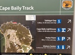
Hike Cape Baily Track, Botany Bay National Park, New South Wales, Australia
Cape Baily Coast Walk is a 5.5 km, grade 3 hike located in the Botany Bay National Park, New South Wales. Cape Baily Lighthouse is a scenic stop along track in the Kurnell area of Kamay Botany Bay National Park, near Cape Solander. -
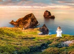
Hike to Cape Brett Lighthouse (Cape Brett Track), New Zealand
Cape Brett Lighthouse is a lighthouse at Cape Brett in the Northland Region of the North Island of New Zealand. The site was surveyed and chosen in 1908 by Captain John Bollons of NZGSS Hinemoa. The lighthouse was deactivated and keepers withdrawn in 1978 and replaced by an automated beacon on the same site. -
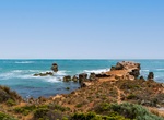
Hike Cape Buffon Walk, Canunda National Park, South Australia
Cape Buffon Walk is a 2.5 km loop hike in Canunda National Park.


Price: $129.99