Give us feedback!


 See all

Our philosophy is simple. We want to encourage you to dream. BIG! Then we help you plan your trip, get the most out of it while you're traveling and help you share your experience with friends.
Join Now It's FREE
Dream Packages
Duration: 14 hours
Price: $341.00
Price: $341.00
Duration: 8 hours
Price: $214.32
Price: $214.32
Duration: 2 days
Price: $779.00
Price: $779.00
Duration: 4 hours
Price: $129.99
Price: $129.99
Related Categories
- Australian National Parks & Reserves
- Canadian National Parks
- Canyoneering
- Day Hikes
- Guided Hikes
- In the Mountains
- Mountaineering
- Mountains
- New Zealand Great Walks
- New Zealand National Parks
- Parks & Reserves
- Rock Climbing
- South African National Parks
- UK National Parks
- UNESCO Parks & Preserves
- US Historical Parks (NHP)
Dreams Still To Do
Checked-Off Dreams
Dreams Still To Do
Checked-Off Dreams
Advertisement
Explore Hikes & Treks
-
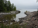
Hike Burnt Point Loop Trail, Bruce Peninsula, Ontario, Canada
The Burnt Point loop was built by volunteers of the Peninsula Bruce Trail Club for the opening of the Visitor Centre in 2006. The Burnt Point Loop trail is accessible from the Visitor Center and takes about 1.5 - 2 hours to hike. The first part, about 800 meters, to the bay is wheel chair friendly. -
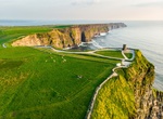
Hike Burren Way, County Clare, Ireland
The Burren Way (Irish:Slí Bhoirne) is a long-distance trail in County Clare, Ireland. It is 114 kilometres (71 miles) long, begins in Lahinch and ends in Corofin, crossing The Burren, one of the largest karst limestone landscapes in Europe. The trail, typically completed in five days, comprises sections of tarmac road, boreen, droving road, path and forestry tr... -
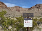
Hike Burro Spring Trail, Big Bend National Park, Texas
Burro Spring does not always have water. There are several interesting displays of geology in the form of walls and boulders. -
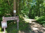
Hike Butcher Branch Trail, New Haven, West Virginia
The Butcher Branch Trail is an alternative start to the Long Point Trail. This wooded trail connects the Kaymoor Top area to the Long Point Trail, with a spur to the popular Butcher Branch climbing area. There are steep sections and a small stream crossing on this trail. -
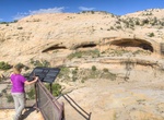
Hike to Butler Wash Ruins, Utah
Butler Wash Ruin is a cliff dwelling that was built and occupied by the Ancestral Puebloans, sometimes known as Anasazi, in about 1200 AD. Parts of the site has been stabilized and reconstructed, but most of it remains as it was found in the 1800s. There are habitation, storage and ceremonial structures, including four kivas. This ruin is located in a side canyon of B... -
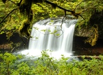
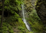
Hike to Butte Creek Falls, Oregon
Upper and Lower Butte Creek Falls, is a waterfall located in the south edge of the Table Rock Wilderness at the east end of the city of Salem, in Marion County, in the U.S. state of Oregon. It is located in a privileged area on the east foothills of Drake Crossing. Several prominent rivers and waterfalls are located in the Butte Creek Falls trail system. A paved foot ... -
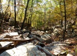
Hike Butterfield Hiking Trail, Devils Den State Park, Arkansas
The Butterfield Trail is a looped backpacking trail beginning in Devil's Den State Park near the park's pavilion, the trail crosses Hwy. 74 and passes near Mount Olive. Scenic views, such as Blackburn Creek and Vista Point, are plentiful. Rock formations and mountainous outcroppings provide photographers with dramatic subjects. Backpackers must obtain a free permit at... -
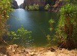
Hike Butterfly Gorge Walk, Nitmiluk National Park, Northern Territory, Australia
Butterfly Gorge Walk is a short walk of 1.7 km within Nitmiluk National Park. -
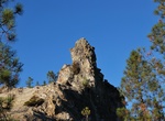
Hike Buzzard's Roost, Big Basin Redwoods State Park, California
This is one of the favorite Big Basin hikes: It starts on the legendary Redwood Trail near the park headquarters, heads over to Blooms Creek Campground and zigags up the Pine Mountain Trail -- leaving the redwood forest completely for awhile -- then culminating with a steep scramble to a rocky overlook. All in just over two miles one way. You can see pretty much all t... -
Hike to Byrampen Viewpoint & Fjellstua, Ålesund, Norway
Climb the 418 steps up to Fjellstua restaurant alonng a w ell maintained paths. Stop at Byrampen Viewpoint for amazing views of the city. There are numerous rest spots where you can sit and rest. Great place for a sunset. -
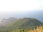
Hike Cabeço do Canto, Faial Island, Azores, Portugal
Cabeço do Canto is a volcanic cone on island of Faial, archipelago of the Azores. There is a lava tube and bunker in the area. -
Hike to Cabin Creek Falls, Starvation Creek State Park, Oregon
Cabin Creek Falls is located along Starvation Ridge Trail in Starvation Creek State Park, Oregon. -
Hike Cabin Trail, Pahranagat National Wildlife Refuge, Nevada
This trail begins outside the Main Entrance to the Visitor Center just over the bridge and concludes at two historic cabins built by early settlers in the Pahranagat Valley. Make sure to stop and read the interpretative signs by each cabin! Open Season: Open year-round Length: 0.4 miles one way, 0.8 miles round trip Location of ... -
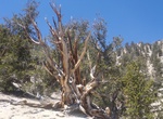
Hike Cabin Trail (Methuselah Trail), Ancient Bristlecone Pine Forest, California
Cabin Trail (Methuselah Trail) is A 4.5 mile loop with a cumulative alevation change of 900 feet. Numbered posts and a brochure guide you along the trail. Several rest benches have scenic views. The Methuselah Tree is along this trail, but there is not a sign that points it out. This trail can be combined with the Bristlecone Cabin Trail. Methuselah is a Great Basin ... -
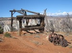
Hike to Cable Mountain Draw Works, Zion National Park, Utah
The Cable Mountain Draw Works was built by David Flanigan beginning in 1901, although he had first proposed the system as a teenager in 1885.From 1904, timber was harvested from the heights above the valley and moved from Cable Mountain down to the draw works in the valley, a vertical distance of 2,000 feet (610 m). The system fulfilled an 1863 prophecy made by Brigha...

Price: $772.57