Give us feedback!


 See all

Our philosophy is simple. We want to encourage you to dream. BIG! Then we help you plan your trip, get the most out of it while you're traveling and help you share your experience with friends.
Join Now It's FREE
Dream Packages
Duration: 10 hours
Price: $199.57
Price: $199.57
Duration: 10 hours
Price: $121.33
Price: $121.33
Duration: 4 days
Price: $663.61
Price: $663.61
Duration: 6 hours 30 minutes
Price: $167.71
Price: $167.71
Related Categories
- Australian National Parks & Reserves
- Canadian National Parks
- Canyoneering
- Day Hikes
- Guided Hikes
- In the Mountains
- Mountaineering
- Mountains
- New Zealand Great Walks
- New Zealand National Parks
- Parks & Reserves
- Rock Climbing
- South African National Parks
- UK National Parks
- UNESCO Parks & Preserves
- US Historical Parks (NHP)
Dreams Still To Do
Checked-Off Dreams
Dreams Still To Do
Checked-Off Dreams
Advertisement
Explore Hikes & Treks
-
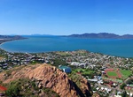
Summit Castle Hill, Townsville, Australia
Castle Hill is both a heritage-listed isolated pink granite monolith standing in the heart of the north Queensland city of Townsville and a suburb of Townsville. It rises to a height of some 286 metres (938 ft) above sea level and dominates the city skyline. It is one of the most distinctive natural features on the Queensland coast. There are a number of vantage point... -
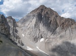
Summit Castle Peak, Elk Mountains, Colorado
Castle Peak is the ninth highest summit of the Rocky Mountains of North America and the U.S. state of Colorado. The prominent 14,279-foot (4352.2 m) fourteener is the highest summit of the Elk Mountains and the Maroon Bells-Snowmass Wilderness. The peak is located 11.6 miles (18.7 km) northeast by north (bearing 32°) of the Town of Crested Butte, Colorado, United ... -
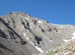
Explore Castle Peaks Corridor (Hart Mine Road), Mojave National Preserve, California
For excellent views of the Castle Peaks spires, walk 4 miles one way up the closed road to the ridgetop and beyond into a small canyon. Start4.9 miles east of Ivanpah Road on signed Hart Mine Road; left at fork, then 0.9 miles, left at fork, then 3.4 miles, crossing an earthen berm; left at fork, then 1 mile more to where road ends. High clearance and four-wheel dri... -
Summit Castle Peak (White Cloud Mountains), Idaho
Castle Peak, at 11,815 feet (3,601 m) above sea level is the highest peak in the White Cloud Mountains of Idaho. Castle Peak is the 25th highest peak in Idaho, and the 9th most prominent peak in the state. Castle Peak is located within the White Clouds Wilderness, which is part of Sawtooth National Recreation Area in Custer County. The towns of Stanley, Idaho and Chal... -
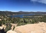
Hike Castle Rock Trail, Big Bear Lake, California
Beautiful Hike on a marked trail, 2 miles round trip. Family friendly, bring water. -
Hike Castle Rock Trail, Grandview, West Virginia
This strenuous 0.6 mile trail begins near Main Overlook and ends where it intersects the Grandview Rim Trail, approximately ½ mile from Main Overlook. Hikers will find close-up views of towering fortress-like rock walls and exposed coal seams. The Castle Rock Trail and Grandview Rim Trail can make a great one mile loop. This loop will take hikers below the over... -
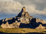
Hike Castle Trail, Badlands National Park, South Dakota
The longest trail (10 miles/16 km) in the park begins at the Door and Window parking area and travels five miles one way to the Fossil Exhibit Trail. Relatively level, the path passes along some badlands formations. Walking the Castle Trail (west for sunrise, east for sunset) is a great way to view the changing light on the north side of the Wall and provides a wonde... -
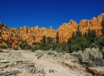
Hike Casto Canyon Trail, Dixie National Forest, Utah
The Casto Canyon trail has some of the most spectacular red rock formations in the state. The limekiln area has many stunning views of white and green rock formations. From this loop Peterson Point can be accessed, offering spectacular views overlooking the city of Panguitch and the valleys below and a great lunch stop. The Fremont Trail is a section of this loop the... -
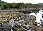
Hike Castorera Loop, Tierra del Fuego National Park, Argentina
Castorera Loop is a 1.3 mile loop trail within Tierra del Fuego National Park. Will offer a chance to see natural habitat of beavers, a species introduced in the area of Isla Grande de Tierra del Fuego around 1946. -
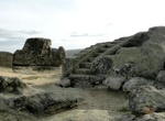
Hike to Castro de Ulaca Sacrificial Altar, Spain
The Castro of Ulaca is the ancient capital of the Vettones (a Celtic Tribe) on a fortified mountain. It has the remains of a temple and sacrificial altar. The sanctuary or sacrificial altar of Ulaca is one of the best preserved of the pre-Roman towns in Europe. It is an area of about 60 m2 that houses a large rock carved in a way that has three differentiated parts... -
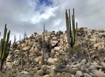
Hike Cataviña Boulder Fields, Cataviña, Baja California, Mexico
Explore the Boulder Fields around Cataviña. -
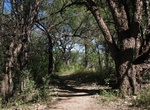
Hike Cat Cave Trail Loop, Sonoita Creek State Natural Area, Arizona
Cat Cave Trail connects Coal Mine Spring Trail with Encino and Sonoita Creek campsites. Start the hike at the Sonoita Creek trailhead and take the following trails: Sonoita Creek Trail - 1.5 miles Railroad Trail - 2.5 miles Cat Cave Trail - 2.5 miles Coal Mine Spring Trail - 1 mile Sonoita Creek Trail - 1.5 miles (return) Horses allowed along Railroad Trail,... -
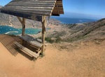
Hike to Cat Harbor Lookout, Santa Catalina Island, California
Cat Harbor Lookout is located off Banning House Rd near Two Harbors on Santa Catalina Island. -
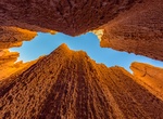
Explore Cathedral & Canyon Caves (Slot Canyons), Nevada
Known locally as "caves," the park's extremely narrow slot canyons were cut from the mud that lay at the bottom of the lake millions of years ago. Explorers can crawl through tunnels to discover hidden chambers in the network of canyons which offer some coolness in the summer heat. -
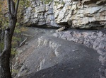
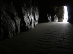
Hike to Cathedral Caves & Waipati Beach, New Zealand
The Cathedral Caves are one of the thirty longest sea caves in the world, located on Waipati Beach, 15 kilometres (9.3 mi) south of Papatowai, on the Catlins Coast in the southeast corner of the South Island, New Zealand. They are one of the most popular tourist attractions in the area, along with the McLean Falls, the highest water falls in the Catlins, located 4.9 k...
Price: $572.77