Give us feedback!


 See all

Our philosophy is simple. We want to encourage you to dream. BIG! Then we help you plan your trip, get the most out of it while you're traveling and help you share your experience with friends.
Join Now It's FREE
Dream Packages
Duration: 8 hours
Price: $214.32
Price: $214.32
Duration: 12 hours
Price: $160.26
Price: $160.26
Duration: 10 hours
Price: $224.21
Price: $224.21
Duration: 12 hours
Price: $263.50
Price: $263.50
Related Categories
- Australian National Parks & Reserves
- Canadian National Parks
- Canyoneering
- Day Hikes
- Guided Hikes
- In the Mountains
- Mountaineering
- Mountains
- New Zealand Great Walks
- New Zealand National Parks
- Parks & Reserves
- Rock Climbing
- South African National Parks
- UK National Parks
- UNESCO Parks & Preserves
- US Historical Parks (NHP)
Dreams Still To Do
Checked-Off Dreams
Dreams Still To Do
Checked-Off Dreams
Advertisement
Explore Hikes & Treks
-
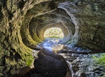
Hike to Cave Stream (Broken River Cave), New Zealand
Cave Stream, also known as Broken River Cave, is a 594 metres (1,949 ft) long cave in New Zealand, located on State Highway 73. It is 40 kilometres (20 mi) from Arthur's Pass and 100 kilometres (62 mi) from Christchurch. It's a short hike form the parking lot. It is a popular site for passing tourists, however in spring and during heavy rains it can be dangerous to en... -
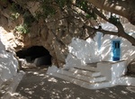
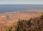
Hike up to Cave Zoodochos Pigi (Church of Life Giving Source), Santorini, Greece
Cave Zoodochos Pigi (Church of Life Giving Source) is a small church, "hanging" on the rocks of the mountain above Kamari. -
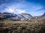
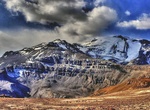
Summit Cayambe, Ecuador
Cayambe or Volcán Cayambe is a volcano in Ecuador, in the Cordillera Central, a range of the Ecuadorian Andes. It is located in Pichincha Province, some 70 km (43 mi) northeast of Quito. It is the third-highest mountain in Ecuador, at an elevation of 5,790 m (18,996 ft) above sea level. Cayambe, which has a permanent snow cap, is a Holocene compound volcano whi... -
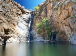
Hike Cedar Creek Falls (Devil's Punchbowl), Ramona, California
Cedar Creek Falls is lcoated in Ramona, California is a scenic waterfall and natural pool at the end of the trail. Ceder Creek Falls can definitely be a challenging and fun hike, but be smart and be prepared. To limit the number of visitors, a permit is required: $6 for every 5 people. It said to be one of the most dangerous trails in the county–temperatures ge... -
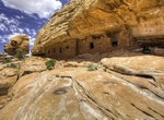
Hike to Cedar Mesa Citadel Ruins (The Citadel), Utah
Citadel Ruin is located at the end of a point overlooking Road Canyon in Cedar Mesa, Utah. The hike is about 4 mile roudtrip. There is a nice area to camp at the trailhead (which is at the end of a dirt road overlooking the canyon). Use is allocated by the total number of overnight visitors at each trailhead per day. Large groups (eight to twelve people), groups wit... -
Hike to Celestial Falls, Oregon
Celestial Falls is the second step of the major falls of the White River, and was formerly considered to be part of White River Falls itself. The falls drop 41 feet over a uniform ledge, plunging into a large pool at the base of the formation, with White River Falls visible just 180 linear feet upstream. The falls feel oddly out of place in the gently undulating footh... -
Hike Centennial Trail, Wind Cave National Park, South Dakota
The Centennial Trail is located in the northern end of Wind Cave National Park and continues north into Custor State Park. This 6.0 miles (9.7 km) hike (one way) is moderately strenuous trail and goes across prairies, through forested areas, and along Beaver Creek. It will take at least a 1/2 day to cover the 6 mi of this trail that traverse the park. The trail is pa... -
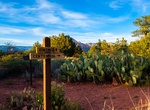
Hike to Centennial Trail Viewpoint, Sedona, Arizona
A short, easy, paved hike to a 270° view of the mountains surrounding Sedona and the basin to Red Rock Country. Trailhead at Girdner/Cultural Park Trailhead. Great spot for sunsets. -
Visit Centerville Beach Cross, California
The Centerville Beach Cross is a monument that commemorates the 17 passengers and 21 crew members who died in the shipwreck of the SS Northerneron January 6, 1860. The vessel, owned by the Pacific Mail Steamship Company, struck a rock near Cape Mendocino and wrecked on Centerville Beach, in Humboldt County, California. The monument is registered as California Historic... -
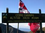
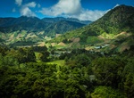
Summit Cerro Chirripó, Costa Rica
Cerro Chirripó is the highest mountain in Costa Rica, with an altitude of 3,820 metres (12,533 ft). It is located in the Chirripó National Park and is noted for its ecological wealth. The high peaks in this and La Amistad International Park host important areas of Talamancan montane forest and Costa Rican Páramo with high endemism and an extremely... -
Summit Cerro de Punta, Ponce, Puerto Rico
Cerro de Punta or just Cerro Punta is the highest peak in Puerto Rico, rising to 1,338 meters (4,390 ft) above sea level. The mountain is part of the Cordillera Central and is located in the municipality of Ponce. The mountain is part of the Cordillera Central and is located on the border between the municipalities of Jayuya and Ponce. The access road to the point clo... -
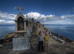
Hike to Cerro El Calvario, Copacabana, Bolivia
The hilltop overlooking Lake Titicaca was rededicated as a "calvario" or replica of Calvary and is topped by the Stations of the Seven Sorrows of Mary and an altar with a depiction of the crucifixion of Jesus. It is a major centre of worship throughout the region during Holy Week, especially on Good Friday and Easter Sunday. -
Summit Cerro El Coronel, Rosarito, Baja California, Mexico
One of the most popular hikes in the Rosarito area is Cerro El Coronel. The hike up the large hill is moderate and takes 5-7 hours so be sure to take plenty of drinking water and snacks. There are signs for the trail that you’ll find along the free road near Puerto Nuevo. For an easier hike, there are a number of trails surrounding the new Parque Metropolitano, ... -
Summit Cerro El Plomo, Santiago
Cerro El Plomois a mountain located in the Andes near Santiago, Chile. With an elevation of 5,434 m (17,783 ft), it is the largest peak visible from Santiago on clear days. The adequate season to climb this mountain is between November and March. In spring (September to November), soil conditions have abundant snow on the approach. The best time is in January and Marc... -
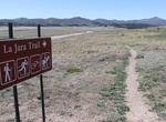
Hike Cerro la Jara Trail, Valles Caldera National Preserve, New Mexico
You are walking in a volcanic caldera – a depression formed during a volcanic eruption. This caldera was formed as the result of a very large volcanic eruption about 1.2 million years ago. It is somewhat circular in shape and 12 to 15 miles across. Alluvial fans get their name from their shape and what they are made of. Rocks, sand, and silt moved and deposited ...


Price: $371.99