Give us feedback!


 See all

Our philosophy is simple. We want to encourage you to dream. BIG! Then we help you plan your trip, get the most out of it while you're traveling and help you share your experience with friends.
Join Now It's FREE
Dream Packages
Duration: 4 days
Price: $663.61
Price: $663.61
Duration: 3 hours 15 minutes
Price: $371.99
Price: $371.99
Duration: 10 hours
Price: $224.21
Price: $224.21
Duration: 4 days
Price: $1457.59
Price: $1457.59
Related Categories
- Australian National Parks & Reserves
- Canadian National Parks
- Canyoneering
- Day Hikes
- Guided Hikes
- In the Mountains
- Mountaineering
- Mountains
- New Zealand Great Walks
- New Zealand National Parks
- Parks & Reserves
- Rock Climbing
- South African National Parks
- UK National Parks
- UNESCO Parks & Preserves
- US Historical Parks (NHP)
Dreams Still To Do
Checked-Off Dreams
Dreams Still To Do
Checked-Off Dreams
Advertisement
Explore Hikes & Treks
-
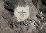
See Cerro Prieto Rock Graphiti, Mexicali, Baja California, Mexico
Cerro Prieto ("Black Hill") is a volcano located approximately 29 km (18 mi) SSE of Mexicali in the Mexican state of Baja California. The volcano lies astride a spreading center associated with the East Pacific Rise. This spreading center is also responsible for a large geothermal field which has been harnessed to generate electric power by the Cerro Prieto Geothermal... -
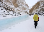
Hike Chadar Trek, Zanskar Gorge, Kashmir, India
The Chadar Trek through the Zanskar Gorge is a winter expedition in the Himalaya. The river ice can shift and break and present other hazards, but the biggest danger is the cold itself. The Zanskar Gorge is found in the Zanskar region of Indian-administered Kashmir. Its walls are near vertical cliffs up to 600m high and the Zanskar River (a tributary of the Indus) is ... -
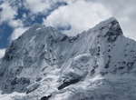
Summit Chakrarahu, Peru
Chakrarahu is a mountain in the Cordillera Blanca in the Andes range of Peru. The mountain has two distinctive peaks Chakrarahu Oeste (west summit) and Este (east summit). The west summit has an elevation of 6,108 metres (20,039 ft), the east of 6,001 metres (19,688 ft). Chakrarahu is situated in the Ancash Region, Huaylas Province, Caraz District, and in the Yungay P... -
Climb Champe Rocks, West Virginia
Champe Rocks are a pair of large crags in Pendleton County in the Eastern Panhandle of West Virginia, USA. Easily visible from West Virginia Route 28, they are situated within the Spruce Knob-Seneca Rocks National Recreation Area. They are — along with the nearby and more celebrated Seneca Rocks — the most imposing examples in eastern West Virginia of seve... -
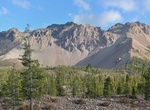
Hike Chaos Crags, Lassen Volcanic National Park, California
Chaos Crags is the youngest group of lava domes in Lassen Volcanic National Park, California, having been formed as five dacite domes 1,100-1,000 years ago. The cluster of domes is located north of Lassen Peak. From the base of the crags and extending toward the northwest corner of the park is Chaos Jumbles, a cold rock avalanche which undermined Chaos Crags' northwes... -
Hike Chaparral Crest Trail to El Nido Trailhead, Ojai, California
This Chaparral Crest Trail to El Nido Trailhead is about 2.4 miles long (each way) and located near Ojai, California. The trail is great for hiking and normally takes 2 hours (round trip) more or less. This guide takes you from the end of a 2.4 outing, back to one of 3 available trail heads. This is part of a reall great Ojai Land Conservancy trail system along the Ve... -
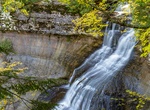
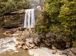
Hike to Chapel Falls, Pictured Rocks National Lakeshore, Michigan
Chapel Falls is located about 15 miles east of Munising off Alger County Road H-58, then about 5 miles north to the end of Chapel Road. After a brisk 1.5 mile walk, hikers can view the 60-foot high Chapel Falls as it cascades toward Chapel Lake.The trail is on an old roadbed with several small hills. Two viewing platforms along the way provide views of the scenic Chap... -
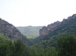
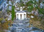
Hike to Chapel Santa Barbara, Riva del Garda, Lake Garda, Italy
Hiking trail to the St. Barbara Chapel. This picturesque chapel was built by the miners during the construction of the Hydroelectrical power plant. Wonderful view of the lake and Riva del Garda downtown. -
Backpack to Charlies Bunion, Great Smoky Mountains
Charlies Bunion is a mountain in the Great Smoky Mountains of the Southeastern United States, characterized by a large boulder-like protrusion just below the summit on its otherwise-sheer northern face. The mountain is a rare instance of a bare-rock summit in the Smokies. Charlies Bunion rises to an elevation of 5,565 feet (1,696 m) above sea level, and is situat... -
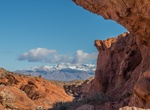
Hike to Charlie's Spring, Valley of Fire State Park, Nevada
Charlie's Spring Trail goes down a wash for 1.2 miles to North Fork Valley of Fire Wash. The trail is not marked - just stay in the wash and travel down like water. CLOSURE NOTICE: Due to the heat from Mid May to the end pf Sept, rangers close all trails longer than 1 mile - which might include this one. -
Hike Charlie Turner Trail, Griffith Observatory, LA, California
The Charlie Turner Trail begins at the north end of the Griffith Park Observatory parking area. Charlie Turner Trail (also sometimes referred to as Mount Hollywood Trail) is named after a man who volunteered in Griffith Park during the 1970s. -
Hike or Mountain Bike Charming Creek Walkway to Mangatini Falls, New Zealand
Hike to Mangatini Falls along Charming Creek Walkway along the Ngakawau river near Ngakawau, New Zealand. Scenery and history combine as you walk on an old railway formation. The Charming Creek Walkway is 19 km out and back and takes about 6 hours to hike. Mountain bike is intermediate grade 3. There are two points of access to the walkway. The southern end is clear... -
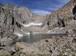
Hike to Chasm Lake, Colorado
Hiking area in Larimer County, Colorado -
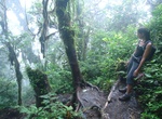
Hike Chato Volcano, Fortuna, Costa Rica
Chato Volcano sometimes called "Cerro Chato", is an inactive volcano in north-western Costa Rica north-west of San José, in the province of Alajuela, canton of San Carlos, and district of La Fortuna. It is southeast of the nearby Arenal Volcano. It is believed Cerro Chato first erupted 38,000 years ago during the Pleistocene period and last erupted about 3,500 ... -
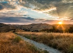
Hike Cheeseboro Canyon Trail to Modelo Trail Loop, Agoura Hills, California
Follow a flat old ranch road through valley oak savannah before ascending up a ridge for panoramic views of the Simi Hills during your return to the trailhead. Trailhead at Cheeseboro & Palo Comado Canyons.

Price: $167.71